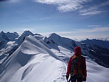
Breithorn (Zermatt)
| Breithorn | ||
|---|---|---|
|
The Breithorn from the Klein Matterhorn seen |
||
| height | 4164 m above sea level M. | |
| location | Canton of Valais , Switzerland / Aosta Valley , Italy | |
| Mountains | Valais Alps | |
| Dominance | 4.03 km → Castor | |
| Notch height | 436 m ↓ Schwarztor | |
| Coordinates , ( CH ) | 45 ° 56 '28 " N , 7 ° 44' 52" O ( 623 975 / 87772 ) | |
|
|
||
| First ascent | 1813 by Henry Maynard , Joseph-Marie Couttet , Jean Gras , Jean-Baptiste Erin and Jean-Jacques Erin | |
| Normal way | Glaciated alpine tour | |
The Breithorn is a five-peaks, west to east running, heavily glaciated mountain ridge in the Valais Alps . The highest point of the ridge and at the same time the easiest four-thousand-meter peaks in the Alps is the west summit (main summit, Breithorn Occidentale, 4164 m above sea level ). Further to the east follow the middle summit (Breithorn Centrale, 4159 m above sea level ) and the Breithorn twins, consisting of the east summit (western twin, Breithorn Orientale, 4139 m above sea level ) and the gendarme (eastern twin, Quota, 4106 m above sea level ). The Breithornkamm ends in the east with the Schwarzfluh (Roccia Nera, 4075 m above sea level ).
Between Klein Matterhorn and Breithorn there is the Breithorn Pass ( 3814 m above sea level ) and the Breithorn plateau ( 3795 m above sea level ), which extends over the highest ski slope in Europe towards Gobba di Rollin ( 3899 m above sea level ) . Between the west and middle peaks lies the saddle (Sella, 4076 m above sea level ), between the middle and east peaks the Selle (Fenestra del Breithorn, 4022 m above sea level ) and the Schwarztor (Porta Nera, 3734 m above sea level). M. ) between Roccia Nera (Schwarzfluh) and Pollux (Polluce). There is also the Bivac Rossi e Volante CAI ( 3787 m above sea level ) at Roccia Nera . The main Alpine ridge and the border between Valais and the autonomous region of Aosta run over the Breithorn .
The first ascent was made in 1813 by Henry Maynard , Joseph-Marie Couttet , Jean Gras , Jean-Baptiste Erin and Jean-Jacques Erin .
Because of the 3870 m above sea level. M. high Klein Matterhorn leading cable car is climbed often the technically undemanding main summit. The normal route leads from the south-southwest first over the firn of the Breithorn plateau and later up a 35 degree steep slope. The ascent takes between one and a half and three hours. The descent on skis or snowboards from the main summit is easy for experienced riders. Despite the good development, it is a high-alpine tour that requires the appropriate equipment and experience.
As an alternative, you can also climb the west summit from the east over a narrow ridge , which is a very easy traversal of the highest summit of the Breithorn. The starting point of the ridge is the notch between the west and middle summit on the saddle (Sella 4076 m above sea level ), from where you can also climb the middle summit over the further course of the ridge. Up to the central summit, the Breithorn consists only of ice and snow to the west, combined with rock to the east. The tour from the east to the west summit is also known as the half-wide horn traversing with climbing up to level IV .
Zermatt mountain guides refer to alpinists as “Breithoru-Liit” (Breithorn people) who can only be taken up the Breithorn with a clear conscience.
literature
- Helmut Dumler, Willi P. Burkhardt: Four-thousanders in the Alps. 12th, updated edition. Bergverlag Rother, Munich 2001, ISBN 3-7633-7427-2 .
Web links
Individual evidence
- ↑ Breithoru-Liit. In: The large Zermatt Lexicon. zermattportal.de - Schmellenkamp Communications, accessed on February 14, 2013 .


