Paleomagnetism
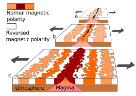
Paleomagnetism (colloquially also fossil magnetism ) is the preservation of various characteristics of the earth's magnetic field in rocks at the time of their deposition or formation. The measurement of remanent magnetism on rocks is an important geophysical tool and a research direction in historical geology . Since both the earth's magnetic field changes again and again in geological periods ( pole shift ), as well as the continental plates on which the rocks were formed, their position in the earth's magnetic field as a result of the continental drift constantly change, the magnetic orientations handed down in rocks can provide information about the time and place of rock formation or deposition.
The results of paleomagnetic analyzes combined with the results of other geological and geophysical investigations in the 1960s verified Alfred Wegener's theory of continental drift ( plate tectonics ) and later the theory of the Wilson cycle ( supercontinent cycles) based on it.
Causes of rock magnetization
Remanent magnetization based on the earth's magnetic field is found in all three rock classes . In igneous rocks , e.g. B. basalt , it arises during the cooling process and is therefore called thermally remanent magnetization . If the temperature falls below the so-called Curie temperature , the particles of ferromagnetic minerals align themselves in the direction of the currently prevailing earth's magnetic field and essentially maintain this alignment.
Also sedimentary rocks can be magnetized retentive. Ferromagnetic mineral particles, such as. B. magnetite , which are contained in the sediment, align after or during the embedding according to the currently prevailing geomagnetic field. This orientation is fixed by compacting and cementing the sediment to form a rock during diagenesis . This mechanism is called detritus or sedimentation remanence.
In both cases, different characteristics of the earth's magnetic field (field vectors, field strength) are preserved at the time of rock formation. If the rock was not subjected to a stronger metamorphosis afterwards or was even melted again (heating above the Curie temperature), these characteristics of the paleomagnetic field can be "read out" today using suitable methods.
While the magnetization of igneous rocks is stronger and less easily destroyed than that of sediments, it usually only provides palaeomagnetic field data for a few, but can be dated absolutely absolutely , because igneous rocks are only formed in very specific development phases of a section of the earth's crust . In contrast, the formation of sediments, especially in the deeper areas of a sea basin, occurs almost continuously over a much longer period of time, so that the local field is continuously recorded. However, the dating of sedimentary rocks can only be relative, e.g. B. be done with the help of fossils . Large volcanic eruptions, the ash deposits of which can be identified as layers in sediments of a crustal section, allow precise temporal references (correlations) between the two types of data sets, i.e. That is, between the magnetization of a lava and lapilli rock belonging to a particular eruption and the paleomagnetic field data of the sediments in which the corresponding ash deposits occur.
Applications in science
With measurements of the remanent magnetization, the direction to the magnetic north pole, and by measuring the strength of the magnetization of the crystals, the geographical latitude can be determined. The previous longitude cannot be measured. With these measurements, a possible migration of the continental plate, on which the rock formed, between the north and south poles or its rotation can be determined. The migration in east-west direction cannot be measured palaeomagnetically. The resulting measurements by the apparent change in position of the geomagnetic poles (polar wandering) can be used for the construction of Polwanderkurven ( engl. Apparent Polar Wander Path , APWP ). They describe the movement of a continent over the course of the earth's history.
A second area of application is magnetostratigraphy , in which the sequence of normal, i.e. corresponding to the current direction of the earth's magnetic field, and inverse magnetization is used to classify rocks over time.
Individual evidence
- ↑ see e.g. BNR Nowaczyk, HW Arz, U. Frank, J. Kind, B. Plessen: Dynamics of the Laschamp geomagnetic excursion from Black Sea sediments. Earth and Planetary Science Letters. Vol. 351–352, 2012, pp. 54–69, doi : 10.1016 / j.epsl.2012.06.050 (alternative full text access : xa.yimg.com ).
literature
- Heinrich C. Soffel: Paleomagnetism and Archaeomagnetism. An introduction for geoscientists. Heidelberg, Springer Verlag 1991, ISBN 3-540-53890-9
