Grande Traversata delle Alpi
| Grande Traversata delle Alpi | |
|---|---|
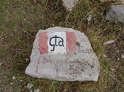
 Path marking with the lettering "gta" |
|
| Data | |
| length | approx. 1000 km |
| location | Piedmont, Italy |
| Starting point |
Molini di Calasca 46 ° 0 ′ 18 " N , 8 ° 10 ′ 51.5" E |
| Target point |
Viozene 44 ° 8 ′ 39.8 " N , 7 ° 46 ′ 59.2" E |
| Type | Long-distance hiking trail |
| The highest point | 2764 m |
| Lowest point | 295 m |
| Level of difficulty | heavy |
| season | summer |
| Months | June to October |
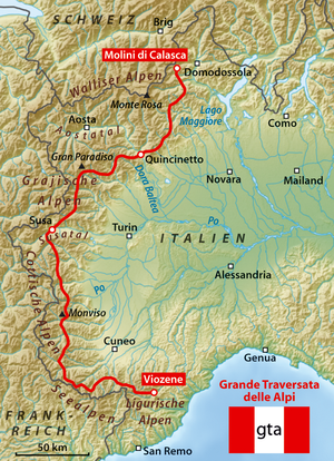
The Grande Traversata delle Alpi (GTA) is an Italian long-distance hiking trail that crosses the entire Piedmontese western Alps in around 1000 km and 65 daily stages , from the Valais Alps , Graian Alps to the Cottian Alps to the Maritime Alps and Ligurian Alps . Since this part of the Alps is divided into numerous transverse valleys, the daily stages often run over passes that connect high valley locations with one another; other stages are high-altitude trails within a valley.
course


It is useful to distinguish between a northern part and a southern part, the border of which is assumed to be the deeply cut Susa valley . The GTA can be committed in both directions; In accordance with the German-speaking guides, it is described below from north to south:
Access to the northern part is problematic. The original plan to start the GTA on Lake Maggiore was never realized due to a lack of suitable accommodation. An attractive option for hikers arriving from Switzerland starts at the Griespass ; Another entry begins in Saas Almagell and only meets the GTA stages in Alagna Valsesia. The official entry is at Molini di Calasca in the Valle Anzasca ; Forno in Valstrona is more suitable . The path leads on the north side of the Valsesia to Alagna on Monte Rosa . The Aosta Valley to the west was left out; the path turns south, touches the pilgrimage site of Oropa and reaches in Quincinetto at the breakthrough of the Dora Baltea with 295 m the lowest point of the entire GTA. The path then leads in six stages to the west, past the Gran Paradiso to the vicinity of the French border, which it follows from there to the south. After crossing three valleys, which all flow into the lowlands at Lanzo Torinese , you reach Susa after a total of 26 stages .
In the southern part, the GTA is divided into different variants several times. A pre-alpine variant ("east route") that can be walked on from the beginning of June has been abandoned in the area between the Susa and Varaita valleys: there are not accommodations everywhere, markings can only be found sporadically, and paths are becoming overgrown. On the other hand, the more western main variant is continuously accessible; the infrastructure tends to be better than in the northern part. From the Susa valley the GTA runs south. It crosses the Chisone , Germanasca and Pellice valleys . Then you have to bypass the Monviso , either west through the French Queyras , or east over two huts of the Italian Alpine Club. Both variants come together in the Valle Varaita . The GTA then crosses the Maira , Grana , Stura di Demonte , Gesso, Vermenagna valleys before it leads into the Ligurian Alps and ends there in Viozene ( Ormea municipality ) near the border with Liguria (crossings to France into the Mercantour National Park are from the Stura -, Gesso and Vermenagna valley possible).
The GTA is usually snow-free from the end of June. Under this condition, it is a mountain hiking trail without technical difficulties. Orientation in lonely terrain with irregular markings and the path that is not always clearly recognizable is sometimes demanding. The physical difficulty results from the facility as a pass hike from Quertal to Quertal; typical height differences are 600 to 1200 m ascent and descent per day. Some of the stages are very long, especially in the northern part.
Infrastructure
The path from Forno to Viozene can be walked without a tent. Overnight accommodations are set up at all stages ("posto tappa", marked with a red, white and red GTA mark). With a few exceptions, half-board is offered there. The majority of the Posti Tappa are located in high valley locations, where there is usually a shop. Some of the accommodations are rather Spartan (dormitory with double bunk beds, for example in an old school house or in an alpine hut), but some also have old furniture in private houses. A few stages end in Alpine Club huts . In place of pilgrimage Oropa one is pilgrim accommodation used.
The GTA is part of the Sentiero Italia along its entire length . The path is uniformly marked in red-white-red, sometimes with black lettering "gta", sometimes also "SI". In larger towns, the entry point is often difficult to find, and only a few locals there know the GTA. The quality of the markings on the way varies greatly; it often changes at the top of a pass.
In addition to the GTA and its French counterpart, the Grande Traversée des Alpes , the western Alpine arc is also crossed by the red and blue path of the Via Alpina . The Via Alpina tends to run at a higher altitude and relies more on Alpine Club huts than the GTA; however, several stages run together. Thanks to EU funding, there are overview boards in the stage towns.
The 50,000 maps of the Turin Istituto Geografico Centrale (IGC) are notoriously unreliable. You are urgently warned against relying on entries outside the GTA: some of these entries have not been updated for decades; many roads are overgrown, some washed away by landslides. In the 1990s, with EU support in a Franco-Italian joint project, some cross-border 50,000 cards were produced in the usual high quality of the French Institut géographique national ; however, they are out of print. On site you can occasionally purchase maps from local publishers in scales between 40,000 and 25,000 and in very different qualities.
A hiking guide from Werner Bätzing is regularly published in German ; Additional information and corrections are provided on two websites (see below).
Photojournalists and book authors Iris Kürschner and Dieter Haas have published the hiking guide GTA - Grande Traversata delle Alpi in Bergverlag Rother .
Landscape and culture
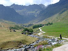
In terms of ecological altitude levels, the GTA is not an alpine , but a predominantly montane and subalpine route. Most of it runs through a densely populated cultural landscape that used to be intensively used.
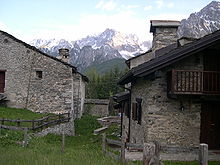
Traditional mountain farming largely collapsed over the course of the 20th century. The valleys touched by the GTA suffered a population decline of often 80% from 1870 to 2000; upper valley locations even from 90 to 95%. Some hamlets, in which a hundred people used to live, are completely abandoned, in others one or two old people still live. Some of the descendants return in the summer months and set up the inherited property as a second home, while the majority of the houses fall into disrepair.
Since the collapse of the traditional structures occurred much later than in neighboring France, there is still ample opportunity at the GTA to observe relics of the old economy. The GTA often follows old paths that used to connect the individual hamlets of a municipality. Particularly impressive (and pleasant to use) are the paved "mulattieras" ( mule tracks ) in the chestnut forests of the colline altitude. This area was densely populated until a chestnut disease suddenly destroyed the previous nutritional basis at the beginning of the 20th century. At higher altitudes you can always discover the boundary walls of old arable terraces, as grain was also grown in every community for self-sufficiency. In some areas, especially in the northern part, the alpine farming is still alive .
The alpine valleys were culturally independent and had closer contact with neighboring regions in France and Switzerland than with the Po Valley through numerous pass connections that were within walking distance . The main Alpine ridge did not form a linguistic border until well into the 20th century . The Valsesia is an old settlement area of the Walser . In the Lanzo Valleys , as in the Aosta Valley, Franco-Provencal ("Arpitan") was spoken. In the lower Susa valley, as in the lowlands, Piedmontese was spoken. South of the Susa valley was a closed Occitan language area. It was only in the trenches of the First World War that a significant part of the population learned Italian . In the second half of the 20th century, the decline in regional languages could no longer be stopped; In some remote valleys, even at the beginning of the 21st century, there are still families who speak Occitan at home.
Another cultural peculiarity was the community of the pre-Reformation - Protestant Waldensians , who had a tolerated retreat in the Waldensian valleys Chisone, Germanasca and Pellice, interrupted by cruel persecution.
History of the GTA
The idea for the GTA comes from France, where a Grande Traversée des Alpes was set up around 1970 at the same time as the invention of the European long-distance hiking trails . From the mid-1970s, a group of Turin mountain enthusiasts around the Rivista della Montagna and the libreria della montagna began to work out the concept of a long-distance path along the Piedmontese Alpine arc. The honorary Comitato Promotore was later constituted as an association, the Associazione GTA . A route was laid down, accommodation was organized, part-time hosts were hired, public funds were raised to furnish the accommodations, the paths were marked, and new stages were always described in magazine articles; 1981–89 hiking guides appeared in book form. Organized trekking was offered for the first time in 1982, and intensive press and public relations work was carried out until the mid-1980s.
As a result of these efforts, the GTA experienced a boom from 1979 with up to 300 overnight stays per season and stage location. After a few years, however, the interest of Italian hikers waned and some 'posti tappa' on the eastern route in the southern part were closed. The commitment of the initiators also fell sharply; After a great voluntary development effort, it was not possible to give the GTA a permanently sustainable organizational structure and to raise funds from tourism and mountain area promotion to finance a secretariat. During the 1990s, the activities of the Associazione largely fell asleep.
Werner Bätzing has been promoting the GTA in the German-speaking area since 1985 as an example of ecologically compatible tourism; In 1989 he published a hiking guide that has been updated regularly since then. In addition to Bätzing, several other travel journalists and hiking guides did effective public relations work for the GTA through magazine articles and illustrated books. In fact, the number of trekking tourists from the German-speaking area increased sharply from the mid-1980s and roughly offset the decline in Italian hikers.
Today (2000s) the GTA is predominantly committed by hikers from the German-speaking area. On average, the hikers spend a good week on the GTA; there are many repeaters. The number of overnight stays in the individual stages can not be determined , but is typically in the order of 100 to 200 per season (from which one can deduce that around 1000 long-distance hikers are on the GTA per season). It is clear that any decrease in the number of overnight stays would jeopardize the continued existence of individual stage accommodations and thus the attractiveness of the GTA as a whole.
Stages (in north-south direction)
In the Pennine (Walliser) Alps , from Valle Anzasca to Dora Baltea
- From Molini di Calasca ( 480 m ) in the Valle Anzasca to the Alpe del Lago ( 1545 m )
- Via the Colle dell'Usciolo ( 2037 m ) to Campello Monti ( 1305 m ) in Valstrona
- Via the Bocchetta di Campello ( 1924 m ) to Rimella ( 1176 m )
- To Santa Maria di Fobello ( 1094 m )
- Over the Colle d'Egua ( 2239 m ) to Carcoforo ( 1304 m )
- Over the Colle del Termo ( 2351 m ) to Rima ( 1441 m )
- Via Colle Mud ( 2324 m ), Alpe Valmontasca and Alagna Valsesia to Sant'Antonio di Val Vogna
- Via Passo del Maccagno ( 2495 m ), Colle Lazoney ( 2395 m ), Colle della Mologna Grande ( 2364 m ) to the Rifugio Rivetti ( 2201 m )
- To San Giovanni d'Andorno ( 1020 m )
- Via the Colle della Colma to Oropa ( 1180 m )
- To the Rifugio Coda ( 2189 m )
- Over the Colle della Lace ( 2121 m ) to Maletto ( 1336 m )
- To Quincinetto ( 295 m , lowest point of the GTA, train station)
In the Graian Alps , from the Dora Baltea to the Susa valley
- To Scalaro / Le Capanne ( 1400 m )
- Over the Colle di Lavarossa ( 2100 m ) to Succinto ( 1164 m ) in Val Chiusella
- Via the Bocchetta delle Oche ( 2415 m ) to Piamprato ( 1551 m )
- To Ronco Canavese ( 948 m ) in Val Soana
- Over the Colle Crest ( 2040 m ) to Talosio ( 1225 m ) in the Valle Ribordone
- Over the Monte Arzola ( 2158 m ) and the Alpe di Colla ( 2171 m ) to San Lorenzo di Piantonetto ( 1045 m )
- Via Bertodasco ( 1175 m ), Perebella ( 1339 m ), S. Anna ( 1481 m ), Coste ( 1193 m ) and Fé ( 900 m ) to Noasca ( 1058 m )
- To Ceresole Reale ( 1501 m ) in the Valle dell'Orco
- Via the Colle della Crocetta ( 2641 m ) to Pialpetta ( 1069 m ) in the Val Grande
- Over the Colle di Trione ( 2486 m ) to Balme ( 1432 m ) in the Val d'Ala
- Over the Passo Ghicet / Paschiet ( 2435 m ) to Usseglio ( 1265 m ) in the Valle di Viù
- Over the Colle Croce di Ferro ( 2558 m ) to Truc (il Trucco, 1706 m )
- Descent to Susa ( 600 m )
In the Cottian Alps , from Val Susa to Valle Stura
- From Susa to Salbertrand ( 1032 m )
- Via the Testa dell'Assietta ( 2567 m ) to Usseaux ( 1416 m ) in Val Chisone ; Variant Meana di Susa ( 595 m ) - Alpeggio di Toglie ( 1534 m ) - Colle dell'Orsiera ( 2595 m ) - Usseaux ( 1439 m )
- Via the Colle dell'Albergian ( 2713 m ) to Balsiglia ( 1370 m , Posto Tappa out of service?)
- Via Didiero ( 1245 m , new Posto Tappa) and the Colle Serrevecchio ( 1707 m ) to Rodoretto ( 1432 m )
- Via Costa di Galmont ( 1651 m ) to Ghigo di Prali ( 1455 m , short stage in the Germanasca Valley )
- Via the Colle Giulian ( 2457 m ) to Villanova ( 1225 m ) in Val Pellice ; Unfortunately, the old path between Colle Giulian and Villanova was partially destroyed when a new path was built
- Over the Col del Baracun to the Rifugio Barbara Lowrie ( 1753 m )
- Via the Colle della Gianna ( 2525 m ) to the Pian Melzè ( 1750 m )
- Via Pian del Re ( 2020 m ) to Rifugio Quintino Sella (Monviso) ( 2640 m )
- Over the Passo di San Chiaffredo ( 2764 m ) and Castello ( 1608 m ) to Pontechianale ( 1614 m ); western variant Pian del Re - Col de la Traversette - Refuge du Viso - Passo di Vallanta - Rifugio Vallanta - Passo Losetta - Chianale - Colle del Rastel - Pontechianale
- Over the Colletto della Battagliola ( 2282 m ) to Chiesa di Bellino ( 1480 m ); Branch of a variant
- Over the Colle della Bicocca ( 2285 m ) to Elva ( 1637 m )
- Via Colle San Giovanni ( 1872 m ), Colle Bettone ( 1831 m ) and San Martino ( 1380 m ) to Palent ( 1480 m )
- To Celle di Macra ( 1270 m )
- Over the Monte Bastia ( 2134 m ) and the Passo delle Crosette ( 2180 m ) to the Santuario di San Magno ( 1761 m )
- Via the Colle Fauniera ( 2480 m ) and the Colle Valcavera ( 2416 m ) to Sambuco ( 1184 m )
In the Maritime Alps and the Ligurian Alps , from Valle Stura to Val Tanaro
- From Sambuco via Caserma del Vaccia and Besmorello to Bagni di Vinadio ; End of the variant that branches off in Chiesa di Bellino
- Over the Passo di Bravaria to Sant'Anna di Vinadio
- Via the Colle della Lombarda and the Rifugio la Grange to the Rifugio Questa; Variant Sant'Anna di Vinadio - Passo d'Orgials - Rifugio Malinvern - Rifugio Questa
- Via Pian del Valasco to Terme di Valdieri ( 1368 m )
- Via the Rifugio Morelli-Buzzi ( 2351 m ) and the Colle del Chiapous ( 2526 m ) to the Rifugio Genova-Figari ( 2020 m )
- Via the Colle delle Fenestrelle ( 2463 m ) to the Rifugio Soria Ellena ( 1840 m )
- Via San Giacomo di Entracque ( 1213 m ) and Caire della Truccia to Trinità di Entracque ( 1096 m )
- Via the Colle della Garbella ( 2170 m ) to Palanfrè ( 1379 m )
- Over the Passo di Ciotto Mieu ( 2274 m ) to Limonetto ( 1294 m )
- Via Colle di Tenda ( 1871 m ), Colla Piana ( 2219 m ) and Passo del Duca ( 1989 m ) to the Rifugio Garelli ( 1965 m )
- Via Porta Sestrera (Passo di Lapasse) to Rifugio Havis De Giorgio ( 1761 m )
- Over the Passo delle Saline ( 2174 m ) and the Rifugio Mongioie ( 1520 m ) to Viozene ( 1245 m )
Footnotes and references
- ↑ A complete listing of the 55 stages from south to north can be found in the Italian Wikipedia.
- ↑ Diagrams for population statistics in the articles on the individual municipalities in the Italian Wikipedia.
- ↑ The communities were organized in a decentralized manner: the church was in one hamlet, the town hall in another, and the school in another; therefore each hamlet was connected to each other by direct paths, whereby the route - around a ravine or down into the valley floor and up again? - was optimized for walking.
- ↑ Vogt 2008, p. 115ff.
- ↑ Vogt 2008, p. 129ff. In 2008 the Associazione GTA had shrunk to seven members; it is largely inactive except for one active member in the province of Cuneo. Their continued existence is justified by the fact that only the connection to this association, which is designed as a license, enables the accommodations to maintain their special status as "rifugio escursionistico" and thus to escape the stricter requirements of hotel and restaurant law.
- ↑ Vogt 2008, p. 130.
- ↑ Vogt 2008, p. 285ff. u. 315ff. When asked about figures that suggest sales, the willingness of hosts to provide information has a clear gap.
literature
- Werner Bätzing: Grande Traversata delle Alpi, Part 1: The North. Rotpunktverlag, Zurich, ISBN 3-85869-256-5 .
- Werner Bätzing: Grande Traversata delle Alpi, Part 2: The South. Rotpunktverlag, Zurich, ISBN 3-85869-257-3 .
- Iris Kürschner, Dieter Haas: GTA - Grande Traversata delle Alpi. Hiking guide. Bergverlag Rother, Munich 2015, ISBN 978-3-7633-4402-4 .
- Iris Kürschner, Dieter Haas: GTA - Grande Traversata delle Alpi. Illustrated book. Bergverlag Rother, Munich 2014, ISBN 978-3-7633-7063-4 .
- Eberhard Neubronner: The way. From Monte Rosa to the Mediterranean. Grande Traversata delle Alpi. Verlag Berg und Tal, Munich 2006, ISBN 3-939499-00-5 .
- Gillian Price: Through the Italian Alps: Grande Traversata Delle Alpi (GTA). Cicerone Press, 2005, ISBN 1-85284-417-5 .
- Luisa Vogt: Regional development of peripheral areas with tourism? An actor-oriented study using the example of the trekking project Grande Traversata delle Alpi. Franconian Geographical Society, Erlangen 2008, ISBN 978-3-920405-99-5 .
Web links
- GTA page of the province of Cuneo
- gtaweb: General tips
- GTA wiki (English) so far with current stage information and alternative route suggestions for the Maritime Alps and Ligurian Alps
- Report and very informative photos from the northern part of the GTA
- As a hiking trail with sections based on Open Street maps
- Information about the GTA


