
Susa Valley
| Susa Valley - Val di Susa | ||
|---|---|---|
 The Susa valley from the Sacra di San Michele |
||
| location | Metropolitan city of Turin , Piedmont , Italy | |
| Waters | Dora Riparia | |
| Mountains |
Graian Alps Cottian Alps |
|
| Geographical location | 45 ° 8 ′ 0 ″ N , 7 ° 3 ′ 0 ″ E | |
|
||

The Susa Valley ( Italian Val di Susa ) is a valley in the northern Italian metropolitan city of Turin and belongs to the Piedmont region . Located on the border with France , it is surrounded in the northeast by the Graian Alps and in the southwest by the Cottian Alps .
The SS 25 road from Turin to France runs through the valley, which runs in a west-east direction . At the eponymous town of Susa , the steep pass road branches off to the north to the Col du Mont Cenis ( 2083 m ) and the upper Maurienne . From the uppermost part of the Susa valley, the SS 24 leads over the Col de Montgenèvre ( 1854 m ) to Briançon .
geography

The valley extends for about 90 kilometers (as the crow flies 75 km) in a west-east direction and is flanked on both sides by several three-thousand-meter peaks . It takes its name from the town of Susa , which lies on the western edge of the lower Susa valley. The Dora Riparia flows through the valley and flows into the Po in Turin .
With an altitude difference of 3000 meters over seven kilometers between Susa and the Rocciamelone, the Susa Valley has extreme differences in relief. Here the pass road winds up to the Col du Mont Cenis ( 2083 m ) and to France. In the upper reaches the valley forks northwest to the high alpine valley head of Bardonecchia and southwest to Cesana Torinese or the border pass Col de Montgenèvre ( 1854 m ). In Cesana, the transition to Sestriere and Val Chisone branches off to the south .
Communities
Until 2009 the communities of the Susa Valley belonged to two different mountain area communities, the
- Comunità Montana Alta Valle di Susa (Upper Susa Valley, largest towns:Bardonecchia,Oulx,Cesana Torinese,SalbertrandandSestriere)
- Comunità Montana Bassa Valle di Susa e Val Cenischia (Lower Susa Valley and Cenischia Valley, largest towns:Susa,BussolenoandAvigliana).
The border between the upper and lower Susa valley corresponded roughly to the border that existed between the French (upper) and the Savoy (lower) valley area until 1713 during the Peace of Utrecht (from 1720 Kingdom of Sardinia-Piedmont ).
In 2009, as part of a mountain reform in Piedmont, the amalgamation of several Comunità montana became effective. The Comunità Montana Bassa Valle di Susa e Val Cenischia was merged with the Comunità Montana Alta Valle di Susa and the Comunità Montana Val Sangone to form the new Comunità Montana Valle Susa e Val Sangone . Their headquarters are in Bussoleno.
history
Colombano Romean, a stonemason from Ramats in the upper valley, built a hydraulic masterpiece from 1526 to 1533 that allowed the sunny but dry slopes of Exilles and Chiomonte to be supplied with water. A tunnel about 500 m long still fulfills this function today.
Protected areas
There are five nature reserves in the Susa Valley:
The almost 11,000 hectare nature park, which also extends to parts of the neighboring valleys Val Chisone and Val Sangone , was established in 1980 and named after the characteristic peaks of Monte Rocciavrè ( 2778 m ) and Monte Orsiera ( 2890 m ). In the almost uninhabited park, which is an excellent hiking area, the Certosa di Montebenedetto and the Certosa di Banda are located on the right orographic slope of the lower Susa Valley .
The approximately 4,000 hectare protected area in the upper Susa Valley, located between 1,000 and 2,600 m above sea level, was established in 1980 and includes large forests, mainly spruce and fir forests. On the high plateau between the Val di Susa and the Val Chisone , a memorial at the Testa dell'Assietta ( 2565 m ) commemorates the battle of the same name , in which in 1747 during the War of the Austrian Succession the French attacked the French who were heavily outnumbered. The 19th stage of the Giro d'Italia 2005 passed this monument .
- Parco Naturale dei laghi di Avigliana
- Riserva dell'Orrido di Foresto .
The approximately 180 hectare protected area was established in 1998 and includes the canyon-like gorge carved in by the Rio Rocciamelone , which over a mere seven kilometers covered the 3000 meter difference in altitude from the headwaters at the peak of the same name down to the valley. In the narrow gorge there is a Mediterranean microclimate, so that rare plants for the region can thrive there.
- Riserva dell'Orrido di Chianocco .
Only about 27 hectares in size and already established in 1980, this protected area includes a somewhat smaller gorge that the Rio Prebèc has eroded.
tourism
Hiking trails

- The high alpine long-distance hiking trail Alta Via Val di Susa leads in around nine days from Bardonecchia in the Alta Valle Susa to the Colle del Lys in the Bassa Valle di Susa .
- Six stages of the new cross-border long-distance hiking trail Via Alpina lead, coming from the northern neighboring valley Valle di Viù , through the Susa valley (stages D32 to D37). Continuing in a south-easterly direction, you come to Val Chisone .
- The Grande Traversata delle Alpi (GTA) long-distance hiking trail crosses the Piedmontese Alps and crosses the Susa Valley.
Attractions
The chapel on the 3538 m slm high Rocciamelone summit a little northeast of Susa is the highest place of pilgrimage in the Alps . The annual pilgrimage to the Madonna della Neve takes place on August 5th.
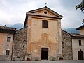
In the Middle Ages, important pilgrimage routes led through the Susa Valley , of which the route over the Mont-Cenis Pass (Italian: Colle del Moncenisio , French: Col du Mont-Cenis ), one of the busiest crossings in the Western Alps , also known as the Via Francigena ( or Via Romea ). It served pilgrims from Santiago de Compostela , southern France or from northern Europe on their way to Rome , which is why a large number of monasteries and hospices were built - which earned the valley the nickname "Valley of the Monasteries". The main attractions are the Sacra di San Michele monastery on the summit of the Pirchiriano Mountain , next to Sant'Antonio di Ranverso and the Abbazia di Novalesa, founded in 726 .

Arch of Augustus in Susa

Forte di Exilles
Abbazia Novalesa
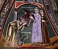
Abbazia Novalesa frescoes

Castel in Villar Dora


traffic

The A32 motorway from Turin to Grenoble runs through the valley . You can leave the Susa valley to the north via the Mont Cenis pass, while the Fréjus tunnel leads from Bardonecchia to France to the west. A railway line runs from Turin through the Susa Valley and the Fréjus tunnel to Chambéry in France .
The construction of a route for a high-speed train (Italian Treno ad Alta Velocità , TAV for short) through the Susa Valley has been in the planning stage since around 1989 . The express train connection through the Mont-Cenis base tunnel is to connect Turin with Lyon . In the summer of 2001, the French and Italian governments agreed on this project. The planning provides for a 15-year construction period and costs of 20 billion euros. The connection requires the construction of two tunnels: the east tunnel from Bruzolo to Venaus stretches over a length of 12 km, the west tunnel from Venaus to Saint-Jean-de-Maurienne measures 53 km. The projects are very controversial in northern Italy. In 2005, when test drilling for the project in the Susa Valley began, several demonstrations with 30,000–70,000 participants against the construction project took place in the valley. As part of these protests, the Susa Valley and the motorway were temporarily blocked and cut off from the outside world.
See also
- Alpine crossing
- Alps , section transit traffic
- CIPRA
literature
- Sabine Bade, Wolfram Mikuteit: Piedmont hiking . Michael-Müller-Verlag, Erlangen 2010, ISBN 978-3-89953-566-2
- Sabine Bade, Wolfram Mikuteit: Alta Via Val di Susa , Fernwege-Verlag, 2012 (3rd edition), ISBN 978-3-937304-77-9
- Sabine Bade, Wolfram Mikuteit, Partisan Paths in Piedmont. Places and ways of resistance between Gran Paradiso and Monviso , Querwege Verlag, Konstanz 2012, ISBN 978-3-941585-05-8
Web links
- Sabine Bade, Wolfram Mikuteit: Hiking in the Western Alps: The Cottian Alps , westalpen.eu, 2007.
Individual evidence
- ^ I Mestieri / le Metiers , escartons.eu.
- ↑ Michael Braun: Tal is rehearsing the uprising. taz.de, December 8, 2005, accessed July 31, 2011 .
- ↑ NoTav: momenti di tensione nella notte. Retrieved July 31, 2011 (Italian). , on youreporter.it