Parco naturale Orsiera - Rocciavrè
|
Parco naturale Orsiera - Rocciavrè
|
||
|
Monte Orsiera |
||
| location | Susa Valley , Val Chisone , Cottian Alps , Metropolitan City of Turin , Piedmont , Italy | |
| surface | 109.47 km² | |
| WDPA ID | 6027 | |
| Geographical location | 45 ° 3 ' N , 7 ° 13' E | |
|
|
||
| Setup date | 1980 | |
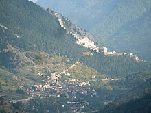
The Parco naturale Orsiera - Rocciavrè is a natural park in the Cottian Alps of the Italian metropolitan city of Turin in the Piedmont region .
The nature park was founded in 1980 and comprises areas of the mountain range between the lower Susa valley and the Chisonetal . It extends over an area of 10,947 hectares .
The highest peaks of the nature park are
- Monte Orsiera , 2878 m
- Punta Cristalliera , 2801 m
- Punta Malanotte , 2783 m
- Monte Rocciavrè , 2778 m
In the almost uninhabited park, which is an excellent hiking area, the Certosa di Montebenedetto and the Certosa di Banda are located on the right orographic slope of the lower Susa Valley . In the Chisonetal, the Forte di Fenestrelle mountain fortress, built here between 1728 and 1850, is particularly well known. The complex is the largest of its kind in Europe and consists of a series of individual fortifications connected by stairs and paths. The connecting stairs have a total of around 4000 steps. The facility was built by the fortress builder Ignazio Giuseppe Bertola Roveda to ward off a possible French invasion of Piedmont along the Val Chisone.
See also
literature
- Sabine Bade / Wolfram Mikuteit: Piedmont hiking . Michael-Müller-Verlag, Erlangen 2010, ISBN 978-3-89953-566-2
Web links
- www.parks.it - Official website of the nature park (Italian, English)


