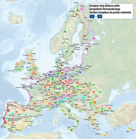
European long-distance hiking trails
The European long-distance hiking trails have been initiated by the European Hiking Association . One of the aims when it was founded in 1969 was to create a network of long-distance hiking trails through Europe that would bring people together. Over the years, twelve large long-distance hiking trails have been established on this basis .
The total length is approximately 60,000 km. Some of these are not or only very inadequately marked, or are still not really available to this day. In Central Europe , the paths and markings are mostly in a good to very good condition.
history
The first six European long-distance hiking trails E1 to E6 were largely defined by around 1979 and also marked with corresponding hiking trail boards. By 1999 there were eleven European long-distance hiking trails with the E7 to E11, covering a total of 52,000 kilometers. Since then, another one has been added with the E12.
Directory of paths
| Long-distance hiking trail | planned route | completed | Waymarking |
|---|---|---|---|
|
E1 (approx. 7000 km) |
from the North Cape to Sicily |
North Cape (N) to Salerno (I) |
 |
|
E2 (approx. 4850 km) |
from Galway to Nice |
from Hook of Holland (NL) to Nice (F) |
|
|
E3 (approx. 6950 km) |
from Cape St. Vincent to Istanbul |
from Santiago de Compostela (E) to Nesebâr (BG) |
 
|
|
E4 (approx. 10450 km) |
from Cape St. Vincent to Cyprus |
from Málaga (E) to Crete (missing section through Romania ) |
|
|
E5 (approx. 3050 km) |
from the Pointe du Raz to Venice |
from the Pointe du Raz (F) to Verona (I) |
|
|
E6 (approx. 5200 km) |
from Kilpisjärvi to the Dardanelles |
from Norrtälje (S) to Koper (SLO) |
|
|
E7 (approx. 5000 km) |
from the Canary Islands to Lisbon to Ukraine |
from Monfortinho (P) to Nădlac (RO) |
|
|
E8 (approx. 7500 km) |
from Dursey Head to Istanbul |
from Dursey Head (IRL) to the Beskids (border PL / UA), Romania , Bulgaria (partially) |
|
|
E9 (approx. 5000 km) |
from Cape St. Vincent to Narva-Jõesuu |
from Hendaye (F) to Braniewo (PL) |
|
|
E10 (approx. 2880 km) |
from Nuorgam to Tarifa |
from Rügen (D) to Ulldecona (E) (missing parts in I and F) |
|
|
E11 (approx. 2070 km) |
from The Hague to Poland |
from The Hague (NL) to Masuria (border PL / LT) |
|
|
E12 (approx. 2880 km) |
from Spain to the Adriatic Sea |
from Ceuta (E) via Barcelona (E), Nice (F), Genoa (I) and Salerno (I) to Koper (SLO) |
|
See also
- Via Alpina (long-distance hiking trail over the Alps, 341 stages through 8 countries)
- Grande Traversata delle Alpi (GTA) in Italy
- International Mountain Hiking Trail of Friendship Eisenach-Budapest (EB)
- Peaks of the Balkans
- Dream path Munich-Venice
- Sultan's Trail
- Way of St. James (pilgrimage routes)
- Lists of long-distance hiking trails in
- Benelux, France and Spain (GR long-distance hiking trails)
- Germany
- Austria
- Switzerland
- EuroVelo - The European long-distance cycle network
- Via dinarica in the Balkans
literature
- Frank Auerbach (Ed.): European long-distance hiking trails. Europe on foot. Steiger Verlag, ISBN 3-89652-177-2
- Hans Jürgen Gorges: On tour in Europe - The manual for European long-distance hiking trails. Deutscher Wanderverlag, 1999, ISBN 3-8134-0338-6
- Robert Wurst: On Europe's great ways , Verlag Styria 1996, ISBN 3-222-12346-2
Web links
Individual evidence
- ↑ Leo Strecker: European long-distance hiking trail 3 Atlantic - Bohemian Forest . II: Luxembourg - Bohemian Forest. Fink-Kümmerly + Frey, Stuttgart 1979, ISBN 3-7718-0330-6 .
- ↑ Hans Jürgen Gorges: On tour in Europe - The manual for the European long-distance hiking trails . Ed .: European Hiking Association. Deutscher Wanderverlag, Stuttgart 1999, ISBN 3-8134-0338-6 .

