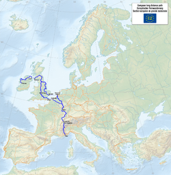
European long-distance hiking trail E2
| European long-distance hiking trail E2 | |
|---|---|

|
|
| Data | |
| length | 4850 km |
| Markers |

|
| Starting point |
Galway 53 ° 16 ′ 19 ″ N , 9 ° 2 ′ 56 ″ W. |
| Target point |
Nice 43 ° 42 ′ 7 ″ N , 7 ° 16 ′ 6 ″ E |
| Type | Long-distance hiking trail |
The European long-distance footpath E2 is part of the European footpath network and should lead from Galway in Ireland to Nice on the Mediterranean . The path has a total length of approximately 4850 km.
Details
Today the marked part of the trail begins in Stranraer, Scotland . Two variants go through England and across the English Channel ; mainland Europe is entered either in Ostend ( Belgium ) or in Hoek van Holland ( Netherlands ). From Zoersel (B) the long-distance hiking trail runs via Luxembourg to France , where it partially coincides with the GR 5 . The route through the Jura is the Grande Traversée du Jura (GTJ). Switzerland is briefly touched on Lake Geneva . Through the French Alps, where the path coincides with the GR 5 and the Grande Traversée des Alpes (GTA), the Mediterranean is finally reached.
Web links
- E2. In: traildino.com. Retrieved June 30, 2017 .
- Openstreetmap map
- The E2 in the Outdoorwiki