
Col de Clapier
| Col de Clapier | |||
|---|---|---|---|
_01.jpg) Col de Clapier, with a view of Turin at the top left |
|||
| Compass direction | west | east | |
| Pass height | 2488 m | ||
| region | Department of Savoie ( France ) | Region Piedmont ( Italy ) | |
| Watershed | Arc → Isère → Rhone | Dora Riparia → Po | |
| Valley locations | Bramans | Giaglione in the Susa Valley | |
| expansion | Mule track | ||
| Mountains | Cottian Alps | ||
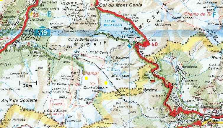
| map | |||
|
|||
| Coordinates | 45 ° 10 '3 " N , 6 ° 55' 22" E | ||

_02.jpg)

The Col de Clapier is a 2,488 m high mule pass over the Mont Cenis mountain range in the Cottian Alps , between Bramans in Savoy ( France ) and Giaglione in Piedmont ( Italy ). There is no paved road over the pass. Two hiking trails lead over the Col de Clapier: the blue path of the Via Alpina and the Alta Via Val di Susa .
history
Hannibal's crossing of the Alps
Some researchers believe it is likely that Hannibal was here on his campaign to Rome in October 218 BC. Chr. The Alps crossed.
The agreement with the following features mentioned in the ancient descriptions speaks in favor of the Hannibal hypothesis:
- the top of the pass can be reached by a large army within nine days from the Rhone ,
- At the top of the pass there is enough space for a large army camp ,
- Turin is visible eastwards from the top of the pass and can be reached in three days,
- the descent is very steep.
No other pass meets these requirements as well as the Col de Clapier. Empirical evidence shows that the pass is an option: on September 16, 1979, the Clapier route was successfully walked with two elephants. However, due to finds that may be related to Hannibal's crossing of the Alps, the Colle delle Traversette further south , which is higher and steeper in the upper part, is also a possible location for Hannibal's crossing of the Alps. Security about the location of Hannibal's crossing of the Alps can only be gained if archaeological finds prove this beyond any doubt, which has not yet been achieved.
tourism
The pass is suitable for mountain bike tours.
See also
- Hannibal
- Hannibal's crossing of the Alps
- Alpine passes in Valais in Roman times
- List of Alpine passes
literature
- Sabine Bade / Wolfram Mikuteit: Alta Via Val di Susa , Fernwege-Verlag, 2009 (2nd edition), ISBN 978-3937304-77-9
Web links
Individual evidence
- ^ FW Walbank: Some Reflections on Hannibal's Pass . In: Cambridge University Press (Ed.): The Journal of Roman Studies . 46, 1956, pp. 44-45. Retrieved May 14, 2016.
- ↑ Annie Jia: In the Alps, Hunting for Hannibal's Trail . Stanford News. Retrieved May 14, 2016.
- ^ Philip Ball: The Truth about Hannibal's Route across the Alps . The Guardian. Retrieved April 15, 2016.
- ^ Mary Harrsch: Hannibal's Route over the Alps or just Horse S ***? . In: Roman Times - An Online Magazine about Current Archeological and Classical Research . August. Retrieved April 13, 2016.