
Warscheneck Group
| Warscheneck Group | ||
|---|---|---|
 Southeast |
||
| Highest peak | Warscheneck ( 2388 m above sea level ) | |
| location | Upper Austria , Styria | |
| part of | Dead Mountains , Northern Limestone Alps | |
|
||
| Coordinates | 47 ° 39 '9 " N , 14 ° 14' 27" E | |
| Type | Limestone karst stock | |
| rock | Dachstein Limestone | |
| particularities | Pike origin ; Ski areas Hinterstoder , Wurzeralm | |

The Warscheneck Group is the easternmost section of the Dead Mountains and part of the Northern Limestone Alps . The Warscheneck is at 2388 m above sea level. A. the eponymous main summit. In the west, the Warscheneck group is separated from the Priel group by a tectonic fault, the so-called salt path line. This runs from the Tauplitzalm over the Salzsteigjoch through the Stodertal. The eastern border is the Pyhrnpass . In the north, the Warscheneck group is bounded by the Teichl valley , in the south by the Enns .
Important valley locations are Hinterstoder , Windischgarsten and Spital am Pyhrn , as well as Stainach - Irdning and Liezen .
summit
| Warscheneck Group | Altitude [m above sea level] A.] |
|---|---|
| Warscheneck | 2388 |
| Hochmölbing | 2336 |
| Almkogel | 2116 |
| Angerkogel | 2114 |
| Red wall | 1872 |
Others
The Teichlboden on the Wurzeralm is under nature protection . At the northern foot of the Warscheneck Group, near Windischgarsten, lies the Gleinkersee (806 m). The most interesting karst phenomenon , the Pießling origin , is one of the strongest springs in Upper Austria.
Neighboring mountain groups
- in the north, separated from the Teichl, lies the Sengsengebirge
- to the east are the Haller Walls of the Ennstal Alps after the Pyhrn Pass
- in the south, on the other side of the Ennstal, are the Rottenmanner Tauern
- in the southwest, separated from the Grimming , is the Grimmingstock
Tourism and development
The group belongs to the Pyhrn-Priel region . Ski areas are located near Hinterstoder (Huttererböden) and on the Wurzeralm , to which a funicular takes you.

The Teichlboden with Stubwies, Gr. Pyhrgas and Schwarzkogel
The Stubwies is a prominent peak in the eastern Warscheneck region
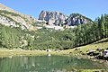
Brunnsteinersee and Rote Wand

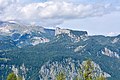
Brunnsteinerkar, Warscheneck and the surrounding mountains

The Hinterstoder slopes in March 2014


literature
- Gisbert Rabeder: Alpine Club Leader Dead Mountains . For hikers, mountaineers and climbers, Bergverlag Rudolf Rother , June 2005, ISBN 3-7633-1244-7