Grimming
| Grimming | ||
|---|---|---|
|
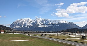
Northwest view of the mountain range |
||
| height | 2351 m above sea level A. | |
| location | Styria , Austria | |
| Mountains | Dachstein Mountains | |
| Dominance | 16.7 km → Kleiner Hochkasten | |
| Notch height | 1518 m ↓ Klachau | |
| Coordinates | 47 ° 31 '14 " N , 14 ° 1' 1" E | |
|
|
||
| rock | Dachstein Limestone | |
| Age of the rock | Triad | |
| First ascent | probably late 17th century | |
The Grimming is an isolated mountain range between the Ennstal and Hinterberger Tal in Upper Styria in Austria . He is counted to the Dachstein Mountains . Its highest peak ( 2351 m above sea level ) also bears the same name . The mountain range is also called Grimmingstock and the summit Hoher Grimming.
Location and shape
The Grimming extends over a length of about 9 km in a northeast-southwest direction from the Klachau to the breakthrough valley of the Salzabach with the Salza reservoir as the border to the Kemet Mountains below . Its width is about 4 km. In the northeast the Grimming rises steeply and reaches its greatest heights in the northeast half, while the ridge slopes gently to the southwest.
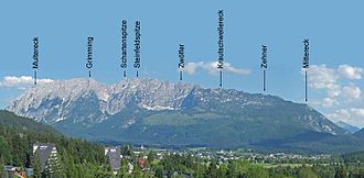
Striking heights from the northeast are Multereck (2176 m), Hoher Grimming (2351 m), Schartenspitze (2328 m), Steinfeldspitze (2290 m), Zwölfer (2146 m), Krautschwellereck (1959 m), Zehnerspitze (1879 m) and Mittereck ( 1695 m).
Between Hohem Grimming and Schartenspitze the ridge drops to 2159 m. To the south of the Hohe Grimmings there is a remarkable rock formation at a height of about 1630 m, the Grimmingtor, a 50 m high and 15 m wide wall depression that is closed by a 10 m thick rock overhang.
The Grimmings area is divided into three communities, Bad Mitterndorf in the north, Mitterberg-Sankt Martin in the south and Stainach-Pürgg in the east. The three municipal boundaries meet exactly on the Hohe Grimming.
The rock of the Grimmings is Dachstein limestone. The Grimming massif is forested up to a height of about 1500 m. There are no rivers worth mentioning in it. There is a stream called Grimming , but this has its origin over seven kilometers northeast in the Dead Mountains and grazes the Grimming when it falls through the Klachau into the Ennstal.
Probably because of its sudden ascent of 1700 meters from the Ennstal, the Grimming was formerly also known as "Mons Styriae altissimus", ie the highest mountain in Styria.
From the southeast via Irdning
Pürgg with Multereck
From the Tauplitzalm from
history
The earliest written evidence is from around 1286 and is "Grimei". The name goes back to the Slovenian grmeti (thunder, roar, roar) and originally only referred to the Grimming stream . The name was transferred to the parcel and the mountains.
It is not possible to determine who climbed the Grimming first. It was probably locals who possibly reached the summit while hunting. The Grimming was used as a survey symbol for national surveys very early on . In 1822, Lieutenant Carl Baron Simbschen set up a wooden survey sign on the summit and a stone hut just below it as a shelter. From the middle of the 19th century, numerous climbs followed from a mountaineering aspect with the exploration of various ascent routes.
The first summit cross, the seven-meter-high iron imperial cross, was erected on September 8, 1903 on the occasion of the 55th anniversary of the throne of Emperor Franz Josef I. It stood until 1954 and was replaced by a new one from the PES . There are now smaller crosses on several peaks.
Huts
- Grimminghütte (966 m): The only hut in this mountain range is located near the valley and can be reached from Trautenfels in about an hour.
- A bivouac box has been located north of the Grimming summit since 1949 , which can be used as emergency shelter in bad weather. It is equipped with an emergency telephone.
Climbs
- From Trautenfels through the snow pit (southeast): Most popular ascent via the Grimminghütte. This path was first taken in 1888 by Heinrich Hess .
- From Kulm (north-west): Starting behind the ski jumping hill, through the Gipfelkar, in which the bivouac box is located.
- From Trautenfels via Kasten and Multereck: Here you first cross the eastern pre-summit (2,176 m) before you come to the main summit.
- From Niederstuttern to the Grimminghütte, then left over the southeast ridge or right over Kasten and Multereck to the summit.
The grimming in literature
There are numerous legends about the Grimming, in which the Grimmingtor and the treasures hidden behind it play an important role. In addition to individual representations in larger collections, there are site-specific compilations on Grimming in the Ennstal Wiki and in a project on the Hinterberger Tal, in which both the historical background of the legends and their mythological interpretation are analyzed.
The novel “Das Grimmingtor” by the Austrian writer Paula Grogger (1892–1984), published in 1926, describes a family chronicle at the beginning of the 19th century, embedded in the landscape of the Grimmings.
Trivia
- In September 2011, 17 young men carried a Puch MV 50 moped (successor to the Puch MS 50 ) in individual parts up the Grimming, assembled it and started it.
- On August 31, 2013, a remarkable record was set on the Grimming. The Bad Mitterndorf band gave a short concert on the summit in full gear in front of around 500 listeners. Over 100 of the audience climbed up on foot like the musicians, the others by helicopter.
literature
- Josef Hasitschka, Ernst Kren, Adolf Mokrejs: The Grimming. Monolith in the Ennstal . Ed .: Universalmuseum Joanneum Schloss Trautenfels . 1st edition. Schall Verlag, Alland 2011, ISBN 978-3-900533-69-4 ( online ).
Web links
- Grimming stick. In: EnnstalWiki. Retrieved February 11, 2017 .
- High grimming. In: EnnstalWiki. Retrieved February 11, 2017 .
- Livecam of the community Sankt Martin am Grimming. Retrieved February 12, 2017 .
- Livecam of the Niederöblarn airfield. Retrieved February 12, 2017 .
Individual evidence
- ↑ a b OpenStreetMap. Retrieved February 11, 2017 .
- ↑ For example on the engravings by Georg Matthäus Vischer
- ↑ Fritz Frhr. Lochner von Hüttenbach: On the name property of the early Middle Ages in Styria (= magazine of the Historical Association for Styria . Volume 99 ). Böhlau Verlag, Vienna 2008, p. 39 ( historerverein-stmk.at [PDF; 16.9 MB ]).
- ^ Alfred Radio-Radiis: Dachstein Mountains and the adjacent areas. Artia, Vienna 1922, pp. 311-325 (online). ( Memento from February 13, 2017 in the Internet Archive )
- ↑ Kaiserkreuz am Grimming. In: EnnstalWiki. Retrieved February 11, 2017 .
- ↑ say about the Grimming. In: EnnstalWiki. Retrieved February 12, 2017 .
- ↑ The legendary Hinterbergertal. Retrieved February 12, 2017 .
- ^ Paula Grogger: The Grimmingtor . Styria Premium, 2014, ISBN 978-3-222-13439-5 .
- ↑ Curiosities. In: EnnstalWiki. Retrieved February 12, 2017 .
- ↑ The peak of brass music. In: Austria Forum. Retrieved February 12, 2017 .


