Salza reservoir
| Salza reservoir | |||||||||
|---|---|---|---|---|---|---|---|---|---|
| At the Salza reservoir | |||||||||
|
|||||||||
|
|
|||||||||
| Coordinates | 47 ° 29 '46 " N , 13 ° 57' 4" E | ||||||||
| Data on the structure | |||||||||
| Lock type: | Equiangular vaulted wall | ||||||||
| Construction time: | 1947-1949 | ||||||||
| Height of the barrier structure : | 53 m | ||||||||
| Building volume: | 22,000 m³ | ||||||||
| Crown length: | 121 m | ||||||||
| Crown width: | 3 m | ||||||||
| Base width: | 12 m | ||||||||
| Power plant output: | 8 MW | ||||||||
| Operator: | VERBUND Hydro Power AG | ||||||||
| Data on the reservoir | |||||||||
| Altitude (at congestion destination ) | 769 m above sea level A. | ||||||||
| Water surface | 80 ha | ||||||||
| Reservoir length | 5 km | ||||||||
| Reservoir width | 300 m | ||||||||
| Maximum depth | 50 m (mean depth 13.8 m) | ||||||||
| Total storage space : | 11 100 000 m³ | ||||||||
| Catchment area | 150 km² | ||||||||
| Particularities: |
Natural bathing lake, boat rental station; Fishing waters (closed); Landscape protection area |
||||||||
| Altitude full backlog 771 m above sea level. A. | |||||||||
The Salza reservoir is a dam system built between 1947 and 1949 on the Salzabach between Bad Mitterndorf and Sankt Martin am Grimming in the Liezen district in Styria .
Location and shape
The Salzabach, which comes from the Dead Mountains , drains the central part of the Hinterberger Valley . On its way to the Ennstal, it breaks through a canyon-like gorge as a valley pass, the eastern connection of the Dachstein massif ( Kemet mountains ) to the Grimming ( Stein pass ).
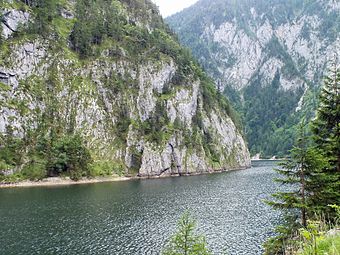
When the search for possible locations for new hydropower plants in Austria after the Second World War , the decision was also made for this site and sealed off the breakthrough valley on the southern side with a dam. This created an approximately 5500 meter long reservoir. This distance corresponds to the foot width of the rock massif. The lake is only about 80 to 150 meters wide and, especially in the southern part, it is lined with steep rock walls up to 500 meters high, which give it a fjord-like character. In the north, the bank boundary is flatter, like a mountain range . The lake is up to 50 meters deep.
The Pass-Stein-Straße (L729) runs along the west bank of the lake . After the lake was flooded, the path that used to run deeper in the valley had to be recreated. The road has been closed since 2003 due to the risk of rockslides and falling rocks. In the vicinity of the dam wall it leads past a small waterfall and a portrait of Mary.
Use and ecology
The Salza reservoir is used as a natural bathing lake (however, it is not designated as a bathing lake, as there is no water monitoring for bathing water quality ). There is a boat rental station near the north end of the lake, on the car-allowed part of the road.
Fishing is not allowed. In 2007 the lake was completely emptied for technical reasons. Relocation of the fish population was considered at the time, but rejected as too extensive. Therefore, the old stock of around 2500 kilograms of fish was completely used (and another 900 kilograms from the Salza below, which would also have had to be relocated due to the mud runoff), and the stocking with lake and brook trout , as well as with char was rebuilt. Around 70 percent of the perch that had been used when it was last fully emptied in 1974 contained around 70 percent of the harvested fish, which is atypically high for mountain waters. The revitalization of the habitat was called "a unique opportunity" at the time. There will be no fishing until the stock is consolidated.
The water quality is I – II, before the expansion of the sewage treatment plant in Hinterberg it was II – III (good to moderate).
The Salza reservoir is located in a conservation area ( Salzkammergut East , LS 14a ).
The power plant
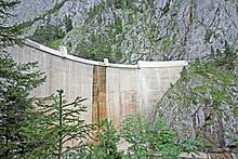
The dam of the power plant is an equiangular vaulted wall 53 meters high and 121 meters long. Their center is kept lower for the purpose of a defined flood overflow.
The power plant is located about 800 meters down the valley from the barrier wall. The headwater is led from the dam via a 320-meter-long pressure tunnel and a subsequent 470-meter-long pressure pipeline to the power plant's machine house. Here it drives a Francis spiral turbine with an impeller diameter of 1.45 meters at a nominal flow rate of 8600 liters per second, to which a three-phase synchronous generator with 8 MVA is coupled.
literature
- Specialist department 17C Unit water control of the Styrian state government: 1. Styrian lake report . Results of the limnological studies from 1999–2007 taking into account earlier publications, January 2008, 5. Der Salzastausee , pp. 123–144 ( pdf , Environment.steiermark.at).
Web links
- Storage power station Salza , verbund.com (with extensive technical data)
- Entry on Salza Stausee in the Austria Forum , author / editing: Hilde and Willi Senft, knowledge collection: A selection from the most beautiful lakes in Austria , Styria No. 17
proof
- ↑ Pass-Stein-Straße , in the Ennstal Wiki
- ↑ The spider in the Stein Pass , SAGEN.at >> Legendary Hinterbergertal , legend about the portrait of Mary
-
↑ Salza reservoir natural bathing lake , bergfex.at
salt reservoir east of the Dachstein , wissenswertes.at - ↑ Boat rental Salza reservoir , salzkammergut.at
- ↑ a b Salza reservoir is completely re-occupied . In: Kleine Zeitung online, October 1, 2007; Quote Matthias Pointinger, Austrian Federal Forests ( Memento from October 4, 2013 in the Internet Archive ) (open reading view)
- ↑ a b Lit. Seenbericht , p. 125 (pdf p. 127)


