Koppenwinkel lacquers
| Koppenwinkel lacquers | ||
|---|---|---|

|
||
| Geographical location | Upper Austria , Austria | |
| Tributaries | underground | |
| Drain | Overflow to Koppenwinklbach → Koppentraun / Traun → Danube → Black Sea | |
| Location close to the shore | Obertraun | |
| Data | ||
| Coordinates | 47 ° 33 '35 " N , 13 ° 43' 34" E | |
|
|
||
| Altitude above sea level | 524 m above sea level A. | |
| surface | approx. 2 ha | |
| length | 180 m | |
| width | 210 m | |
| Maximum depth | 0.5 m | |
|
particularities |
intermittently drying out |
|
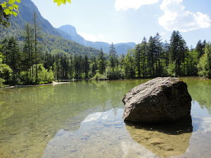
The Koppenwinkellacke is a karst body of water in the Koppenwinkel near the Koppenrast in the municipality of Obertraun in the Upper Austrian Salzkammergut .
The lake, actually a lacquer (pond) , located in the middle of alluvial forest , is about 200 meters long and divided by bays, as well as one larger and several smaller islands. The water depth is a maximum of half a meter. The water supply is exclusively underground. The water comes from the 840 km² Dachstein plateau , where it seeps through ponors and is only pushed into the lake by the impermeable rock layer through the gravel layer. If there are meter-high snow covers on the Dachstein massif in winter, the lake can dry out due to the lack of water supply. The lake last fell completely dry in autumn 2009. The overflow drains over the small Koppenwinklbach to the nearby Koppentraun .
The Koppenwinkellacke is about a 10 to 15 minute walk from the Obertraun-Koppenbrüllerhöhle train station and can be easily reached on foot or by bike.
The body of water, like the entire Koppenwinkel, has been under nature protection since 1978 and European protection since 2005 ( Dachstein nature reserve in the municipalities of Gosau, Hallstatt and Obertraun , N098 ; Dachstein European protection area ( FFH / BSG , AT3101000 / EU02 )) and has been part of the Core zone of the UNESCO World Heritage Site of the Hallstatt – Dachstein / Salzkammergut cultural landscape ( WHS 806 ).
proof
- Koppenwinkellacke Biotope No. 112; in: Wolfgang Diewald, Veronika Schleier (Red.): Natural space mapping Upper Austria: Biotope mapping community Obertraun. Final report, Office of Upper Austria. State government - Directorate for State Planning, Economic and Rural Development, Department for Nature Conservation / Natural Area Mapping Upper Austria, Kirchdorf / Krems, April 2012 ( report, pdf , land-oberoesterreich.gv.at - without data on biotopes in the electronic appendix).
- ↑ a b Information board at the Koppenwinkellacke
- ↑ this water also feeds Hagenbach : biotope mapping community Obertraun. Final report, p. 59
-
↑ therefore the groundwater body in the valley floor of Obertraun is probably not the feed; See biotope mapping of the municipality of Obertraun. Final report, p. 59;
Karst water in the Koppenwinkel ( page no longer available , search in web archives ) Info: The link was automatically marked as defective. Please check the link according to the instructions and then remove this notice. , obertraun.net - ↑ cf. biotope mapping community Obertraun. Figure 12: Koppenwinkel lacquer that has fallen dry , final report, p. 60.


