
Traun (Danube)


The Traun is a 153 km long right tributary of the Danube in Upper Austria ( Austria ). The mean discharge is 135 m³ / s, it drains most of the Salzkammergut . To the east of the Traun, the Traunviertel extends to the Enns .
etymology
The river name Traun is probably derived from the Celtic word druna ( the running one ). This river name was later adopted by the Romans.
geography
Run of the Traun
The Traun rises in Styria in the Dead Mountains as Grundlseer Traun in a source, the Traun origin behind the Kammersee , flows through the Toplitzsee and then the Grundlsee . Between Toplitzsee and Grundlsee the course is called Toplitz or Toplitzbach .
In Bad Aussee the Grundlseer Traun unites with the Altausseer Traun (from Altausseer See ) and is also called Badausseer Traun , officially the United Traun . Shortly afterwards, at Unterkainisch , the Kainischtraun (as Ödensee Traun from Ödensee and Riedlbach-Traun from Hochmühleck) flows into it, from here it is called Koppentraun . This upper catchment area (without Ödensee) is the Ausseerland as the northern part of the Styrian Salzkammergut . The Koppentraun flows westward through a gorge with the Koppenpass and a rail connection until it turns north on the Dachstein massif and feeds Lake Hallstatt .
It is only finally called Traun after it leaves the lake . In the middle course, initially called Goiserer Traun , it crosses the inner Salzkammergut and Bad Ischl , where it takes the Ischl from the Wolfgangsee , is called Ischler Traun and then Ebenseer Traun , and maintains the north-eastern direction. It flows along the Höllengebirge and at Ebensee into the Traunsee . After leaving the lake in Gmunden on the Traunstein , she is also called Gmundner Traun , leaves the Salzkammergut mountains and enters the Alpine foothills .
At Stadl-Paura it takes in the Ager from the Attersee , its largest tributary, and flows past Wels through the flat Welser Heide and touches the town of Traun . At the border between Ansfelden and Linz , a large part of the water volume at the Traun weir is diverted to the headwater canal that feeds the Linz-Kleinmünchen power plant .
The Traun flows into the Danube in the urban area of Linz , on the border between the districts of Pichling and the industrial area harbor (factory premises of voestalpine ) .

The origin of the Traun above the Kammersee
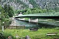
Traun Bridge at the outflow from Lake Hallstatt, Upper Austria

Outflow of the Traun from the Traunsee

Confluence of the Ager (coming from the west, right) into the Traun (coming from the south, center)
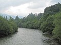
The Traun near Lauffen

The mouth of the Traun in Linz


Sections of the Trauntal
The valley of the Traun is clearly structured and comprises the following regions upstream:
- Lower Traun Valley from the Danube near Linz to Stadl-Paura, confluences of Alm and Ager, flat and hilly areas of the Welser Platte
- Traun Gorge to the Traunfall , a deepening section in the Ager-Traun Terraces of the Alpine foothills
- Middle Trauntal , between Traunsee and Hallstättersee, between Höllengebirge / Zimnitz and Traunstein Group to Bad Ischl, and Osterhorn Group and Totem Mountains upstream, comprises two basins with the Traunsee and Ischler Basin (Ischlerland) (spatial unit Salzkammergut Talungen - to which also the side valleys of the Ischl and the Gosaubach stream)
- Narrow valley of the Koppentraun , between the Dachstein massif and Sarstein
- Ausseerland with its source rivers and lakes, basin between the Dachstein massif and the Totem Mountains
The northern part of the Hinterberger Valley (upper Kainischtraun) is no longer Trauntal in the true sense of the word, and as a valley pass landscape is more likely to be part of the inner-Alpine Ennstal region .
Tributaries (downstream)
| Source rivers: Grundlseer Traun, Altausseer Traun, Kainischtraun | |
|
Left tributaries:
|
Right tributaries:
|
| and numerous other small streams in the course of the river | |
Water quality
The lower reaches of the Traun used to be very polluted by industry (e.g. the paper mills in Laakirchen) and the inflow of the heavily polluted Ager (chemical fiber pulp mill in Lenzing) and in parts only had grade IV. Today it has quality class I or II throughout the course, so you can see a few meters in Wels as well.
The upper course of the Koppentraun is a famous fishing lake that offers a natural river bed for several kilometers. The breakthrough of the Koppentraun is feared as a paddling water. The Traunfall near Steyrermühl is one of the few river diving spots for divers and snorkelers in Austria.
history

In Roman times, the Traun was navigated by flat barges from the Traunfall to its confluence with the Danube. The Traun was also very important for transporting salt and wood . The salt ships were originally sold as firewood and construction wood at their terminal port on the Danube, which, in addition to the brewing, contributed to a further increase in wood consumption in the Salzkammergut. In order to protect the forests from overexploitation, in 1509 Emperor Maximilian ordered the emptied salt barrels to be returned to their places of origin. The Traun farmers withdrew the Zillen from Zizlau (salt port on the Danube near Linz) to Stadl with their heavy horses . From here the return train to Gmunden was taken care of by the Roitham “Fallbauern” and from Ebensee to Hallstatt by the Ebenseer Rossbauern. With the return trains, food (mainly Hofkorn) for the miners and saltworkers was brought to the Salzkammergut. The shipping on the Traun is presented in the Schiffleutmuseum in Stadl-Paura .
In the Federal Army of the First Republic , under the leadership of Chief of Staff Field Marshal Lieutenant Alfred Jansa, plans to repel a German attack at the level of the Traun Line were worked out.
economy
Today the power plants on the Traun are particularly important.
( Bottleneck capacity and standard energy capacity according to information from the respective power plant operator. Status: 2005 and 2010)
| power plant | Bottleneck power (kW) |
Regelarbeits- assets (MWh / yr) |
operator | Note / pictures |
|---|---|---|---|---|
| Kainischtraun small hydropower plant | Austrian Federal Forests | |||
| Bad Aussee | 820 | 3,000 | Energie AG Upper Austria | |
| Lauffen | 100 | 750 | Energie AG Upper Austria | |
| Gmunden | 12,200 | 48,000 | Energie AG Upper Austria | |
| Kohl weir | ? | ? | UPM-Kymmene Austria GmbH (formerly Steyrermühl AG) |
|
| Factory turbine from UPM-Kymmene Austria GmbH (formerly Steyrermühl AG) |
? | ? | UPM-Kymmene Austria GmbH (formerly Steyrermühl AG) |
|
| Gschröff | ? | ? | UPM-Kymmene Austria GmbH (formerly Steyrermühl AG) |
|
| Siebenbrunn | ? | ? | UPM-Kymmene Austria GmbH (formerly Steyrermühl AG) |
|
| Traunfall | 9,850 | 58,000 | Energie AG Upper Austria | |
| Kemating | ? 1,500 | ? | UPM-Kymmene Austria GmbH (formerly Steyrermühl AG) |
|
| Stadl-Paura | 750 | 5,500 | Energie AG Upper Austria | |
| Lambach | 13,900 | 73,000 | Energie AG Upper Austria | |
| Breitenbach NEW | 2,700 | 13,700 | Wels Strom GmbH | |
| Traunleiten (municipality of Steinhaus) |
10,000 | 75,000 | Wels Strom GmbH | Will be rebuilt around 2019. |
| Marchtrenk | 42,800 | 173,000 | Energie AG Upper Austria | |
| Traun pucking | 45,800 | 215,000 | Energie AG Upper Austria | |
| Traunwehr | 1,300 | ? | Linz AG | |
| Linz Kleinmünchen | 10,000 | 70,000 | Linz AG |


Coat of arms with Traun motifs

catfish

Steinerkirchen

Fischlham

Stone house

Roitham am Traunfall

Laakirchen


The Traun has found its way into the coat of arms of several cities and communities that lie on the Traun. For example, the coats of arms of Wels (“green, wavy shield foot”), Steinerkirchen an der Traun (“ wavy band”), Fischlham (“golden wavy bar”), Steinhaus (“silver wavy bar”), Stadl-Paura , (“silver wavy bar "), Desselbrunn (" flank split by silver and blue ") and Laakirchen (" silver wave bar ") symbols for the Traun. The coat of arms of Roitham am Traunfall refers to the Traunfall with power plant and bridge.
literature
- The Traun - river without return , catalog for the exhibition in O.Ö. Landesmuseum Francisco-Carolinum from September 15, 1992 to March 14, 1993. Linz 1992, ISBN 3-900746-46-X
media
- The Traun - life path of a mountain river . Documentation, ORF Universum, directors: Erich Pröll, Klaus Feichtenberger, producer: Pröll Film Produktion GmbH
Web links
Individual evidence
- ^ Office of the Upper Austrian Provincial Government (Ed.): Traun, Investigations on Water Quality, Status 1991 . - Water protection Ber. 1/1992 ( PDF )
- ↑ Federal Ministry for Agriculture, Forestry, Environment and Water Management (ed.): Hydrographisches Jahrbuch von Österreich 2009. 117th volume. Vienna 2011, p. OG 183, PDF (12.1 MB) on bmlrt.gv.at (yearbook 2009)
- ↑ See Karl Vocelka: The house and farm names of the cadastral communities Altaussee, Grundlsee, Lupitsch, Obertressen, Reitern and streets in the Styrian Salzkammergut. Volume 1 (= dissertations from the University of Vienna 102). Association of Austrian Scientific Societies, Vienna 1974, p. 65f.
- ^ United Traun , entry digital water index Styria , wis.stmk.gv.at
- ↑ Fishing in the Goiserer Traun , oberoesterreich.at
- ↑ (Ebenseer + Ischler Traun) Hurch Revier , oberoesterreich.anglerinfo.at
- ↑ Gmundner Traun ( memento of March 4, 2016 in the Internet Archive ) , freundedergmundnertraun.at
- ↑ - Politics / Administration - Linz Figures - City Area (with an overview of the current and former statistical districts of Linz valid from 1957 to 2013), data status: January 1, 2019; accessed on December 29, 2019.
- ^ Office of Upper Austria. State government: water quality maps
- ↑ http://ooe.orf.at/news/stories/2612580/ Three safes fished from the Traun, ORF.at from November 2, 2013 (underwater pictures near Wels)
- ↑ Untertauern: New power plant opens on the Taurach salzburg24.at, July 15, 2019, accessed February 1, 2020.
- ↑ Homepage of Linz AG
- ↑ Homepage of Linz AG