Alm (river)
The Alm (or the Alm River ) is a 48 km long tributary of the Traun in Upper Austria .
Run and landscape
The Alm is the outflow of the Almsee north of the Dead Mountains and flows through the Almtal towards the north. It flows through Grünau in the Almtal , passes Scharnstein , Pettenbach , later Vorchdorf , Steinerkirchen an der Traun and Bad Wimsbach-Neydharting and flows into the Traun in the municipality of Fischlham . The average gradient is 5.3 ‰. Many larger and smaller tributaries turn the Alm into a broad mountain river with relatively cold water even in summer. The most important tributary, the Laudach , flows in the southern municipality of Bad Wimsbach-Neydharting from the left into the Alm.
In its course, the Alm first crosses the Northern Limestone Alps over a length of 17 km , then the Flysch Zone and finally the Molasse Zone to the confluence with the Traun with a length of 20 km .
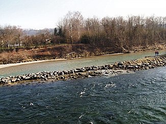
Between the Almsee and Grünau, the Alm represents a highly dynamic, pendulous mountain river, in the transition from the Alps to the Alpine foothills between Grünau and Mühltal it is a dynamically winding type of river, and in the Alpine foothills between Mühltal and the estuary it forms a furcating (forking) river system.
Catchment area and water supply
The natural catchment area of the Alm is 491 km². The highest point in it is the Great Priel at 2515 m above sea level. A.
The mean discharge is at the Grünau gauge, 36.9 km above the mouth, 9.24 m³ / s, at the Penningersteg gauge, 4.75 km above the mouth, 15.2 m³ / s, which corresponds to a discharge of 50.8 and respectively Corresponds to 34.1 l / (s · km²). The Alm has a clear winter runoff regime . The maximum discharge is during the snowmelt in spring, the month with the highest discharge is June with an average of 21.4 m³ / s, the minimum discharge in October is about half of that with 10.5 m³ / s.
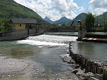
The outflow from the Almsee is controlled by a weir in such a way that the lake level is kept at a constant level with an inflow of over 1.5 m³ / s. Due to the diversion into mill streams and engine channels for the use of hydropower, the amount of runoff is reduced over long distances, with the river bed sometimes falling dry.
ecology
Between the Almsee and Grünau, the Alm has largely natural or near-natural banks. In the densely populated and agriculturally used area between Grünau and Vorchdorf, it is strongly regulated and forced into a straight river bed with accompanying dams. In the lower reaches it is surrounded by extensive, near-natural to natural riparian woods and riparian forests . The alpine meadows near Bad Wimsbach-Neydharting are designated as a nature reserve. In many places there are near-natural gravel banks . The river continuum is affected by around 50 weirs and other transverse structures, only a small part of which is passable for fish. The storage areas lead to a lower flow velocity and greater sedimentation .
flora
Along the upper alpine pasture, there are often species-rich riparian trees in which ash and sycamore are predominant. In the herb layer there are numerous limestone pointers such as liverwort , snow lily and lily of the valley , often mixed with species from the fresher, more nutrient-rich alluvial forests such as groundweed and wild garlic . Some of the trees on the banks were also planted, with various willows , gray and black alder , spruce and red pine being used. In the lower reaches the Alm is accompanied by riparian forests. These are mainly hardwood meadows consisting of ash, sycamore maple, common oak and winter linden . In many cases the alluvial forests have taken on the character of a mixed forest dominated by the spruce . Often, the riparian forests go beeches - mixed forests on, often extending to the valley flanks up to the shoreline. At Almau north of Scharnstein there are also extensive stands of yew trees . The pine alluvial forests in the Almauen nature reserve contain some very old red pines and some junipers that reach tree height . In the herbaceous layer, which is rich in species, there are numerous plants with a distribution focus in higher Alpine regions, as well as rare species such as the Turkish lily or lady 's slipper .
The gravel banks of the Alm are mostly sparsely overgrown with annual species and representatives of the ruderal flora such as Barbara's herb , shepherd's purse and chickweed , and there are also small trees and shrubs, mostly willows. The gravel banks in the upper and lower reaches have significantly more vegetation than those in the middle.
In the more calmly flowing areas of the alpine pasture, aquatic plants such as berle , river speedwell , hair-leaved water cockfoot and crested pondweed occur, while the marsh marigold can be found on the banks .
fauna
The Alm is a typical salmonid body of water . In the upper reaches it belongs to the trout region , in the middle and lower reaches to the grayling region , partly with elements of the barbel region . The most common species of fish are brown trout , brook trout , rainbow trout , grayling and Koppe , with brook trout and brown trout were used. Cyprinids such as barbel and minnow are rarely found in the alpine pastures ; species such as huchen , nasal and eel rods used to be found.
The banks of the mountain pasture are a breeding ground for several species of birds, including common golden spotted sandpiper , sandpiper and goosander . The population of the kingfisher , which used to breed frequently, has been greatly reduced due to bank protection and barriers. The black stork uses the lower alpine pasture to forage.
Very rare, highly specialized species of grasshopper, such as the gravel bank grasshopper and Turk's thorn insect, can be found on dynamic gravel banks . Some species such as the Boscis tender insect or the short-winged bite insect penetrate along the alpine pasture into the lower elevations of the Alpine foothills. The Alm near Scharnstein is one of the few places where the stonefly species Capnioneura nemuroides was found outside of the Alps.
Water quality
Due to the low population density and the comparatively small role played by agriculture and industry in the catchment area, the Alm is only slightly polluted and has water quality classes I-II over the entire course . The 500 to 1000 m wide groundwater stream accompanying the Alm represents an important supraregional drinking water reservoir.
Economic use

Since at least the 16th century the water power of the Alm has been used for mills , sawmills and scythe hammers . The water was mostly discharged via headrace channels or mill streams, which originally often represented side arms. Over the course of time, the scythe factories on the Alm became large companies in which all stages of production were combined, from production to grinding and packaging. They existed until the 19th century. The former Geyerhammer hammer mill in Scharnstein is now a museum. With the onset of industrialization , the first power station was built on the Alm in 1909 . Today, almost 60 small power plants generate electricity with a combined standard energy capacity of around 40,000,000 kWh per year.
Until the time after the First World War , the alpine pasture was used for logging and rafting . The tree trunks felled in the wooded areas of the upper reaches were transported over the Traun to the Danube. In order to always have enough water available for drifting, it was dammed with Klausen , which were opened when necessary. The weir systems were all equipped with raft lanes to enable continuous transport.
Surname
The name of the river is first mentioned in 791 as Albina . It is derived from Indo-European * albh- ("white", cf. Latin albus ) and denotes clear water. As the name " Elbe " shows, this type of name is common throughout Europe.
useful information
The Alm has found its way into the coat of arms of the Fischlham community . Together with the Traun, the Alm is represented as a wavy strip on the coat of arms.
The Almgasse was named after the Alm in 1953 in Vienna .
Web links
Individual evidence
- ↑ a b c d e f g h i j k l Office of Upper Austria. Provincial government, nature conservation department (ed.): Nature and landscape - models for Upper Austria. Volume 39: Lower Almtal room unit . Linz 2007 ( PDF; 867 kB ( Memento of the original from February 19, 2017 in the Internet Archive ) Info: The archive link has been inserted automatically and has not yet been checked. Please check the original and archive link according to the instructions and then remove this note. )
- ↑ Reinhard Wimmer: Flow order numbers, water system analysis and flow regime of the Traun. In: The Traun - river without return. Catalog of the Upper Austria. Landesmuseums, Linz 1992, Volume 2, p. 37 ( PDF on ZOBODAT ).
- ^ A b c Ministry for an Austria worth living in (ed.): Hydrographisches Jahrbuch von Österreich 2013. 121st volume. Vienna 2015, PDF (9.0 MB) on bmlrt.gv.at (2013 yearbook) - data and evaluations, p. OG 192-193 (PDF; 22.7 MB)
- ↑ These names were common until the 19th century, including the Danube River , and have been used in official publications to this day.
- ↑ a b c Office of the Upper Austrian Provincial Government (Ed.): Alm: Investigations on water quality, status 1991–1993. Water protection report 4/1993, Linz 1993 ( PDF (7 MB) on ZOBODAT ).
- ↑ Helmut Mader, Theo Steidl, Reinhard Wimmer: Discharge regime of Austrian rivers. Contributions to a nationwide river typology. Federal Environment Agency, Monographs Volume 82, Vienna 1996, p. 102 ( PDF; 14.7 MB )
- ↑ a b c Office of Upper Austria. Provincial government (ed.): Nature and landscape - models for Upper Austria. Volume 32: Salzkammergut-Voralpen spatial unit. Revised Version, Linz 2007, p. 40 ( PDF; 5 MB ( Memento of the original from December 22, 2015 in the Internet Archive ) Info: The archive link has been inserted automatically and has not yet been checked. Please check the original and archive link according to the instructions and then remove them Note. )
- ↑ Federal Ministry of Agriculture, Forestry, Environment and Water Management (ed.): Saprobiological water quality of the flowing waters of Austria. Status 2005. ( PDF; 1 MB ( Memento from October 19, 2013 in the Internet Archive ))
- ↑ Kleinwasserkraft Atlas von Kleinwasserkraft Österreich. www.kleinwasserkraft.at
- ^ Peter Wiesinger : Place names and settlement history in the Salzkammergut. In: Yearbook of the Upper Austrian Museum Association. Volume 149, Issue 1, Linz 2004, pp. 543-560 ( PDF (2.3 MB) on ZOBODAT ).


