Bad Wimsbach-Neydharting
|
market community Bad Wimsbach-Neydharting
|
||
|---|---|---|
| coat of arms | Austria map | |
|
|
||
| Basic data | ||
| Country: | Austria | |
| State : | Upper Austria | |
| Political District : | Catfish Land | |
| License plate : | WL | |
| Main town : | Wimsbach | |
| Surface: | 24.3 km² | |
| Coordinates : | 48 ° 4 ' N , 13 ° 54' E | |
| Height : | 387 m above sea level A. | |
| Residents : | 2,595 (January 1, 2020) | |
| Population density : | 107 inhabitants per km² | |
| Postal code : | 4654 | |
| Area code : | 0 72 45 | |
| Community code : | 4 18 03 | |
| NUTS region | AT312 | |
| Address of the municipal administration: |
Markt 1 4654 Bad Wimsbach-Neydharting |
|
| Website: | ||
| politics | ||
| Mayor : | Erwin Stürzlinger ( ÖVP ) | |
|
Municipal Council : (2015) (25 members) |
||
| Location of Bad Wimsbach-Neydharting in the Wels-Land district | ||
| Source: Municipal data from Statistics Austria | ||
Bad Wimsbach-Neydharting is a market town and health resort in Upper Austria in the Wels-Land district with 2595 inhabitants (as of January 1, 2020).
geography
Bad Wimsbach-Neydharting is 387 m above sea level in the Hausruckviertel or Traunviertel . The community belonged to the judicial district of Lambach until 2012 and has been part of the judicial district of Wels since January 1, 2013.
The extension is 5.5 km from north to south and 7.9 km from west to east. The total area is 24.3 km². 18.5% of the area is forested, 71.2% of the area is used for agriculture.
The responsible judicial district is Lambach .
Community structure
The municipality includes the following 13 localities (population in brackets as of January 1, 2020):
- Aigen (34)
- Au (322)
- Bachloh (119)
- Bergham (79)
- Dorfham (41)
- Ellnkam (72)
- Giering (55)
- Hague (107)
- Haidermoos (89)
- Koesslwang (171)
- Neydharting (244)
- Traun (63)
- Wimsbach (1199)
The community consists of the cadastral communities Au, Bachloh, Bergham, Kößlwang, Neydharting and Wimsbach.
Neighboring communities
| Stadl-Paura | Edt at Lambach | Fischlham |

|
Steinerkirchen | |
| Roitham am Traunfall | Vorchdorf |
coat of arms
Official description of the municipal coat of arms:
- Divided by red and blue raised by a silver bar studded with three silver plumes; below a golden bathing sheep covered with a black dog foot.
The municipality colors are blue-white-red.
The two parts of the coat of arms awarded in 1982 convey both the double name established in 1954 and the past and present of the market town through their images. Bars and plumes are taken from the (older) coat of arms of the Aspan von Liechtenhaag, which belonged to the Wimsbach rulership from 1446 until the end of the male line with the childless death of Hanns Joachim Aspan in 1645. The bath -creating refers to the cure in Moorbad Neydharting; the five-star-shaped pentagram drawn in one go is an old, magical, disaster-warding sign of salvation, already with the Pythagoreans an allegory of body and soul harmony and, based on this, also a symbol of health.
history
Already in the Hallstatt period there was a hilltop settlement on the Waschenberg within the angle of the mouth formed by the Alm and Traun .
Originally located in the eastern part of the Duchy of Bavaria, the place belonged to the Duchy of Austria since the 12th century . Since 1490 it has been assigned to the Principality of Austria ob der Enns .
During the Napoleonic Wars , the place was occupied several times.
Since 1918 the place belongs to the federal state of Upper Austria . After the annexation of Austria to the German Reich on March 13, 1938, the place belonged to the Gau Oberdonau . After 1945 the restoration of Upper Austria took place.
In 1954, the municipal council decided to rename the market town of Wimsbach to Bad Wimsbach-Neydharting . The name change should highlight the health resort with the medicinal and mud bath .
Culture and sights
Churches
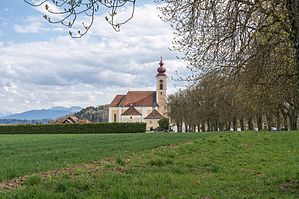
- Parish church St. Stephan in Wimsbach : The baroque country church was built between 1688 and 1691 by Carlo Antonio Carlone using parts of the previous Gothic church. The high altar from 1692 comes from the workshop of the Passau sculptor Johann Matthias Högenwald. The Way of the Cross from the workshop of the Wels painter Wolfgang Andreas Heindl (1693–1757) is unusually designed in an anti-clockwise direction.
- Affiliate Church of St. Thomas of Canterbury in the Wim
- Filial church St. Georg in Kößlwang (Gothic) with a valuable statue of St. George
Others
- Marketplace and town center with town houses
- hydropower-powered hoe forge (one of the oldest fully functional hoe forges in Europe)
- Moorbad Neydharting (Art Nouveau building) in the spa area open-air museum, Jungschützendenkmal, Neydhartinger Moor (nature reserve)
- Almauen nature reserve
- Villa Rustica (Roman excavation site) in the "Freydhofholz"
- Neydharting Castle
- Wimsbach Castle and Castle Park
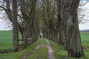
- 300 meter long Kastanienallee (unique)
- Views of Kösslwang, Bachloh and the Wim (here you can see the entire Upper Austrian Alpine chain)
- over 80 sacred small monuments (chapels, wayside shrines, ...)
Population development
In 1991 the municipality had 2,300 inhabitants according to the census, in 2001 it had 2,360 inhabitants.
Sports
In 1933 the Sport Klub Wimsbach was founded and is divided into seven sections. Football (1933), skiing (1970), gymnastics (1970), knitting (1972), tennis (1979), shooting (1982) and stick shooting (1983).
Web links
- Folder Kulturbegleiter Bad Wimsbach-Neydharting (PDF file; 401 kB)
- 41803 - Bad Wimsbach-Neydharting. Community data, Statistics Austria .
- Further information about the municipality of Bad Wimsbach-Neydharting can be found on the geographic information system of the state of Upper Austria .
Individual evidence
- ↑ Statistics Austria: Population on January 1st, 2020 by locality (area status on January 1st, 2020) , ( CSV )
- ^ Manfred Pertlwieser: The Hallstatt- era hilltop settlement on the Waschenberg near Bad Wimsbach-Neydharting, political district of Wels, Upper Austria. Part I: The facility. In: Yearbook of the Upper Austrian Museum Association. Volume 114a, Linz 1969, pp. 29-48 ( PDF on ZOBODAT ).
- ^ Hermann Vetters: The villa rustica of Wimsbach. In: Upper Austrian culture report. 1950, pp. 87-109 ( PDF on ZOBODAT ).


