Neukirchen near Lambach
|
Neukirchen near Lambach
|
||
|---|---|---|
| coat of arms | Austria map | |
|
|
||
| Basic data | ||
| Country: | Austria | |
| State : | Upper Austria | |
| Political District : | Catfish Land | |
| License plate : | WL | |
| Surface: | 11.85 km² | |
| Coordinates : | 48 ° 6 ' N , 13 ° 49' E | |
| Height : | 401 m above sea level A. | |
| Residents : | 935 (January 1, 2020) | |
| Population density : | 79 inhabitants per km² | |
| Postal code : | 4671 | |
| Area code : | 07245 | |
| Community code : | 4 18 13 | |
| NUTS region | AT312 | |
| Address of the municipal administration: |
Neukirchen bei Lambach Neukirchen bL 8 4671 Neukirchen bei Lambach |
|
| Website: | ||
| politics | ||
| Mayor : | Andreas Obermayr ( ÖVP ) | |
|
Municipal Council : (2015) (13 members) |
||
| Location of Neukirchen bei Lambach in the Wels-Land district | ||
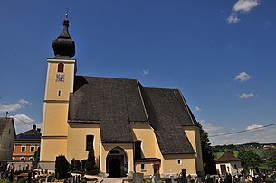
 Parish church Neukirchen near Lambach |
||
| Source: Municipal data from Statistics Austria | ||
Neukirchen bei Lambach is a municipality in Upper Austria in the Wels-Land district in the Hausruckviertel with 935 inhabitants (as of January 1, 2020).
geography
Neukirchen bei Lambach is 401 m above sea level in the Hausruckviertel. The community belonged to the judicial district of Lambach until 2012 and has been part of the judicial district of Wels since January 1, 2013 . The extension is 4.4 km from north to south and 4.6 km from west to east. The total area is 11.8 km². 11% of the area is forested, 78.8% of the area is used for agriculture.
Community structure
The municipality includes the following 15 localities (population in brackets as of January 1, 2020):
- Aming (22)
- Village (26)
- Industrial Park Neukirchen bei Lambach (0)
- Courtyard (56)
- Hofern (76)
- Iming (34)
- Löpperding (17)
- Neukirchen near Lambach (200)
- Hold down (7)
- Oberschwaig (196)
- Schörgendorf (19)
- Spöck (57)
- Stroham (52)
- Vineyard (129)
- Willing (44)
The community consists of the cadastral community Neukirchen bei Lambach.
Population development
In 1991 the municipality had 799 inhabitants according to the census, in 2001 it had 830 inhabitants.
coat of arms
Official description of the municipal coat of arms awarded in 1995: Above a hill of green and gold split by green and gold, square with a linden leaf cross in alternating colors. The municipality colors are yellow-red.
The two dominant basic colors of the coat of arms green and gold indicate the agricultural character of the municipality. The cross symbolizes on the one hand the joined church place name and on the other hand emphasizes Neukirchen as an incorporated parish of the Lambach monastery. The linden leaves at the ends of the cross are said to remind "speaking" of the most famous son of the place, one of the first dialect poets in Upper Austria, Maurus Lindemayr , who went far beyond local importance . The hill points to the 504 m high Krailberg, located on the northern border of the municipality, as the highest point in the Wels-Land district .
history
The name Neukirchen is mentioned for the first time in the documents of Lambach Abbey in 1070. Originally located in the eastern part of the Duchy of Bavaria, the place belonged to the Duchy of Austria since the 12th century. Since 1490 it has been assigned to the Principality of Austria ob der Enns .
During the Napoleonic Wars , the place was occupied several times.
Since 1918 the place belongs to the federal state of Upper Austria. After the annexation of Austria to the German Reich on March 13, 1938, the place belonged to the Gau Oberdonau . After 1945 the restoration of Upper Austria took place.
mayor
- 2001–2020 Franz Pühretmayr (ÖVP)
- from 2020 Andreas Obermayr (ÖVP)
Culture and sights
- Parish church Neukirchen near Lambach
- The Trachtenmusikkapelle Neukirchen bei Lambach was founded in 1890.
Personalities
Sons and daughters
- Maurus Lindemayr (OSB) (1723–1783), writer (plays)
Web links
- 41813 - Neukirchen near Lambach. Community data, Statistics Austria .
Further information about the community of Neukirchen bei Lambach can be found on the geographic information system of the federal state of Upper Austria .
Individual evidence
- ↑ Statistics Austria: Population on January 1st, 2020 by locality (area status on January 1st, 2020) , ( CSV )
- ^ A b Gertrude Paltinger: Mayor resigned and became an honorary citizen. In: tips.at. July 28, 2020, accessed July 28, 2020 .


