
Weißkirchen an der Traun
|
Weißkirchen an der Traun
|
||
|---|---|---|
| coat of arms | Austria map | |
 |
|
|
| Basic data | ||
| Country: | Austria | |
| State : | Upper Austria | |
| Political District : | Catfish Land | |
| License plate : | WL | |
| Surface: | 21.71 km² | |
| Coordinates : | 48 ° 10 ' N , 14 ° 8' E | |
| Height : | 305 m above sea level A. | |
| Residents : | 3,414 (January 1, 2020) | |
| Population density : | 157 inhabitants per km² | |
| Postal code : | 4616 | |
| Area code : | 07243 | |
| Community code : | 4 18 24 | |
| NUTS region | AT312 | |
| Address of the municipal administration: |
Gemeindeplatz 1 4616 Weißkirchen an der Traun |
|
| Website: | ||
| politics | ||
| Mayor : | Norbert Höpoltseder ( SPÖ ) | |
|
Municipal Council : (2015) (25 members) |
||
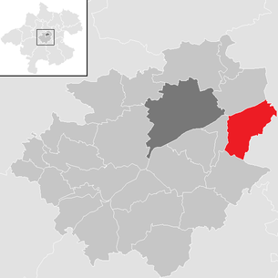
| Location of Weißkirchen an der Traun in the Wels-Land district | ||
  |
||
 Weißkirchen from afar |
||
| Source: Municipal data from Statistics Austria | ||

Weißkirchen an der Traun is a municipality in Upper Austria in the Wels-Land district in the Hausruckviertel with 3414 inhabitants (as of January 1, 2020). The responsible judicial district is Wels.
geography
Weißkirchen an der Traun is located at 305 m altitude in the Hausruckviertel . The extension is 6.2 km from north to south and 7.1 km from west to east. The total area is 21.8 km².
19.3% of the area is forested, 68.3% of the area is used for agriculture.
The Traun flows in the lower reaches on a widening gravel terrace in a fairly straight line and in the direction NE to ONE. Weißkirchen is consistently to the right of the Traun. The main town, the village of Weißkirchen, is about 1 km southeast of the river, at the foot of the first hill rising up on the right edge of the valley.
traffic
Several traffic axes run parallel to the Traun in the area: Westbahn, Landesstraße B1 to the left of the river, on which salt from the Salzkammergut used to travel downwards on rafts and where the Marchtrenk power plant has been damming since around 1980 , and to the right of the Traun is the "rear street" of Thalheim near Wels to Haid, where the Linz conurbation is already becoming much denser.
The Westautobahn runs a (hilly, sound-absorbing) piece south of Weißkirchen. For a long time between Sattledt (exit 195) and Haid (174) there was a relatively long section of 21 km with no regular descent. In the past, it was only possible to drive off the Allhaming car park informally (without signposting; local knowledge of the area and road maps that were common until the 1990s were used). Today there is a full connection to Allhaming (183), which arose from the old car park connections. A larger parking lot was built a little northeast of it.
Later the Welser Autobahn was added westward from the Haid node . Your full connection Marchtrenk-Ost / Weißkirchen (exit 9) is on the Traunbrücke between these two places.
Relevant railway stations for Weißkirchen are in Wels, Marchtrenk and Linz, as well as on the Kremstalbahn from Nettingsdorf to Rohr.
For bicycle traffic, a cycle route was built on the left along the Traun, where a towpath used to run.
The Linz-Hörsching Airport is located 15 kilometers by road to the northeast.
Community structure
The municipality includes the following localities (population in brackets as of January 1, 2020):
- Bergern (1209)
- Graßing (123), also Gem. Eggendorf
- Hetzendorf (166)
- Schimpelsberg (276)
- Sinnersdorf (193)
- Weißkirchen (1081), main town
- Weyerbach (366)
Cadastral communities are Grassing, Sinnersdorf, Weißkirchen, Weyerbach .
The only counting area is Weißkirchen an der Traun .
Neighboring communities
| Marchtrenk | Hörsching ( district Linz-Land ) ∗ | |
| Schleissheim |
.svg)
|
Pucking ( district Linz-Land ) |
|
Sipbachzell |
Eggendorf im Traunkreis ( district Linz-Land ) |
Allhaming ( district Linz-Land ) |
- ∗ Only at one point in the middle of the Traun
history
Little is known of the history of Weißkirchen from earlier centuries. A stone ax found suggests that people lived in the Weißkirchen area as early as the Stone Age. Unearthed remains of the wall show that settlements existed in Weißkirchen an der Traun during the Roman era. After the end of Roman rule, however, the area largely deserted again. It was only when Duke Tassilo founded the Kremsmünster Abbey in 777 that the monks of the monastery began to plant fields and meadows in what is now Weisskirchen.
In 1179 Wæizchirchen is in the Lateran charter of Pope Alexander III. Mentioned for the first time for the Kremsmünster Abbey. The name refers to the fact that a brick-built, white-colored church stood in Weißkirchen as early as the 12th century - in contrast to the wooden construction that was still widespread at the time. The parish of Weißkirchen was very extensive in the Middle Ages. In the 14th century, the parish encompassed the current parishes of Allhaming, Eggendorf, Weißkirchen, Pucking, as well as parts of Neuhofen, Schleißheim and Sipbachzell.
The rectory, which burned down in 1594, was rebuilt and subsequently enlarged and significantly embellished. The Weißkirchen rectory is not only worth mentioning because of its beauty, but also because of important historical events. On May 1, 1809, the later Field Marshal Radetzky came through Weißkirchen and stayed in the rectory, where a marble plaque commemorates this event. The next day, Emperor Napoleon and his troops traveled through Weißkirchen and were given a glass of water in the rectory. The glass Napoleon drank from is kept in the rectory to this day.
In 1857 a major fire broke out in what is now the Binder guesthouse and destroyed nine houses.
1883 The parish of Weißkirchen separates from the parish of Pucking. Pucking becomes a separate community.
1889 Establishment of the “advance fund association of the communities Eggendorf and Weißkirchen” according to the Raiffeisen principle, is considered the year of foundation of the Raiffeisenbank Weißkirchen, which is one of the oldest in the country.
1893 Eggendorf becomes an independent municipality.
In 1901, Weißkirchen received a gendarmerie post (old: Weißkirchen 50, Untere Dorfstrasse 5, the building no longer exists), which was closed on December 31, 1962.
After Austria was annexed to Hitler's Germany in 1938, the place belonged to the Gau Oberdonau . Around 100 concentration camp prisoners died on death marches through Weißkirchen in the last days of the war. A memorial in the Bergerner Au near the Weigl estate commemorates this.
After 1945 the state of Upper Austria was restored .
1952 Reconstruction of the Traun Bridge, which was blown up in 1945.
Population development
It is thanks to the good location of Weißkirchen (between Wels and Linz) that the community has received more and more immigrants in recent decades. The positive economic and traffic development in the central area also benefits Weißkirchen.

Source: Statistics Austria
politics

After the 2015 municipal council elections, the municipal council (25 members) was composed as follows: SPÖ 10, ÖVP 9, FPÖ 6.
mayor
- 1948–1967 Franz Leblhuber (ÖVP)
- 1967–1979 Alfred Staudinger (FPÖ)
- 1979-2008 Rudolf Prinz (SPÖ)
- since 2008 Norbert Höpoltseder (SPÖ)
Source: Weißkirchen an der Traun municipal office
coat of arms
- Divided by red and green by a silver cross with a silver cross that adjoins the upper edge of the shield and shortened double lintel rafters extending from the main shield ; at the bottom four silver discs crosswise .
The community colors are red-white-green.
The stylized "W" with a white cross on top symbolizes the place name. The four discs stand for the four cadastral communities of Graßing, Sinnersdorf, Weißkirchen and Weyerbach.
The municipality of Weißkirchen received the municipal coat of arms in 1985.
Culture and sights
- Catholic parish church:
- Klobinger Chapel: It was founded in 1864 as a foundation by the Klobinger farmers Dornauer (blacksmiths); Josef Neubauer (Bauer) and Josef Leblhuber (Huber) built. The Annen Altar, which is now in the parish church, was erected here until 1961. In its place the statue of the Virgin Mary from the neo-Gothic furnishings of the parish church was placed.
- Lurl: In 1980 the Lurl , a water point at the Pfarrhofgatter, was redesigned and declared a landmark (the fruit millstone comes from the Hansfischer Hof). Originally, these water points served the population as drinking and industrial water sources before a local water line was built. There are several similar water intake points in the center of the village.

Choir with decorations for Thanksgiving
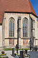
Frescoes at the end of the choir

Sgraffiti on the sacristy

Former children's grave

Rectory

Klobinger Chapel


societies
- Music band: founded in 1875
- Freiwillige Feuerwehr Weißkirchen: founded in 1889. The first armory of the FF Weißkirchen was located opposite the Gasthaus Staudinger (Obermayrplatz) and existed there until the mid-1960s. Later, after the establishment of the municipal office, it moved there - until 1991 an independent fire station was built on the former Heizinger site. There is only one trailer car left of the former “Weyerbach fire fighting train”.
- Sport Union Weißkirchen: Union Weißkirchen was founded in 1962. At that time it was still on the "Binder Wiesen", which the community of Weißkirchen acquired over the years. The tennis area was leased. The new Unionheim was opened in 2003, and in 2008 the old “club home” was torn down to make room for the stick shooters. "The Union" now includes the sections football, tennis and stick.
education
The parish of Weißkirchen housed one of the first elementary schools in the country (1596) in the rectory. In 1855 the elementary school was built near the parish church (Untere Dorfstrasse 7, Fam. Moisl), where it lasted until 1957. In 1957 the new elementary school was opened at its current location. 1971 New gymnasium, previously the place in front of the community team ("community forecourt") served as a gymnastics area. In 2003 the Volksschule.t was completely renovated
Web links
- Community website
- Entry on Weißkirchen an der Traun in the Austria Forum (in the AEIOU Austria Lexicon )
- 41824 - Weißkirchen an der Traun. Community data, Statistics Austria .
- Further information about the municipality of Weißkirchen an der Traun can be found on the geographic information system of the federal state of Upper Austria .
- Map in the Digital Upper Austrian Room Information System ( DORIS )
Individual evidence
- ↑ Statistics Austria: Population on January 1st, 2020 by locality (area status on January 1st, 2020) , ( CSV )
- ↑ a b Herbert Erich Baumert: The coats of arms of the cities, markets and communities of Upper Austria, 7th supplement (1984–1987) . In: Oberösterreichische Heimatblätter , Heft 4, 1988, p. 246 ( online (PDF) in the forum OoeGeschichte.at).
- ↑ M. Vyoral-Tschapka (2009): Austrian Art Topography Volume LVIII. Wels judicial district, publisher Bundesdenkmalamt; Horn: Verlag Berger. 986 ff.
- ↑ Source: Community Information Pucking.
- ↑ Festschrift RAIKA Weißkirchen, Raiffeisenkasse, 2000.
- ↑ A look at the community of Weißkirchen ad Traun (PDF; 35 kB)
- ^ Parish and community of Weißkirchen: Festschrift 800 years of the parish of Weißkirchen. 1. Weißkirchen Culture Days from 5. – 15. June 1980. Weiß Druck, Weißkirchen.
- ^ Union Weißkirchen: Festschrift 50 Years 1962–2012. Union Weißkirchen, 2012.

Aichkirchen | Bachmanning | Bad Wimsbach-Neydharting | Buchkirchen | Eberstalzell | Edt at Lambach | Fischlham | Gunskirchen | Holzhausen | Krenglbach | Lambach | Marchtrenk | Neukirchen bei Lambach | Offenhausen | Pennewang | Pichl near Wels | Sattledt | Schleissheim | Sipbachzell | Stadl-Paura | Steinerkirchen an der Traun | Stone house | Thalheim near Wels | Weißkirchen an der Traun
Cadastral communities: Grassing | Sinnersdorf | Weißkirchen | Weyerbach
Localities: Bergern | Graßing | Hetzendorf | Schimpelsberg | Sinnersdorf | Weißkirchen | Weyerbach
Villages: Haisching • Weißkirchen | Hamlet: Baching • Dörfl • Mittergraßing • Oberndorf • Untergraßing • Weitzendorf | Rotten: Buchet • Dietach • Klobing • Obergraßing • Sinnersdorf | Settlements: Bergern • Ecker grounds • Hetzendorf • Schimpelsberg settlement • Sinnersdorf settlement • Weyer | Scattered Houses: Grassing-Scattered Houses • Hetzendorf-Scattered Houses • Schimpelsberg • Weyerbach
Counting district: Weißkirchen an der Traun
