Sipbachzell
|
Sipbachzell
|
||
|---|---|---|
| coat of arms | Austria map | |
|
|
||
| Basic data | ||
| Country: | Austria | |
| State : | Upper Austria | |
| Political District : | Catfish Land | |
| License plate : | WL | |
| Surface: | 24.87 km² | |
| Coordinates : | 48 ° 6 ' N , 14 ° 7' E | |
| Height : | 366 m above sea level A. | |
| Residents : | 2,100 (January 1, 2020) | |
| Population density : | 84 inhabitants per km² | |
| Postal code : | 4621 | |
| Area code : | 07240 | |
| Community code : | 4 18 19 | |
| NUTS region | AT312 | |
| Address of the municipal administration: |
Municipality of Sipbachzell Hauptstrasse 29 4621 Sipbachzell |
|
| Website: | ||
| politics | ||
| Mayor : | Heinrich Striegl ( ÖVP ) | |
|
Municipal Council : (2015) (19 members) |
||
| Location of Sipbachzell in the Wels-Land district | ||

|
||
| Source: Municipal data from Statistics Austria | ||
Sipbachzell is an Austrian municipality in the Hausruckviertel in the Wels-Land district in Upper Austria with 2100 inhabitants (as of January 1, 2020).
geography
Sipbachzell is located at an altitude of 366 m in the Hausruckviertel .
The extension is 7.7 km from north to south and 6.4 km from west to east. The total area is 24.8 km². 15.7% of the area is forested, 77.4% of the area is used for agriculture.
Community structure
The municipal area comprises the following eight localities (population in brackets as of January 1, 2020):
- Giering (70)
- Leombach (539)
- Loibingdorf (78)
- Permannsberg (87)
- Rappersdorf (93)
- Schachermairdorf (124)
- Schnarrndorf (199)
- Sipbachzell (910)
The community consists of the cadastral communities Leombach, Schnarrendorf and Sipbachzell.
Neighboring communities
|
|
Weißkirchen an der Traun |
Eggendorf im Traunkreis ( district Linz-Land ) |
| Stone house |

|
Kematen an der Krems ( district Linz-Land ) |
| Sattledt |
history
A hoard from the late Bronze Age ( Urnfield Age ) that was found in Giering speaks for the prehistoric settlement of the municipality of Sipbachzell . The municipality is already at the turn of the 8th and 9th. Century, in the course of the Bavarian conquest , settled. Leombach Castle (largely dilapidated in the 18th century) is already mentioned in 777 when Duke Tassilo III. donated the area luibilinpach to Kremsmünster Abbey .
Sipachzell is mentioned as sippachcella 1179 (Bulle Pope Alexander III. ) For the church on Sipbach , as ' cell on Sipbach '. The latter stands for sip [p] en 'swampy, musty [smelling]' (compare siffig ), which refers to the swampy floodplain of the Middle Ages. This was drained for the timber industry under Abbot Gregor von Kremsmünster as early as 1555, the name has remained. Originally located in the eastern part of the Duchy of Bavaria , the place belonged to the Duchy of Austria since the 12th century . Since 1490 it has been assigned to the Principality of Austria ob der Enns .
Since 1918 the place belongs to the federal state of Upper Austria . After the annexation of Austria to the German Reich on March 13, 1938, the place belonged to the Gau Oberdonau . In 1945 Upper Austria was restored.
Population development
In 1991 the municipality had 1,480 inhabitants according to the census, in 2001 it had 1,713 inhabitants. On January 1st, 2005 the population was 1765.
politics
Constituency, judicial district
The community Sipbachzell belongs to constituency 3, the Hausruckviertel . The responsible judicial district is Wels .
Community representation
Distribution of seats since the municipal council election 2015:
- 11 mandates of the Austrian People's Party (ÖVP)
- 5 mandates for the Freedom Party of Austria (FPÖ)
- 3 mandates for the Social Democratic Party of Austria (SPÖ)
The mayor is Heinrich Striegl from the ÖVP.
coat of arms
Official description of the municipal coat of arms:
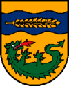
- In gold under a raised , blue wavy bar , inside a golden, lying Sipbachzeller original wheat ear , a green, lying on the back, upwardly curved, fire-breathing lindworm with red claws.
The municipality colors are yellow-red.
The Sipbach in the place name is represented by the blue wavy band in the upper half of the coat of arms. The wheat ear refers to the local origin and origin of the Upper Austrian regional varieties of common wheat in the area around Sipbachzell. The dragon establishes the relationship with St. Margaret, patron saint of the community and parish church.
education
- Kindergarten with day-care center and all-day care
- Elementary school
Culture and sights
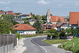
- Parish church Sipbachzell : The oneconsecrated to St. Margareta was built in 1478. The parish church is a late Gothic hall church with a net ribbed vault in the choir and nave that is well worth seeing. The 32 meter high tower is built in the style of a late Gothic fortified church.
- Moated Castle Leombach : In the Leombach district youcan still find the former longitudinal section, which was converted into a residential building, as well as the castle chapel of Leombach Castle
Personalities
Honorary citizen:
- Rudolf Vater (1882–1894), pastor of Sipbachzell
Daughters and Sons of the Church:
- Konrad Cordatus (around 1480–1546), Lutheran theologian and reformer
- Friedrich Krinzinger (* 1940), classical archaeologist
- Maria Santner (* 1986), dancer
Associated with the community:
- Marco Angelini (* 1984), singer, songwriter, doctor
Web links
- Community website
- Entry on Sipbachzell in the Austria Forum (in the AEIOU Austria Lexicon )
- 41819 - Sipbachzell. Community data, Statistics Austria .
- More information about the municipality of Sipbachzell on the geo-information system of the federal state of Upper Austria .
- Map in the Digital Upper Austrian Room Information System ( DORIS )
Individual evidence
- ↑ Statistics Austria: Population on January 1st, 2020 by locality (area status on January 1st, 2020) , ( CSV )
- ^ Peter Höglinger: The late Bronze Age depot find from Sipbachzell / Upper Austria. With a contribution by Jaroslav Frana and Lubos Jiran (= Linzer archaeological research. Special issue 16). Linz 1996, 31 pages.
- ^ Franz Sartori: The castle forts and knight castles of the Austrian monarchy . 2nd Edition. 7th part. Me. Lechner, Vienna 1839, The Leonbach Castle in Austria above the Enns , p. 164 ( Google eBook, full view ).
- ^ Benedikt Pillwein (Ed.): History, geography and statistics of the Archduchy of Austria on the Enns and the Duchy of Salzburg . With a register, which is also the topographical and genealogical lexicon and the district map. Geographical-historical-statistical detail according to district commissariats. 1st edition. Third part: the Hausruckkreis . Joh. Christ. Quandt, Linz 1830, Kremsmünster District Commissioner, Sipachzell Parish: Sipachzell, Sippachzell and footnote a), p. 369, p. 369 f ( Google eBook ). 2nd edition 1843 ( Google Book )
- ↑ Detailed description of the coat of arms , land-oberoesterreich.gv.at> Landesgeschichte


