
Steinhaus (Upper Austria)
|
Stone house
|
||
|---|---|---|
| coat of arms | Austria map | |
 |
|
|
| Basic data | ||
| Country: | Austria | |
| State : | Upper Austria | |
| Political District : | Catfish Land | |
| License plate : | WL | |
| Surface: | 25.12 km² | |
| Coordinates : | 48 ° 7 ' N , 14 ° 1' E | |
| Height : | 378 m above sea level A. | |
| Residents : | 2,268 (January 1, 2020) | |
| Population density : | 90 inhabitants per km² | |
| Postal code : | 4641 | |
| Area code : | 0 72 42 | |
| Community code : | 4 18 22 | |
| NUTS region | AT312 | |
| Address of the municipal administration: |
Gemeindeplatz 2 4641 Steinhaus |
|
| Website: | ||
| politics | ||
| Mayor : | Harald Piritsch ( FPÖ ) | |
|
Municipal Council : (2015) (19 members) |
||
| Location of Steinhaus in the Wels-Land district | ||
  |
||
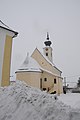
 View from the west of the stone house |
||
| Source: Municipal data from Statistics Austria | ||

Steinhaus is a municipality in Upper Austria in the Wels-Land district in the Traunviertel with 2268 inhabitants (as of January 1, 2020).
geography
Steinhaus is 378 m above sea level in the Traunviertel. The extension is 7.5 km from north to south and 6.1 km from west to east. The Aiterbach flows through Steinhaus . 9.2% of the municipal area is forested and 81.1% of the area is used for agriculture.
Community structure
The 6 localities are (population in brackets as of October 31, 2011):
|
|
Cadastral communities are Oberschauersberg and Steinhaus .
The only stone house counting district covers the entire community.
The Steinhaus community belongs to constituency 3, the Hausruckviertel . The responsible judicial district is Wels .
Neighboring communities
|
|
Catfish (hours) |
Thalheim near Wels |
.svg)
|
Sipbachzell | |
|
|
history
The place is first mentioned in the Kremsmünster Codex Fridericianus (originated between 1274 and 1325) as a branch church of the Thalheim monastery parish . Originally located in the eastern part of the Duchy of Bavaria , the place belonged to the Duchy of Austria since the 12th century . Since 1490 it has been assigned to the Principality of Austria ob der Enns .
During the Napoleonic Wars , the place was occupied several times.
Since 1918 the place belongs to the federal state of Upper Austria . After the annexation of Austria to the German Reich on March 13, 1938, the place belonged to the Gau Oberdonau . In 1945 Upper Austria was restored.
Population development
In 1991 the community had 1,734 inhabitants according to the census, in 2001 it had 1801 inhabitants.
politics
The municipal council has a total of 19 members. With the municipal council and mayor elections in Upper Austria in 2015 , the municipal council has the following distribution: 10 FPÖ, 6 ÖVP, 2 SPÖ and 1 GREEN.
- mayor
- 1945–1961 Johann Winetzhammer senior (ÖVP)
- 1961–1979 Alois Renoltner (ÖVP)
- 1979-2003 Lambert Haimbuchner (FPÖ)
- since 2003 Harald Piritsch (FPÖ)
coat of arms
Official description of the municipal coat of arms:
- Humiliated shared by blue and green; below a silver wavy beam , above a silver house with a golden roof.
The municipality colors are blue-white-black.
With the stone house is the arms talking the place name. The wave band is the Traun , which forms the municipal boundary in the northwest. The green color in the base of the shield indicates the agricultural character of the municipality with a high proportion of arable land and grassland.
Capital of the municipality
|
Steinhaus ( village ) locality ( capital of the municipality ) cadastral community Steinhaus |
|
|---|---|
| Basic data | |
| Pole. District , state | Wels-Land (WL), Upper Austria |
| Pole. local community | Stone house |
| Coordinates | 48 ° 6 ′ 56 " N , 14 ° 1 ′ 11" E |
| height | 378 m above sea level A. |
| Residents of the village | 1030 (January 1, 2020) |
| Building status | 216 (2001) |
| Area d. KG | 10.75 km² |
| Statistical identification | |
| Locality code | 13565 |
| Cadastral parish number | 51234 |
| Counting district / district | Stone house (41 822 000) |
| Ortsch. with Buchhof, slipway Source: STAT : Ortsverzeichnis ; BEV : GEONAM ; DORIS |
|
Municipal seat is the village stone house , which is also the village is the church. It is located about 7 kilometers south of Wels , in the center of the municipality. The place is at heights of around 380 m above sea level. A. in the valley of the Aiterbach , which flows into the Traun near Wels . Steinhaus extends today as a street village about 1800 meters in north-south direction along the Almtalbahn . In principle, the place is located directly on the Welser Westspange of the A8 Innkreis motorway , but is protected from noise pollution by a generous tunnel to the west. The village has a rural character with a few inns, a bank, a village shop, a butcher's shop as well as new settlements and many farms.
The village has around 220 buildings with a little over 650 inhabitants, that is about 1 ⁄ 3 of the community's population. This also includes the single location Buchhof out of the valley, and the houses northeast above the Riedel, on Seestraße and Hellingstraße to the hamlet of Helling , towards Thalheim .
The cadastral community Steinhaus with 1075 hectares also includes the villages of Oberhart and Unterhart to the south and east (of which districts also belong to Sattledt), and small parts of the village of Oberschauersberg to the north. The cadastral border within the municipality is the course of the Aiterbach.
- Neighboring towns and cities
| Oberschauersberg (O) |
Unterschauersberg (O, Gem.Talheim bW ) |
Bergerndorf (O, district Thalheim bW )
|
|
|
Thal (Gem. Thalheim bW ) |
|
|
Schörgendorf Dorf |
Matzelsdorf | Unterhart (O, Gem. Steinhaus and Sattledt ) |
Culture and sights
- Parish church stone house with cemetery: The current church was built in 1683. The baroque high altar from 1693 bears statues by Johann Baptist Carlperger . In 1793 the west tower was expanded with an onion helmet.
- Filialkirche Taxlberg : late Gothic simple rectangular building; Single-nave, three-bay nave with ribbed vaults, ribbed vaults in the choir. The wood-covered open porch in front of the late Gothic west gate with iron fittings was probably used earlier to bless domestic animals.
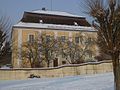
- Steinhaus Castle : Polhaimer castle from the 13th century at the latest, rebuilt as a country castle after a fire in 1766. Privately owned.
- War memorial on the western castle park wall
- Antonius monument at Steinhaus Castle
Steinhaus parish church
Rectory stone house

Antonius monument at Steinhaus Castle


Steinhaus has a 4.57% share of the area in the Natura 2000 protected area Untere Traun , in which the Traunleiten power plant is also located and may be rebuilt with the approval of the nature conservation authority from March 2016.
Economy and Infrastructure
Established businesses
- The industrial plant construction company Kremsmueller is based in Steinhaus.
- The Traunleiten diversion power plant of the E-Werk-Wels (EWW, Wels Strom) is to the right of the Traun in Steinhaus. First erected in 1899/1900, it was demolished beginning in autumn 2017 and is expected to be 100 m further and a few meters lower by November 2019. The diversion channel from the Welser weir is partially widened, the energy production is to be almost doubled to 90 GWh in the normal year.
Personalities
- Peter Pirquet von Cesenatico (1781–1861), Imperial and Royal Feldzeugmeister and knight of the Military Order of Maria Theresa
- Anton von Eiselsberg (1860–1939), university professor of medicine and surgeon of international standing
- Johann Winetzhammer (1925–1986), politician ( ÖVP )
- Manfred Haimbuchner (* 1978), politician ( FPÖ )
literature
- Steinhaus community: Steinhaus near Wels. History - culture - small monuments. Verlag Moserbauer, 2001, ISBN 978-390212109-7 .
Web links
- Community website
- Entry on Steinhaus in the Austria Forum (in the AEIOU Austria Lexicon )
- 41822 - Steinhaus (Upper Austria). Community data, Statistics Austria .
- Further information about the municipality of Steinhaus (Upper Austria) can be found on the geographic information system of the federal state of Upper Austria .
- Map in the Digital Upper Austrian Room Information System ( DORIS )
Individual evidence
- ↑ Statistics Austria, register census from October 31, 2011
-
↑ a b Herbert Erich Baumert: The coats of arms of the cities, markets and communities of Upper Austria, 9th (last) addendum 1992–1996 . In: Oberösterreichische Heimatblätter , Heft 3, 1996, p. 251 ( online (PDF) in the forum OoeGeschichte.at).
Detailed description of the coat of arms , land-oberoesterreich.gv.at> Landesgeschichte - ↑ Authority gives the green light for Kraftwerkbau nachrichten.at, March 31, 2016, accessed December 16, 2018.
- ↑ W. Weißmair, M. Pollheimer, A. Schuster: management plan for the European nature reserve "Lower Traun" AT3113000 On behalf of the Conservation Department, Office of the Upper Austrian government. 2011. Retrieved December 16, 2018.
- ↑ Andreas Pointinger: Replacement of the Traunleiten power plant in Upper Austria is making rapid progress zek.at, August 31, 2018, called on December 16, 2018.

Aichkirchen | Bachmanning | Bad Wimsbach-Neydharting | Buchkirchen | Eberstalzell | Edt at Lambach | Fischlham | Gunskirchen | Holzhausen | Krenglbach | Lambach | Marchtrenk | Neukirchen bei Lambach | Offenhausen | Pennewang | Pichl near Wels | Sattledt | Schleissheim | Sipbachzell | Stadl-Paura | Steinerkirchen an der Traun | Stone house | Thalheim near Wels | Weißkirchen an der Traun
Cadastral communities: Oberschauersberg stone house
Locations: Oberhart | Oberschauersberg | Stone house | Taxlberg | Traunleiten | Under hard
Village: stone house | Hamlet: Village • Gaisberg • Helling • Kammerberg • Matzelsdorf • Pesendorf (near Traunleiten) • Pesendorf (near Unterhart) • Schörgendorf • Siebmaiern • Straß | Rotte: Aiterbach • Scattered houses: Oberhart • Oberschauersberg • Taxlberg • Traunleiten • Unterhart
Counting district: stone house

Sacred and profane architectural monuments: Catholic Filialkirche hl. Nicholas and former cemetery area | Catholic parish church Alle hll. Apostle and former cemetery | War memorial | Light column | So-called. Plague column | Rectory and outbuildings | Steinhaus Castle with statue of St. Anthony of Padua and garden wall
Archaeological monuments: Roman Villa Traunleiten