
Traunviertel
Coordinates: 47 ° 50 ' N , 14 ° 5' E

| Quarter and districts of Upper Austria |
|---|
 |
The Traunviertel (in municipality names also Traunkreis ) is the landscape of the southeast of Upper Austria . It is named after the Traun river , which originally formed the north-western boundary of this part of the country from Upper Austria.
Traditional part of the country
The region is derived from the medieval Traungau .
Since the formation of the political districts in 1868, the quarters in Upper Austria no longer have a legal basis and are purely landscape names. The older district division , which was still based on the old quarters, was replaced.
The south-eastern part of the Traunviertel borders the Tennengau in the south-west, the Liezen district in the south and the Mostviertel in the east .
Transferred to today's administration, the quarter comprises the following political districts :
- Gmunden
- Church Village
- Steyr-Land
- Steyr city
- Linz (right of the Danube)
- Linz-Land (right of the Traun)
- Wels-Land (right of the Traun)
NUTS breakdown: AT315
In the official statistics of EU guided NUTS headings from is Traunviertel otherwise defined, and is one of five groups of districts (level NUTS: AT -2) in Upper Austria, carries the code AT315and areas comprising Gmunden and Vöcklabruck , was thus reduced and extends further west.
The eastern parts of the traditional Traunviertel form the NUTS region Steyr-Kirchdorf , the north -eastern parts belong to Linz-Wels . This also corresponds to the modern spatial planning concept in which the Upper Austrian central area is singled out as the "fifth" quarter.
history
Originally the area of the Traunviertel, the Traungau , was owned by the Traungau Counts, the Otakare , and until 1254 it belonged to the Duchy of Styria . With the Treaty of Ofen 1254 between Ottokar II. Přemysl and the Hungarian king Béla IV. , The area was separated from Styria and became the heart of what is now Upper Austria.
photos

The Traunsee with the Höllengebirge in the Salzkammergut

The Gosau valley

Scharnstein ruins in the Almtal

Landscape near Kirchdorf an der Krems with the Krems wall
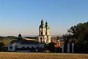
View from St. Florian Monastery to the Florianer Landl

The Gaflenz Valley
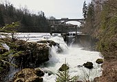
The Traunfall at Roitham
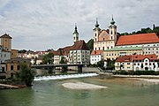
The confluence of the Steyr in the Enns in Steyr


.JPG)

See also
Web links
- Overview map of the quarter borders (PDF; 0.34 MB) on DORIS
- Overview map of historical quarter borders (until 1849) (PDF; 1.3 MB) on DORIS
- Classification of NUTS III regions in Upper Austria
Individual evidence
- ↑ For background information on Eurostat's NUTS classification, see Background. NUTS - Nomenclature of territorial units for statistics. Eurostat , accessed February 8, 2020 . NUTS classification in direct download (Excel, 527 KB)
Innviertel |
Mühlviertel |
Hausruckviertel |
Traunviertel
Upper Austrian central area ("5th quarter")
NUTS: AT-1 group of federal states : AT1 Eastern Austria • AT2 Southern Austria • AT3 Western Austria
NUTS: AT-2 federal states : AT11 Burgenland • AT12 Lower Austria • AT13 Vienna • AT21 Carinthia • AT22 Styria • AT31 Upper Austria • AT32 Province of Salzburg • AT33 Tyrol • AT34 Vorarlberg
NUTS: AT-3 group of districts : AT111 Mittelburgenland • AT112 Northern Burgenland • AT113 Southern Burgenland • AT121 Mostviertel-Eisenwurzen • AT122 Lower Austria-South • AT123 St. Pölten • AT124 Waldviertel • AT125 Weinviertel • AT126 Vienna region / northern part • AT127 Vienna region / southern part • AT130 Vienna • AT211 Klagenfurt-Villach • AT212 Upper Carinthia • AT213 Lower Carinthia • AT221 Graz • AT222 Liezen • AT223 Eastern Upper Styria • AT224 Eastern Styria • AT225 Western and Southern Styria • AT226 Western Upper Styria • AT311 Innviertel • AT312 AT314 Mühlviertel • AT312 Linz-Wels Steyr-Kirchdorf • AT315 Traunviertel • AT321 Lungau • AT322 Pinzgau-Pongau • AT323 Salzburg and surroundings • AT331 Ausserfern • AT332 Innsbruck • AT333 East Tyrol • AT334 Tiroler Oberland • AT335 Tiroler Unterland • AT341 Bludenz-Bregenz Forest • AT342 Rheintal-Bodensee region
LAU: AT-1 not occupied