
Traunfall

.jpg)
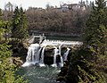
The Traunfall is a waterfall on the Traun in Upper Austria . It is located between the two towns of Steyrermühl and Roitham on the Traunfall , on the municipal border between Desselbrunn and Roitham. The waterfall has a height of about twelve meters and is several times the width of the river bed. On a river stretch of around 200 meters, the fall runs diagonally from the left bank of the river to the right.
In the course of the construction of the “Traunfall” power plant around 1900, the “wild fall” was greatly changed by a concrete weir system and the fall channel for the raftsmen , also known as the “good fall”, was eliminated.
Fall canal

Due to the gradient, the Traunfall was a natural obstacle to shipping for a long time. It was made navigable for the first time in 1311. What this construction looked like is no longer known today. It was not until the 16th century that the permanent “mobile fall” or “good fall”, as it was also called, came about through the sustained expansion of the canal, known as the Neue Fahrt , downstream of the old falls . This was built by the timber, Klaus and hydraulic engineer Thomas Seeauer from Bad Goisern .
The boat lane of the Fall Canal was 396.5 m long and varied in width, an average of 6.1 m. The slope of the canal was also not uniform, it was 15 ‰ at the beginning and 65.7 ‰ at the end. In order to reduce the water speed in the boat lane with increasing and towards the end very steep gradient, slots were left in the wooden floor of the channel . Therefore the water level was 90 cm at the beginning and only 30 cm at the exit. The passage through this raft lane took 54 seconds and was very risky with the resources at the time. A model of the entire system can be viewed in the Schiffleutmuseum in Stadl-Paura .
Today nothing is left of the Fall Canal. Like many wooden buildings on and on the Traun , it was a victim of modernization. Today an underground watercourse runs along the old canal, with which the Traunfall hydropower plant is operated. The artificial rock wall and some metal struts are still preserved today.
Picture gallery

The Traunfall in Upper Austria (painting by JN Schödlberger , around 1820)

The Traunfall (photo from 2012)
The Traunfall at the lower end of the weir system

The Traunfall in the middle area in the direction upstream

The Traunfall at the top of the weir system

.JPG)
.JPG)
.JPG)
.JPG)
Traunfall and Siebenbrunn power plants
From the last quarter of the 19th century, the Traun was used for the electricity industry, among other things, at the turn of the century the most important power plant of the Traun at the Traunfall was built. It was built by the Stern & Hafferl company , which (also) operated the local railways nearby - and still operates it today. In 1901 the power plant went into operation with an output of 1830 kW . An expansion took place as early as 1903, so that the power plant delivered 2,740 kW. At that time it was one of the largest hydropower plants in Austria. The power plant operation was taken over by OKA and received a new, more powerful machine set, which more than doubled the bottleneck output and is still 8800 kW. The operator today - renamed - is Energie AG Oberösterreich .
The power house of the Traunfall power plant is about 500 m after the start of the Traunfall. Another hydroelectric power plant - Siebenbrunn power plant - was built by the Steyrermühl paper mill about 250 m above the Traunfall in 1923 . For the first time, two Kaplan turbines with an output of over 1000 hp each were used. These turbines are still in operation and are the oldest Kaplan turbines in use in the world. The plant was also taken over by Energie AG in 2017.
Traunfall Bridge

The first Traunfall Bridge led across the river at the lower end of the Traunfall. In 1925 a reinforced concrete arch bridge with a span of 71 meters and a height of around 28 meters was built upstream at the edge of the valley according to a design by the architect Julius Schulte ; at that time it was the largest arch bridge in Austria. This bridge was destroyed during the Second World War and rebuilt in its old form in 1948.
Nikolauskapelle at the Traunfall

In 1439 the chapel on the fall was first reported. In 1598 it was washed away by floods and only 100 years later was it rebuilt in its baroque form, which has been preserved to this day. For centuries, the respective Roitham pastor had to celebrate a weekly mass in this chapel. This fair was donated by the Gmund salt makers. Today the chapel is one of the last remaining buildings on the Traunfall from the time of the salt shipping and is a listed building.
Rafting Madonna

Based on a design by the Ebenseer sculptor Johann Kienesberger, Josef Prizovsky made a bronze sculpture with the designation "Rafting Madonna" about 130 × 100 cm (H × W). This work of art was erected in 1984 on a stone plinth on the right bank of the Traun, in the area of the original Traun crossing, where a footbridge now leads over the Traun. In August 2012 the bronze statue was stolen by unknown perpetrators.
Web links
Individual evidence
- ^ Energie AG: Power plant levels of the middle and lower Traun. ( Memento of the original from February 28, 2014 in the Internet Archive ) Info: The archive link was inserted automatically and has not yet been checked. Please check the original and archive link according to the instructions and then remove this notice. (PDF, 636 kB; accessed March 30, 2012).
- ↑ Martin Gschwandtner: Viktor Kaplan and his turbine. Publishing house for academic texts, ISBN 9783638166621 ( limited preview in Google book search).
- ↑ a b Energie AG took over five paper mill power plants on the Traun. In: Oberösterreichische Nachrichten online (nachrichten.at), August 2, 2017.
- ↑ Franz Federspiel: River control and hydraulic engineering on the Traun (catalogs of the Upper Austrian State Museum NF No. 54, 1992, 185–204; PDF; 2.5 MB)
- ↑ Federal Criminal Police Office : Statue of the raftsman Madonna retrieved on September 9th. 2012, not available June 20, 2020.
Coordinates: 48 ° 0 '58 " N , 13 ° 47' 59" E