
Kremsmauer
| Kremsmauer | ||
|---|---|---|
 Kremsmauer from the east |
||
| height | 1604 m above sea level A. | |
| location | Upper Austria , Austria | |
| Mountains | Upper Austrian Pre-Alps | |
| Dominance | 8.1 km → Kasberg | |
| Notch height | 658 m ↓ water soils | |
| Coordinates | 47 ° 50 '39 " N , 14 ° 6' 1" E | |
|
||
| rock | Wetterstein lime | |
| Normal way | West Ridge ( II ) | |
| particularities | Triple point Alm – Krems – Steyr ⊙ | |

The Kremsmauer belongs with the highest elevation of 1604 m above sea level. A. on the mountain range of the northern pre-Alps in Upper Austria .
It lies between the Almtal , the Kremstal and the upper Steyrtal . Neighboring communities are Klaus with the village of Steyrling , Grünau , Micheldorf and Steinbach am Ziehberg .
At the foot of the wall, on the northeast side that springs Krems in Krems origin . The south-eastern extension of the Kremsmauer is the Kirchmauer , with the Brennet ( 1249 m above sea level ) as the summit. The north-western continuation, bordering the Törl ( 1457 m above sea level ) is called the Falkenmauer (main summit 1569 m above sea level ). On the ridge between the main summit and Törl is the triple point Alm –Krems– Steyr (approx. 1550 m above sea level ), the first two rivers go to the Traun , the latter to the Enns .
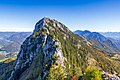
Kremsmauer, seen from the Törlspitze ( 1510 m )
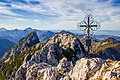
Summit cross of the Kremsmauer ( 1604 m )

Summit cross of the pyramid ( 1599 m ), a secondary summit of the Kremsmauer
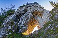
The Törl, a rock gate between Kremsmauer and Falkenmauer


panorama

Web links
proof
- Gerald Radinger: Kalkalpen National Park. The most beautiful tours between Enns and Steyr. 2nd edition, Verlag Kral, Berndorf 2012, ISBN 978-3-99024-066-3 , p .oA