
Steyr (river)
| Steyr | ||
 |
||
| Data | ||
| location | Upper Austria | |
| River system | Danube | |
| Drain over | Enns → Danube → Black Sea | |
| source | Baumschlagerreith in Hinterstoder 47 ° 38 ′ 16 ″ N , 14 ° 4 ′ 57 ″ E |
|
| Source height | 850 m above sea level A. | |
| muzzle | in Steyr coordinates: 48 ° 2 ′ 33 " N , 14 ° 25 ′ 18" E 48 ° 2 ′ 33 " N , 14 ° 25 ′ 18" E |
|
| Mouth height | 290 m above sea level A. | |
| Height difference | 560 m | |
| Bottom slope | 8.2 ‰ | |
| length | 68 km | |
| Catchment area | 917.35 km² | |
| Discharge at the Pergern A Eo gauge: 898.1 km². Location: 5.43 km above the mouth |
NNQ (01/28/1961) MNQ 1951–2010 MQ 1951–2010 Mq 1951–2010 MHQ 1951–2010 HHQ (08/12/2002) |
3.3 m³ / s 9.72 m³ / s 36.4 m³ / s 40.5 l / (s km²) 354 m³ / s 899 m³ / s |
 Steyr origin in the Stodertal |
||
The Steyr ( ) is a river in the Upper Austrian region of Pyhrn-Eisenwurzen , which rises in the Totes Gebirge near Baumschlagerreith in Hinterstoder ( Kirchdorf an der Krems district ) and after around 68 km in the city of Steyr from the left flows into the Enns .
geography

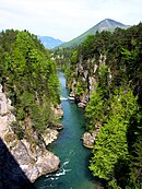
In the upper reaches the Steyr flows through the Stodertal. Below the Steyrsberg , the valley narrows and the river flows over the Stromboding waterfall . From the Steyrbrücke the path of the Steyr leads through a deeply cut gorge that has been flooded by a dam near Klaus since 1975 . The resulting Klauser See is used as a recreational area in addition to generating energy. The right bank of the lake is part of the Kalkalpen National Park .
Below the pilgrimage church Frauenstein in the Mollner district of Ramsau there is another rock gorge, the so-called Steyr breakthrough . At the beginning of the gorge is the Steyrbruchbruch power plant , which is known for its Art Nouveau architecture. After Steyr breakthrough expands the Steyrtal to Mollner pool, in the gravel terrace Steyr has cut deep.
The Steyr breakthrough from Talübergang the B 140 seen from

A trickling wall near Molln


Below the mouth of the Krumme Steyrling near Molln is the Rinnende Mauer , a rare spring of eaves . Water escapes from porous conglomerate rock five to seven meters above river level in the form of drizzling rain. This is accumulated groundwater and slope water. In this section of the gorge there are high mountain plants up to 400 m above sea level, such as hairy alpine rose , dwarf galpenrose , Petergstamm , hunter's blood or hairy Germer .
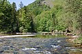
At Leonstein (municipality of Grünburg ) the valley narrows again. The Steyr then reaches the Alpine foothills via Grünburg . At Sierning , the river, which was previously flowing north or northeast, changes its direction of flow to the east. In the city of Steyr, the river gives off some of its water to the weir ditch , which many companies used to use to generate energy. At the confluence with the Enns, both rivers form a “Y” that the city of Steyr uses for marketing purposes.
Emergence
The drainage network of the Danube , to which the Steyr with tributaries and tributaries belongs, was created in the course of the alpine mountain formation about 100 million years ago. Probably even before the Minde Ice Age (600,000 to 300,000 years ago) the watershed at the Steyr breakthrough was so low that the Steyr river could "break through". Before that, it flowed through what is now the Kremstal . The current course of the river has been formed since the end of the Würm Ice Age around 11,000 years ago. The old valley gully to the west of it is filled with glacier gravel and instead the river sank into the dolomite rock in a so-called epigenetic breakthrough .
The gorge systems of the Steyr and its tributaries Teichl and Krumme Steyrling are 30 to 40 meter high, partly overhanging, conglomerate walls . To this day, the rivers are deepening into the glacier rubble.
Pictures of the middle course and estuary

Gorge section in Leonstein (left) and Molln (right)
Steyr in Leonstein

Overgrown gravel bank

Estuary of the Krumme Steyrling

Estuary into the Enns


Economical meaning

The Steyr was and is mainly used to generate energy. Formerly used to drive mills or forging hammers directly, for example, and later to generate electricity.
Until 1890, the river was used with board rafts called Ladenkarl . These rafts were on average 5 m long, 4 m wide and 50 cm high and could be steered by one man. They were mostly taken apart in Steyr, but sometimes they were tied together to form longer rafts to continue on the Enns. The table sign of the shopkeeper in the museum of the city of Steyr shows a model of such a raft in a Ein'gricht ( patience bottle ).
Up until the end of the Second World War, the Holztrift played a role as a means of transport for sawmills on the Steyr and its tributaries . Every year from March to the end of November, around 30,000 cubic meters were drifted on the river, for this reason older weirs (such as the Steyr breakthrough) are equipped with drift alleys.
Power plants
( Bottleneck capacity and standard energy capacity according to the information provided by the respective power plant operator. Status: 2011)
| power plant | Bottleneck power (kW) |
Regelarbeits- assets (MWh) |
operator |
|---|---|---|---|
| Hinterstoder | 106 | 484 | Energie AG Upper Austria |
| Klaus | 19,600 | 74,000 | Ennskraftwerke AG |
| Steyr breakthrough | 4,000 | 20,000 | Energie AG Upper Austria |
| Agonitz | 3,100 | 15,800 | Energie AG Upper Austria |
| Hobble mill | 980 | 5,300 | Energie AG Upper Austria |
| Steinbach | 880 | 6,000 | Energie AG Upper Austria |
| Pichlern | 2,400 | 13,000 | Ennskraftwerke AG |

The dam of the Klaus power plant

"Art Nouveau power plant" Steyr breakthrough

Agonitz power plant


Prevented diversion into the Enns

From 1963, Ennskraftwerke AG planned to divert part of the water into the Enns via a large storage facility in the Krummen Steyrling valley . The Mollner population rejected the project in 1969 with a 2/3 majority, but construction began. A decision by the Constitutional Court interrupted work in 1972, and the Association Rettet das Steyrtal started a referendum . At the Zwischenbrücken square in Steyr , a plaque commemorates the successful work of the action group.
From 1973 to 1975, only the first stage of the Molln pumped storage group project was built with the Klaus power plant .
Flood protection
After the flood of the century in 2002 , where the historic weir ditch in Steyr was particularly badly affected by the Steyr flood, an artificial side channel was dug in 2009 on the western outskirts of Unterhimmel on the right bank of the Steyr. In the so-called side arm of the Himmlitzer Au , the gravel transported by the river can be deposited in this side channel during floods . This prevents further transport of the sediments and their agglomeration in the urban area of Steyr. The construction of the Himmlitzer Au tributary is part of extensive flood protection measures in Steyr. In 2011, the Enns was artificially deepened below the Steyr estuary at intermediate bridges.
Sports
For experienced kayakers, the river offers sections from mostly WW2 to 3+. An exception is the Stromboding waterfall in the upper reaches with, depending on the water level, WW 4+ to over WW 6.
The Steyr is also a worthwhile destination for fly fishermen .
Tributaries
- Ostrawitzbach (left)
- Weißenbach (right)
- Krumme Steyr (left)
- Stegerbach (left)
- Loigisbach (right)
- Eselsbach (right)
- Prielwasser (left)
- Weißenbach (left)
- Teichl (right)
- Vorderer Rettenbach (right)
- Steyrling (left)
- Tiefengraberbach (left)
- Paltenbach (right)
- Krumme Steyrling (right)
- Rinnerberger Bach (left)
- Rutzelbach (right)
- Tiefenbach (left)
- Feuerbach (left)
- Färberbach (right)
- Harbach (left)
- Ahbach (right)
- Schreinerbach (right)
- Teufelsbach (right)
literature
- Willibald Girkinger / Wolfgang Heitzmann –- The Steyr. Landscape and people on the river. Linz, Oberösterreichischer Landesverlag 1990, 2nd edition. ISBN 3-85214-527-9
Individual evidence
- ↑ Federal Ministry of Agriculture, Forestry, Environment and Water Management (ed.): List of areas of the Austrian river basins: Enns area. Contributions to Austria's Hydrography, Issue No. 61, Vienna 2011, p. 60 ( PDF ( Memento of the original from December 13, 2013 in the Internet Archive ) Info: The archive link has been inserted automatically and has not yet been checked. Please check the original and archive link accordingly Instructions and then remove this notice. )
- ↑ Federal Ministry of Agriculture, Forestry, Environment and Water Management (ed.): Hydrographisches Jahrbuch von Österreich 2010. 118th volume. Vienna 2012, p. OG 206, PDF (12.6 MB) on bmlrt.gv.at (yearbook 2010)
- ↑ ooe.gv.at Accessed March 7, 2010
- ^ Willibald Girkinger / Wolfgang Heitzmann –- The Steyr. Landscape and people on the river. Linz, Landesverlag 1990, 2nd edition. P. 54
- ↑ Brockhaus Multimedial premium 2007, table: Prehistory: Prehistoric periods of Central Europe. (Duration of the minimum ice age)
- ↑ The Steyr. Landscape and people on the river. P. 20
- ↑ The Steyr. Landscape and people on the river. P. 48
- ↑ The Steyr. Landscape and people on the river. P. 22
- ↑ Ernst Neweklowsky: Download Karl and Schiftfuhren. In: Oberösterreichische Heimatblätter , April - June 1957, online (PDF) in the forum OoeGeschichte.at
- ↑ Ernst Neweklowsky: Schiffahrtskundliche collection. In: Yearbook of the Upper Austrian Museum Association, Linz 1957, p. 41, online (PDF) in the forum OoeGeschichte.at
- ↑ The Steyr. Landscape and people on the river , p. 141f (The Trift on the Steyr)
- ↑ Naturschutzbund Oberösterreich - Historical Development ( Memento of the original from October 23, 2013 in the Internet Archive ) Info: The archive link was inserted automatically and has not yet been checked. Please check the original and archive link according to the instructions and then remove this notice. accessed on October 22, 2013
- ↑ Kraftwerk Klaus - Brochure from Ennskraftwerke AG, p. 4, 1990. Responsible for content, presentation and design: Gerhard Petzl
- ↑ Upper Austrian state correspondence, report on the Upper Austrian flood situation on June 23, 2009, accessed on October 31, 2014
- ^ Official Journal of the City of Steyr, 54th year 04/2011, p. 3 accessed on October 31, 2014
- ↑ wasseraktiv.at, with numerous photos , accessed on October 31, 2014
- ↑ kalkalpenweg.at: Stromboding waterfall accessed on October 9, 2017 (Stromboding waterfall)
Web links
- Entry on Steyr in the Austria Forum (in the AEIOU Austria Lexicon )