
Grünburg
|
Grünburg
|
||
|---|---|---|
| coat of arms | Austria map | |
 |
|
|
| Basic data | ||
| Country: | Austria | |
| State : | Upper Austria | |
| Political District : | Church Village | |
| License plate : | AI | |
| Main town : | Untergrünburg | |
| Surface: | 43.25 km² | |
| Coordinates : | 47 ° 58 ' N , 14 ° 16' E | |
| Height : | 365 m above sea level A. | |
| Residents : | 3,857 (January 1, 2020) | |
| Postcodes : | 4594, 4593, 4592 | |
| Area code : | 07257 and 07584 | |
| Community code : | 4 09 02 | |
| NUTS region | AT314 | |
| Address of the municipal administration: |
Hauptstrasse 34 4594 Grünburg |
|
| Website: | ||
| politics | ||
| Mayor : | Gerald Augustin ( ÖVP ) | |
|
Municipal Council : (2015) (25 members) |
||
| Location of Grünburg in the Kirchdorf district | ||
  |
||
 View from the neighboring community of Steinbach to Untergrünburg |
||
| Source: Municipal data from Statistics Austria | ||

Grünburg is a municipality in Upper Austria in the Kirchdorf an der Krems district in the Traunviertel with 3857 inhabitants (as of January 1, 2020).
geography
Grünburg is located in the Traunviertel , on the northern edge of the Upper Austrian Pre-Alps , in the Steyr valley .
The extension is 12.2 km from north to south and 6.2 km from west to east. The total area is 43.2 km². 48.4% of the area is forested and 41.2% is used for agriculture. The eastern boundary of the municipality is formed entirely by the Steyr river.
Neighboring communities
| Nussbach | Adlwang | Waldneukirchen ( district Steyr-Land ) |
| Oberschlierbach |
.svg)
|
Steinbach an der Steyr |
| Micheldorf in Upper Austria | Minor |
Community structure
The municipal area includes the following five localities and cadastral communities (population in brackets as of January 1, 2020):
- Untergrünburg: in the north, across from Steinbach (municipal capital, 781)
- Obergrünburg: in the center ∗ (495)
- Car lift: above Unter- and Obergrünburg (508)
- Pernzell: south above Obergrünburg ∗ (297)
- Leonstein : in the south, opposite Molln (1776)
Counting areas are Untergrünburg-Wagenhub , Obergrünburg-Pernzell and Leonstein .
- ∗ The cadastral municipality of Obergrünburg stretches narrowly along the Steyr, and then includes an area south of Pernzell (Ausserort, Schmiedleiten, Priethal).
history

A castle on today's church hill in Obergrünburg was first mentioned around 1130. Today the parish church of Obergrünburg is located there . Leonstein is documented in 1140, but is likely to be much older.
Originally located in the eastern part of the Duchy of Bavaria , the place belonged to the Duchy of Austria since the 12th century . Since 1490 it has been assigned to the Principality of Austria ob der Enns .
During the Napoleonic Wars , the place was occupied several times.
The church and mountain are still referred to as Grienberg until the late 18th century . Untergrünberg, today's capital of the municipality, was originally only the bridgehead of Steinbach , which only gained importance from this time on. When the local congregations were created after 1848/49 , the Leonstein parish was added.
Since 1918 the place belongs to the federal state of Upper Austria. After the annexation of Austria to the German Reich on March 13, 1938, the place belonged to the Gau Oberdonau . In 1945 Upper Austria was restored.
Population development
In 1991 the community had 3,698 inhabitants according to the census, in 2001 it had 3,830 and in 2003 4,085.
politics
The responsible judicial district is Kirchdorf an der Krems .
Community representation
The municipal council has a total of 25 members. With the municipal council and mayoral elections in Upper Austria in 2015 , the municipal council has the following distribution:
- 13 mandates of the Austrian People's Party (ÖVP)
- 6 mandates of the Social Democratic Party of Austria (SPÖ)
- 6 mandates for the Freedom Party of Austria (FPÖ)
- mayor
- since 2007 Gerald Augustin (ÖVP)
coat of arms
|
|
Blazon : “ Divided into a crenellated shape ; above in gold a red, black armored, walking lion , below in green a silver wave ledge in the base of the shield . "
The community colors are red-yellow-green. |
| Justification of the coat of arms: pewter division and lion symbolically speak for the place names Grünburg and Leonstein; the wave ledge refers to the Steyr , which, flowing from south to north, forms the eastern municipal boundary for around 17 km. |
Infrastructure
economy
- Corrugated cardboard production
- Wood processing
traffic

- bus and train
The Steyrtalbahn , which ran from Steyr to Grünburg until 1982 and earlier also to Klaus an der Pyhrnbahn , is now operated as a museum railway during the summer months and on Advent weekends .
Railway stations with regular passenger traffic are located in Kirchdorf an der Krems and Klaus (each about 20 km from Grünburg) and Rohr im Kremstal (about 15 km from Grünburg; all stations on the Pyhrnbahn ). Grünburg can be reached by post buses directly from Steyr, Kirchdorf an der Krems, Sierning and other places.
- Street
Grünburg is located on the Steyrtal Straße (B 140) from Steyr to Klaus . The town suffered for a long time from the heavy traffic, especially from trucks that had to squeeze through the narrow town center. A bypass road designed as a tunnel , which was opened in 2008, has improved the situation.
A district road leads from Grünburg via Steinbach an der Steyr to Ternberg . The next motorway connections are in Sattledt (connection to the West motorway A 1, approx. 27 km from Grünburg) and in Klaus ( Pyhrn motorway A 9, approx. 18 km from Grünburg).
The Steyrtal cycle path also runs through Grünburg .
police

- Police station Steyrtal (village Leonstein)
Education and Social
- Kindergarten Grünburg
- Kindergarten Leonstein
- Primary school in Obergrünburg
- Leonstein elementary school
- Secondary school (Grünburg)
- State Music School (Leonstein)
- Grünburg retirement home
sport and freetime
- Steyrtal cycle path: the cycle path leads 20 km through the municipality
- Running, Nordic Walking : In 2005, four running and Nordic Walking routes were opened that meet different demands
- Beach volleyball court
- Leonstein family and adventure pool
Culture and sights
- Parish church of Obergrünburg
- Leonstein parish church
- Leonstein Castle
- Leonstein Castle ruins
- Schmiedleithen open-air museum
- Steyrtalbahn : Museum railway ( museum station Grünburg before the municipality border on Waldneukirchen area)
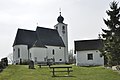
Parish church of Obergrünburg

Leonstein parish church

Leonstein ruins

Leonstein Castle. On the right in the foreground the Steyrtalradweg, on the left the Steyrtal Straße
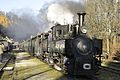
Steam locomotive in the museum station Grünburg (Waldneukirchen)

The new mansion in the Schmiedleithen open-air museum

Grünburg reception building

Rinnerberg waterfall


.jpg)


Regular events
- Local festival in Grünburg
- Western ball on Pentecost Sunday
- Workers' ball in Leonstein
- Advent in Leonstein Castle
- Wine festival in the Bergmaier Russmann nursery
- Peter fire in Leonstein
- Midsummer bonfire of the nature lovers Leonstein
- Cross-country run in Leonstein
- Leonsteiner Kirtag: takes place on the 12th Sunday after Pentecost
- Badfest
- Wine festival
- Jazz4Hammer
- Hammerschmiedfest (1st holiday weekend)
- Torchlight hike to the Schmiedleithen (6 January)
- Carnival parades on Mardi Gras Saturday (alternately in Leonstein and Grünburg)
societies
- Youth fire brigade Grünburg
- Youth fire brigade Leonstein
- Fire brigade youth car lift
- Cultural Association d'Hammerschmied
- Men's choir Grünburg-Steinbach
- Leonstein Music Association
- Boy Scout Leonstein
- Atib Leonstein
- Integration Association Leonstein-Molln
- Atib Grünburg
- Goldhaubengruppe Grünburg
- Goldhaubengruppe Leonstein
- Country youth Steinbach / Grünburg
- Trachtenmusikkapelle Grünburg
Personalities
Sons and daughters of the church
- Grünburger (Grunenpurch), a noble family of the 12th and 13th centuries
- Franz Hueber (1894–1981), notary and politician
- Johann Nepomuk von Alpenburg (1806–1873), Austrian poet and author, patron
- Georg Rabuse (1910–1976), Austrian Romance studies and literary scholar, (born in Leonstein)
- Leopold Gressenbauer (1931–1988), Austrian politician (SPÖ)
- Eduard Bousrd Bangerl (1956–2012), educator and painter
- Gerhard Fallent (* 1960), Austrian politician (ÖVP-> FPÖ)
People related to the community
- Georg Matthäus Vischer (1628–1696), cartographer, topographer, clergyman, one of the most important cartographers in Austria
- Matthäus Gaspelmayer (1872–1945), farmer and politician
Web links
- Homepage of the community of Grünburg
- Further information about the municipality of Grünburg can be found on the geographic information system of the federal state of Upper Austria .
Individual evidence
- ↑ Statistics Austria: Population on January 1st, 2020 by locality (area status on January 1st, 2020) , ( CSV )
- ↑ a b Georg Matthäus Vischer: Archiducatus Austriae Superioris Descriptio facta Anno 1667 . Supplement to the reprint of Topographia Austriae superioris modernae . Vienna: Archiv Verlag 2005.
- ↑ The Lords of Grünburg at nikolauskapelle.at (accessed November 8, 2019).
- ↑ a b So still in the Josephinische Landesaufnahme around 1780; the Franciscan cadastre around 1830 already gives Ob. Grünburg (layer online at DORIS).
- ↑ Steyrtal Cycle Path North (PDF; 444 kB)

Edlbach | Grünburg | Hinterstoder | Inzersdorf im Kremstal | Kirchdorf an der Krems | Klaus at the Pyhrnbahn | Kremsmünster | Micheldorf in Upper Austria | Molln | Nussbach | Oberschlierbach | Pettenbach | Ried im Traunkreis | Rosenau am Hengstpaß | Roßleithen | St. Pankraz | Schlierbach | Spital am Pyhrn | Steinbach am Ziehberg | Steinbach an der Steyr | Vorderstoder | Wartberg an der Krems | Windischgarsten
Cadastral communities and localities: Leonstein | Obergrünburg | Pernzell | Untergrünburg | Carriage lift
Villages: Leonstein • Obergrünburg • Pernzell • Untergrünburg | Hamlet: Agonitz • Priethal | Rotten: Au • Außerort • Furth • Haunoldmühle • Priethal • Rohregg • Schmiedleithen • Schnitzlhub • Steyr Leithen • Wurzer farmers | Settlement: Oberleonstein | Scattered houses: Hambaum • Pernzell • plan trench Steyr breakthrough • Wagenhub | Other locations: Windhag
Counting district: Untergrünburg - Wagenhub | Obergrünburg - Pernzell | Leonstein
Unusual locations: Rinnerberg