
Rosenau am Hengstpaß
|
Rosenau am Hengstpaß
|
||
|---|---|---|
| coat of arms | Austria map | |
 |
|
|
| Basic data | ||
| Country: | Austria | |
| State : | Upper Austria | |
| Political District : | Church Village | |
| License plate : | AI | |
| Surface: | 107.86 km² | |
| Coordinates : | 47 ° 43 ' N , 14 ° 24' E | |
| Height : | 700 m above sea level A. | |
| Residents : | 650 (January 1, 2020) | |
| Population density : | 6 inhabitants per km² | |
| Postal code : | 4581 | |
| Area code : | 07566 | |
| Community code : | 4 09 14 | |
| NUTS region | AT314 | |
| Address of the municipal administration: |
Hauptstrasse 16 4581 Rosenau am Hengstpaß |
|
| Website: | ||
| politics | ||
| Mayoress : | Maria Benedetter ( SPÖ ) | |
|
Municipal Council : (2015) (13 members) |
||
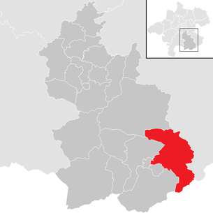
| Location of Rosenau am Hengstpaß in the Kirchdorf district | ||
  |
||
| Source: Municipal data from Statistics Austria | ||

Rosenau am Hengstpaß is a municipality in Upper Austria in the Kirchdorf an der Krems district in the Traunviertel with 650 inhabitants (as of January 1, 2020).
geography
Rosenau am Hengstpaß is located at an altitude of 690 m in the Traunviertel. The extension is 13 km from north to south and 16.6 km from west to east. The total area is 108.2 km². 70.4% of the area is forested and 12.8% of the area is used for agriculture .
Community structure
Until 2020, the municipality included the villages of Dambach and Rosenau am Hengstpaß. Since 2020 the municipality has only consisted of one village.
The community consists of the cadastral community Rosenau.
coat of arms
Official description of the municipal coat of arms : In silver under a blue, raised corrugated strip, on it three green conifers adjoining the upper edge of the shield, a red, heraldic alpine rose with golden lugs and green sepals, enclosed by a black water wheel. The community colors are green-white-red.
The heraldic stylized alpine rose speaks both in the common sense for the place name and as a mountain flower (Rhododendron hirsutum) for the location of the municipality in the northern Limestone Alps.
The blue waves mark the Dambach , which rises in the municipality, the three conifers explain the wealth of forests in the area.
The water wheel is reminiscent of the former scythe factory in Dambach.
history
Originally located in the eastern part of the Duchy of Bavaria , the place belonged to the Duchy of Austria since the 12th century. Since 1490 it has been assigned to the Principality of Austria ob der Enns . During the Napoleonic Wars , the place was occupied several times.
Since 1918 the place belongs to the federal state of Upper Austria. After the annexation of Austria to the German Reich on March 13, 1938, the place belonged to the Gau Oberdonau . After 1945 the restoration of Upper Austria took place.
Rosenau belonged to the Windischgarsten judicial district until 2012 and has been part of the Kirchdorf an der Krems judicial district since January 1, 2013 .
Culture and sights

- Branch church Rosenau : built 1949–1950 according to plans by Hans Foschum
Personalities
Sons and daughters of the church
- Raimund Baumschlager (* 1959), rally driver
Town twinning
A partnership with the German city of Hofgeismar in northern Hesse has existed since 1983 .
Population development
In 1991 the community had 790 inhabitants according to the census; 2001 then 744 inhabitants. By 2018 the population had decreased to 663. The reason for this is the negative balance of migration , which can not be offset by a slightly positive birth balance.
Individual evidence
- ^ Province of Upper Austria, coat of arms of the municipality of Rosenau. Retrieved March 22, 2019 .
- ↑ Statistics Austria, A look at the community of Rosenau am Hengstpaß, population development. Retrieved March 22, 2019 .
Web links
- Further information about the municipality of Rosenau am Hengstpaß on the geo-information system of the federal state of Upper Austria .
- Official site for Rosenau am Hengstpaß of the tourism association

Edlbach | Grünburg | Hinterstoder | Inzersdorf im Kremstal | Kirchdorf an der Krems | Klaus at the Pyhrnbahn | Kremsmünster | Micheldorf in Upper Austria | Molln | Nussbach | Oberschlierbach | Pettenbach | Ried im Traunkreis | Rosenau am Hengstpaß | Roßleithen | St. Pankraz | Schlierbach | Spital am Pyhrn | Steinbach am Ziehberg | Steinbach an der Steyr | Vorderstoder | Wartberg an der Krems | Windischgarsten