St. Pankraz (Upper Austria)
|
St. Pankraz
|
||
|---|---|---|
| coat of arms | Austria map | |
|
|
||
| Basic data | ||
| Country: | Austria | |
| State : | Upper Austria | |
| Political District : | Church Village | |
| License plate : | AI | |
| Surface: | 47.15 km² | |
| Coordinates : | 47 ° 46 ' N , 14 ° 13' E | |
| Height : | 531 m above sea level A. | |
| Residents : | 359 (January 1, 2020) | |
| Postal code : | 4572 | |
| Area code : | 07565 | |
| Community code : | 4 09 16 | |
| NUTS region | AT314 | |
| Address of the municipal administration: |
St. Pankraz 1 4572 St. Pankraz |
|
| Website: | ||
| politics | ||
| Mayor : | Manfred Degelsegger ( SPÖ ) | |
|
Municipal Council : (2015) (9 members) |
||
| Location of St. Pankraz in the Kirchdorf district | ||
 Mesnerhaus, parish church and rectory |
||
| Source: Municipal data from Statistics Austria | ||
St. Pankraz (also Sankt Pankraz ) is a municipality in Upper Austria in the Kirchdorf an der Krems district in the Traunviertel with 359 inhabitants (as of January 1, 2020).
geography
St. Pankraz is located at an altitude of 531 m in the Traunviertel. The extension is 9.7 km from north to south and 8.7 km from west to east. The total area is 47.15 km². 70.3% of the area is forested and 8.5% of the area is used for agriculture. St. Pankraz is part of the Pyhrn-Priel tourist region .
Community structure
The municipality includes the following two localities (population in brackets as of January 1, 2020):
- Saint Pankraz (292)
- Schalchgraben (67)
The community consists of the only cadastral parish of St. Pankraz.
Neighboring communities
| Minor | ||
| Klaus at the Pyhrnbahn |

|
|
| Hinterstoder | Vorderstoder | Rossleithen |
coat of arms
Blazon :
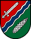
- "Divided by red and green by a blue, silver-bordered, oblique left wave bar, accompanied by a silver sword according to the figure above and a silver pine cone below."
The municipality colors are blue-white-red.
The sloping river points to the Teichl crossing the municipality from southeast to northwest . St. Pankratius , church patron and place-name giver, is represented with his attribute , the sword, in the upper half of the coat of arms. The pine cone covered with woody fruit scales underlines the abundance of forests in the community with 86% forestry use of the productive area.
history
Originally located in the eastern part of the Duchy of Bavaria , the place belonged to the Duchy of Austria since the 12th century . Since 1490 it has been assigned to the Principality of Austria ob der Enns .
During the Napoleonic Wars , the place was occupied several times.
Since 1918 the place belongs to the federal state of Upper Austria. After the annexation of Austria to the German Reich on March 13, 1938, the place belonged to the Gau Oberdonau . In 1945 Upper Austria was restored.
St. Pankraz belonged to the Windischgarsten judicial district until 2012 and has been part of the Kirchdorf an der Krems judicial district since January 1, 2013 .
Population development
In 1991 the community had 372 inhabitants according to the census, in 2001 it had 390 inhabitants.
Culture and sights
- Parish Church of St. Pankraz
- Poaching Museum St. Pankraz: The exhibition, based on the ideas of the cultural scientist Roland Girtler , shows the historical and social background of poaching. Well-known fates of poachers and the legendary poaching battle of Molln are also documented.
National Park Kalkalpenradweg
The National Park Kalkalpenradweg (R31) has its starting point in the center of St. Pankraz. The cycle path leads through the valley of the Teichl up to Roßleithen and on to Windischgarsten. After a ride over the Hengstpass , the cycle path ends after 45 km at the confluence with the Hintergebirgsradweg near Unterlaussa .
Sons and daughters of the place
- Hannes Trinkl (* 1968), ski racer
Individual evidence
- ↑ The official spelling is specified or shown in the list of the municipalities of the Upper Austrian provincial government on the Internet and on Statistics Austria: A look at the municipality
- ↑ Statistics Austria: Population on January 1st, 2020 by locality (area status on January 1st, 2020) , ( CSV )
Web links
- Further information about the municipality of St. Pankraz (Upper Austria) can be found on the geographic information system of the federal state of Upper Austria .


