
Ried in the Traunkreis
|
Ried in the Traunkreis
|
||
|---|---|---|
| coat of arms | Austria map | |
 |
|
|
| Basic data | ||
| Country: | Austria | |
| State : | Upper Austria | |
| Political District : | Church Village | |
| License plate : | AI | |
| Surface: | 31.16 km² | |
| Coordinates : | 48 ° 2 ' N , 14 ° 4' E | |
| Height : | 469 m above sea level A. | |
| Residents : | 2,785 (January 1, 2020) | |
| Population density : | 89 inhabitants per km² | |
| Postal code : | 4551 | |
| Area code : | 07588 | |
| Community code : | 4 09 13 | |
| NUTS region | AT314 | |
| Address of the municipal administration: |
Hauptstrasse 27 4551 Ried im Traunkreis |
|
| Website: | ||
| politics | ||
| Mayor : | Helmut Hechwarter ( ÖVP ) | |
|
Municipal Council : (2015) (25 members) |
||
| Location of Ried im Traunkreis in the Kirchdorf district | ||
  |
||

|
||
| Source: Municipal data from Statistics Austria | ||

Ried im Traunkreis is a municipality in Upper Austria in the Kirchdorf an der Krems district in the Traunviertel with 2785 inhabitants (as of January 1, 2020). The responsible judicial district is Kirchdorf an der Krems .
geography
The community is located at an altitude of 469 m in the Traunviertel . The extension is 7.2 km from north to south and 7.7 km from west to east. The total area is 31 km². 9% of the area is forested and 81.3% of the area is used for agriculture.
Neighboring communities
Ried is bounded in the north by the municipality of Sattledt and in the northwest by Eberstalzell . These communities already belong to the political district of Wels-Land . Thus, Ried forms a border between the districts of Kirchdorf and Wels-Land. In the east, Ried borders on Kremsmünster , in the south on Wartberg . The south-western neighbor is the municipality of Pettenbach .
| Sattledt | Kremsmünster | |
| Eberstalzell |
.svg)
|
|
| Pettenbach | Wartberg |
Community structure
The municipality includes the following 11 localities (population in brackets as of January 1, 2020):
- Grossendorf (360)
- Hammersdorf (0)
- Maidorf (6)
- Penzendorf (62)
- Pesendorf (159)
- Ried im Traunkreis (1401)
- Rührndorf (170)
- Chess Village (60)
- Voitsdorf (358)
- Weigersdorf (99)
- Zenndorf (110)
The community consists of the cadastral communities Ried im Traunkreis, Rührndorf, Voitsdorf and Zenndorf.
Population development
| year | Population according to the census |
|---|---|
| 1870 |
|
| 1900 |
|
| 1920 |
|
| 1934 |
|
| 1961 |
|
| 1971 |
|
| 1981 |
|
| 1991 |
|
| 2001 |
|
| 2011 |
|
| 2018 |
|
The population growth of the last three decades can be traced back to a very positive migration balance, the birth balance is close to zero.
coat of arms
Blazon : Divided between two black wave flanks of gold and green; at the top a red miter with a golden pole pointed at the top, embroidered with three red, floating crosses, covered with two red ribbons curving upwards; below a golden, left-turning, leaping deer. The community colors are yellow-green-yellow.
Creation of the municipal coat of arms
After the municipality's long wish to have its own coat of arms and the approval of the Upper Austrian state parliament, the municipal council had to find a symbol to represent the coat of arms. 3 drafts were made, such as B. a bishop's cap, an ear of corn, a deer and a flame. Ultimately, the Gothic shield shape with a miter and a jumping deer was adopted from the drafts at hand . The miter refers to the church patron , Saint Nicholas . The stag represents the coat of arms of the Meurl family from Rechberg. The two flanks of the waves symbolize the production of crude oil in the municipality.
politics
- Mayor Helmut Hechwarter ( ÖVP )
- Vice Mayor Fritz Steinmaurer (ÖVP)
Parish council
- Maria Fischer ( ÖVP )
- Irene Krumphuber (ÖVP)
- Adolf Stepan (ÖVP)
- Gerhard Ameshofer ( SPÖ )
- Friedrich Langeder ( FPÖ )
The municipal council consists of 25 members (13 ÖVP, 7 FPÖ, 5 SPÖ)
history
Early settlement
Younger Stone Age
As early as the Neolithic Age, there was a small settlement near the village of Neudorf. Many stone axes made of serpentine, knocking and rubbing stones and also many ceramic fragments were found there.
La Tène period
Approx. 600 years BC Celts moved from what is now France across the Rhine to the Danube. Celtic names such as Alm, Traun, but also a find of a Celtic gold coin ( roll animal stater ) in Kematen an der Krems suggest that the area of Ried was also inhabited during the Celtic times.
Roman times

As early as Roman times , Ried was on the main connection from Wels to the Pyhrn Pass . It was a Via Militaris . The most likely route led from Wels (Ovilava) via Steinhaus along the Aiterbach to Pettenbach . A Roman stone set in the outside of the cemetery wall, which shows a medallion with the head of a local woman with a modiushaque, flanked by reclining lions, as well as a coin of the emperor Probus (282 AD), which was found in a field in Ried im Traunkreis in 1850 testify to that time. The most important Roman find is the remains of a Mithraic temple in a former gravel pit.
middle Ages
Bavarians and Slavs
In the middle of the 6th century the Bavarians invaded the area. At the beginning of the 7th century Slavic settlers came from the south. The Bavarians primarily settled in the foothills of the Alps, whereas the Slavs settled in the mountain valleys. Both tribes settled in the area around Ried .
777 founded Duke Tassilo III. the Kremsmünster Abbey and the monastery made the area arable. The proximity of the monastery brought early cultivation, which was carried out by Slavs, but also by Bavarian colonists.
The first documentary mention
Ried was first mentioned in a document in 993 in a contract between Count Arnold von Wels-Lambach and Bishop Christian von Passau , which involved the return of lands that Wels-Lambach had acquired from Kremsmünster Abbey after the Hungarian invasions . In the original it said:
"Conoucatis itaque in eadem predia non paucis amborum amicis idem iam dictus Arnoldus comes, quod sibi inscienter ursurpauit, prosus in posterum abdiuit duobus in Stainfeld receptis mansis et loco Rivt a quodam illius monasterri servo Mazilino nomine suulto et nlauseo."
Roughly translated
“... the already mentioned Count Arnold completely renounced for the future what he had unknowingly usurped after he had received 2 manes in the stone field, both on the town of Rivt, which had been cleared by a servant of the Mazilinus monastery, and to a new break in the possession of his slave Wenco. "
Origin of the place name
The name Ried is derived from the older spellings Rivt, Riut, Reuth and means "cleared area".
clearing , nd., reuten or "clearing" (removing the trees together with the roots): -rod (e) -, -roden- (Rodenkirchen), with -ing on the Harz to -ingerode / -igerode (Wernigerode), - rohd / t, rothe (but these also belong to Rotte "Weiler"); Roid, -roith; Rott; Röd / t / dt; -rad (e) -, -raht, -rath; -raut (he); -ray; Reit, Reith, -greith, -rheid; -reut (h) - (Reutlingen, Bayreuth), Reute, Reutte; Ried, -rieth (but also to Ried "Röhricht"); ruid / t; rüti, rhüti (in Switzerland)
Modern times
Peasant revolts
In 1596, Rieder also took part in the Second Upper Austrian Peasant Revolt (1595–1597). On November 16, 1596, a meeting was held in the Strienzing tavern. It became a "public disrepute" that every peasant and resident who could carry a man and a sword had to appear with his house guard on November 18, 1596 at the parish church. The peasants were forced to riot under threat of "chopping off their heads and burning their houses". On November 19, 1596, under the leadership of the farmer's captain Georg Tasch, a runaway innkeeper from Pettenbach, they moved against Schlierbach Abbey. Georg Tasch and other leaders were captured after the siege of Steyr in 1599 and executed in September 1599.
In the peasant uprising of 1626 ( Upper Austrian Peasants' War ) hardly any Rieder took part, because the population had to endure a lot from the rebels.
pest
The plague claimed many victims, it is said that many died of the plague in Ried too. High mortality rates were recorded in 1677 (65), 1684 (108), 1685 (60), 1694 (97). In the year 1713 290 people died, including 270 from the plague.
French invasions
During the Napoleonic Wars - coalition wars , the place was occupied several times in 1801, 1805 and 1809. There were also attacks on the population and numerous looting.
Ried becomes an independent municipality
In 1848, apart from the free markets such as B. Wels no political communities. However, so-called tax communities existed (since the introduction of the cadastre under Maria Theresa in 1752). At that time there were four tax communities in Ried: Ried, Voitsdorf, Zenndorf and Rührndorf. The lordship was abolished, the political districts and municipalities were formed, and in 1850 a mayor was elected for the first time.
End of the manorial system
Hans Kudlich (1823–1917), member of the Reichstag , made an application for the annulment of the subject relationship in 1848, which received unanimous approval and was implemented on September 7, 1848 with an imperial patent . He was supported by 13 Upper Austrian farmers who took part in the so-called “farmers liberation”, including Michael Klausner, the first mayor of Ried.
It is thanks to you and Hans Kudlich that a free peasant class could develop in Austria.
Manorials in Ried in 1848
| Manorial rule | number |
|---|---|
| Kremsmünster Abbey | 125 |
| Wels Castle | 96 |
| Pernstein | 21st |
| Stone house | 20th |
| Scharnstein | 8th |
| Schlierbach | 6th |
| Leonstein | 6th |
| Lauterbach | 5 |
| Seisenburg | 5 |
| Hartheim | 4th |
| Achleiten | 3 |
| Spital at Steyr | 3 |
| Bad Hall | 3 |
| Almegg | 2 |
| Bruckamt Wels | 2 |
| Ried rectory | 2 |
| Eggendorf | 1 |
| Feyregg | 1 |
| Cooked | 1 |
| Lichtenegg rectory | 1 |
| Lambach Abbey | 1 |
| Total number | 316 |
Since the 20th century
First World War
Like everywhere else, at the beginning of the First World War there was initially great euphoria and the opinion that Serbia would be quickly defeated. Despite the lack of labor and draft animals, a relatively good summer harvest in 1914 was brought in due to the weather. In 1916 a rise in the price of flour caused general public spirits. On January 4, 1917, the two largest bells were lowered and later melted down. At the beginning of 1918, the 18-year-olds still had to take a position. While in March 1918 the first soldiers returned from captivity after the peace agreement with Russia and Romania, the boys still had to enter.
Interwar period
After the end of the First World War, the need was omnipresent. There was a lack of commodities of all kinds. The collapse of money reached its peak in the autumn of 1922. On April 1, 1925, the shilling currency was introduced. Nevertheless, the economic situation continued to deteriorate, and the global economic crisis was noticeable for the population. A total of 65 men did not return home. A memorial was erected in the entrance hall of the parish churches to the fallen and missing of the First World War.
The time of National Socialism
After the German Wehrmacht marched into Austria on March 13, 1938, the parish councils were dissolved on March 13, 1938 and from then on the parish belonged to the "Gau Oberdonau". On March 15, 1938, the first meeting of the new NS municipal council took place. In the referendum on the annexation of Austria to the German Reich , an approval of almost 100% was achieved under pressure and impression of the circumstances at the time. In August 1939, food cards and vouchers were introduced.
Second World War
On February 23, 1944, eight American airmen were captured after aerial battles and transferred to Wels. During this fighting, a German fighter plane crashed on a meadow in Prachersdorf. On November 5, 1944, 176 refugees from the Banat arrived and were housed in the school. On May 5, 1945, American units occupied the community of Ried without a fight. The Americans stayed in town for 14 days. The municipal council, which functioned before the war, and mayor Pimmingsdorfer were reinstated. A total of 140 fallen and missing persons are to be lamented, their names are recorded on the war memorial at the upper cemetery entrance.
Parish since 1946
Over the past few decades, Ried has developed from a primarily agricultural society to a place with lively commercial and industrial activity. Despite all this, the agricultural sector is still well represented.
Culture and sights
- Parish church in Ried im Traunkreis
- Filialkirche Weigersdorf: Around 903 there was a simple wooden chapel at its current location. In 1162, Bishop Konrad von Passau consecrated the church in honor of Saint James the Elder . Approx. In 1437, under Abbot Ulrich, the construction of the presbytery in its present form should have started. In the same year the chapel in Weigersdorf (St. Jakob) was incorporated. However, it is documented that it was completed in 1476. It was solemnly consecrated on August 21, 1476 by Auxiliary Bishop Albert von Passau . Like the mother church, Weigersdorf belongs to the late Gothic period . Both are two-aisled hall churches with a completely symmetrical layout. Today the church has three altars and a pulpit, which date from the Baroque period.

Catholic parish church hl. Nicholas

Choir of the parish church
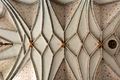
Ribbed vault in the choir

Weigersdorf Church

Altar of the church in Weigersdorf

Gallery of the church in Weigersdorf


- Rechberg Castle: In the village of Rührndorf there was a castle called Rechberg on a hill on the left bank of the Aiterbach , as evidenced by the names still existing as Hofmühle, Schloßleiten, Schenk- und Baderhaus, Ober- and Niedermeaier and evidence of moats. It is not known whether it was the ancestral seat of the Lords of Rechberg, of whom we find Dimo 1170, Konrad 1176, Heinrich 1189 to 1206, the Herman and Ottokar brothers and the Wluinch and Friedrich von Rechpoerch brothers from 1245 to 1247, but it is probable. After the Rechbergers died out, Rechberg came to the Losensteiners, who donated a chaplain in the church to Losenstein when the nearby Gatterhof was donated to the Garsten monastery. As a result, Rechberg was owned by the Polheimers . The brothers "Wickhard and Pilgram, the Polheimers von Rechberg", who also owned the Steinhaus lordship on the lower reaches of the Aiterbach , sold their uncle Georg von Volkersdorf a property on the "Oede" and "one" in the Rollepache near Weißenberg in the Puckinger in 1357 Parish. A short time later (1363) Rechberg was owned by the Meurl. It is not known when the castle became deserted.
- Legend of Rechberg Castle: The legend tells that two brothers from the family got into such bitter arguments over their property that they persecuted each other to their death. When they met in the parish church of Ried, one stabbed the other behind the high altar. Because of this atrocity, the service in the desecrated church was suspended for a long time and the parishioners in the church in Weigersdorf were granted permission. However, since a large part of the parish residents were too far away from this, they were incorporated into the Wartberg parish, from which only, and only in 1785, the village of Voitsdorf came back to Ried.
traffic
The A9 Pyhrnautobahn and the B138 Pyhrnpaßbundesstraße run through the municipality in a north-south direction, and in an east-west direction the L562 Kremsmünsterer Landstraße. In addition, there are district, community, access roads and local roads. Most of the road network is dust-free (asphalted). The road network has a total length of around 120 km.
Personalities
Honorary citizen
- P. Edmund Forsthuber, pastor in Ried from 1871 to 1879, with a municipal council resolution of March 17, 1879
- Adolf Hager, doctor in Ried from 1849 to 1900, with a municipal council resolution of March 19, 1889
- Father Richard Kohlendorfer, pastor in Ried from 1885 to 1907, with a municipal council resolution of July 28, 1895
- Adolf Neuber, head of the district administration in Steyr, with a municipal council resolution of August 4, 1918
- Hans Steinmaurer, community doctor in Ried from 1908 to 1936, with a local council resolution of September 17, 1922
- David Wieser, senior teacher at the elementary school from 1898 to 1924, with a municipal council resolution of July 20, 1924
- Father Michael Gerstmair, pastor of Ried, with a resolution of the local council of April 15, 1928
- P. Karl Hochuber, cooperator in Ried, with a municipal council resolution of April 15, 1928
- Mathias Zaunmair, Mayor of Ried, with a municipal council resolution of October 29, 1933
- P. Hermann Hahn, in Schlierbach, with a municipal council resolution of October 29, 1933
- Johann Pimmingsdorfer, Mayor of Ried, with a municipal council resolution of August 16, 1937
- General Mark W. Clark , American general, by local council resolution dated July 31, 1946
- Josef Minichmair, Vice Mayor of Ried, with a municipal council resolution of August 17, 1952
- Johann Achleitner, community committee member in Großendorf, with a local council resolution of August 17, 1952
- Josef Achleitner, member of the community committee in Weigersdorf, with a resolution of the local council dated August 17, 1952
- Franz Atzlinger, member of the community committee in Pesendorf, with a local council resolution of August 17, 1952
- Hans Winkler, local doctor in Ried, with a local council resolution of 23 August 1953
- Josef Maxwald, master blacksmith in Ried, with a municipal council resolution of 23 August 1953
- Father Wolfgang Stadlbauer, pastor of Ried, with a resolution of the municipal council of July 11, 1964
- Franz Schimpl, municipal secretary in Ried, with a municipal council resolution of March 7, 1969
- Franz Huebmer, schoolmaster in Ried, with a municipal council resolution of March 7, 1969
- Hans-Peter Hartmann, community doctor in Ried, was awarded the community's ring of honor for special merits
Sons and daughters of the church
- Franz Reichleitner (1906–1944), criminal investigator and SS leader
- Gottfried Nobl (1923–2017), architect and master builder of the cathedral
Web links
- Ried im Traunkreis community
- 40913 - Ried im Traunkreis. Community data, Statistics Austria .
- Further information about the municipality of Ried im Traunkreis can be found on the geographic information system of the federal state of Upper Austria .
Individual evidence
- ↑ Statistics Austria: Population on January 1st, 2020 by locality (area status on January 1st, 2020) , ( CSV )
- ^ Statistics Austria, A look at the community of Ried im Traunkreis, population development. Retrieved March 23, 2019 .
- ^ Province of Upper Austria, coat of arms of the municipality of Ried im Traunkreis. Retrieved March 23, 2019 .
- ↑ Website of Helmut Hechwarter
- ^ Johann Lichtenwöhrer: Neolithic site in Ried / Trk. at Kremsmünster. In: Reports of the Anselm Desing Association. No. 43, June 2007, pp. 3-7.
- ^ Heidelinde Dimt: Fund coins from the Georgenberg near Micheldorf / Upper Austria. In: Yearbook of the Upper Austrian Museum Association. Volume 124a, Linz 1979, pp. 27-32 ( PDF on ZOBODAT ).
- ↑ Herrstraße Via Militaris
- ↑ http://www.ubi-erat-lupa.org/monument.php?id=596
- ↑ http://www.ubi-erat-lupa.org/monument.php?id=12006

Edlbach | Grünburg | Hinterstoder | Inzersdorf im Kremstal | Kirchdorf an der Krems | Klaus at the Pyhrnbahn | Kremsmünster | Micheldorf in Upper Austria | Molln | Nussbach | Oberschlierbach | Pettenbach | Ried im Traunkreis | Rosenau am Hengstpaß | Roßleithen | St. Pankraz | Schlierbach | Spital am Pyhrn | Steinbach am Ziehberg | Steinbach an der Steyr | Vorderstoder | Wartberg an der Krems | Windischgarsten