
Pettenbach (Upper Austria)
|
market community Pettenbach
|
||
|---|---|---|
| coat of arms | Austria map | |
 |
|
|
| Basic data | ||
| Country: | Austria | |
| State : | Upper Austria | |
| Political District : | Church Village | |
| License plate : | AI | |
| Surface: | 54.7 km² | |
| Coordinates : | 47 ° 58 ' N , 14 ° 1' E | |
| Height : | 486 m above sea level A. | |
| Residents : | 5,321 (January 1, 2020) | |
| Population density : | 97 inhabitants per km² | |
| Postal code : | 4643 | |
| Area code : | 07586 | |
| Community code : | 4 09 12 | |
| NUTS region | AT314 | |
| Address of the municipal administration: |
Kirchenplatz 3 4643 Pettenbach |
|
| Website: | ||
| politics | ||
| Mayor : | Leopold Bimminger ( ÖVP ) | |
|
Municipal Council : (2015) (31 members) |
||
| Location of Pettenbach in the Kirchdorf district | ||
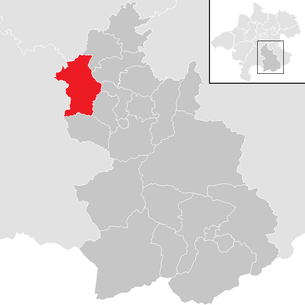  |
||
 Parish church hl. Benedict and market town hall in the center |
||
| Source: Municipal data from Statistics Austria | ||

Pettenbach is a market town in Upper Austria in the Kirchdorf an der Krems district in the Traunviertel with 5111 inhabitants (as of January 1, 2020). The responsible judicial district is Kirchdorf an der Krems .
geography
The main town of Pettenbach is 486 m above sea level. A. Höhe in the Traunviertel . The municipality stretches from Pernecker Kogel ( 1080 m above sea level ) in the south to Ried im Traunkreis in the north. The extension is 8.8 km from north to south and 11.3 km from west to east. The total area is 54.8 km². 15.7% of the area is forested and 73.7% of the area is used for agriculture.
Community structure
The municipal area comprises the following 10 localities (population in brackets as of January 1, 2020):
- Dürndorf (852)
- Etzelsdorf (326)
- Gundendorf (189)
- Hammersdorf (306)
- Lungendorf (355)
- Magdalenaberg (211)
- Mitterndorf (849)
- Pettenbach (1539)
- Pratsdorf (566)
- Steinfelden (128)
The community consists of the cadastral communities Gundendorf, Hammersdorf, Lungendorf, Mitterndorf, Pettenbach, Pratsdorf, Seisenburg and Unterdürndorf.
Neighboring communities
Neighboring communities are: Eberstalzell , Inzersdorf im Kremstal , Ried im Traunkreis , Scharnstein , Schlierbach , Steinbach am Ziehberg , Vorchdorf and Wartberg an der Krems .
| Vorchdorf | Eberstalzell | reed |
.svg)
|
Wartberg, Schlierbach | |
| Scharnstein | Steinbach | Inzersdorf |

Pettenbach borders the Gmunden and Wels-Land districts .
Population development
In 1991 the community had 4,297 inhabitants according to the census, in 2001 then 4,747 inhabitants. In 2016 the market town of Pettenbach already had 5,182 inhabitants and grew to 5,272 people by 2018. The reason is the very positive birth balance .
coat of arms
Official description of the municipal coat of arms awarded in 1977: Under the red head of the shield, in it a silver oblique left-hand bar, split from the right to the left half of the shield; on the left, in green, a golden chalice with a golden snake , turned to the right, crawling in an arch through the cupah , upright in front and behind; on the right a green, fallen morning star in gold. The community colors are green-yellow.
The chalice with the snake indicates on the one hand St. Benedict as the patron saint of the church and, on the other hand, symbolically underlines the affiliation of the early mission parish to the Benedictine monastery Kremsmünster.
The mace, known as the “Morgenstern”, is supposed to be a typical peasant war weapon in memory of the Pettenbach landlord Georg Tasch, who, with Hans Salig from Kematen, was the main leader in the uprising of the Traunviertel farmers in 1596.
The red-white-red shield head emphasizes the community's ties with the state of Austria.
history
Originally located in the eastern part of the Duchy of Bavaria, the place belonged to the Duchy of Austria since the 12th century. Since 1490 it has been assigned to the Principality of Austria ob der Enns .
During the Napoleonic Wars , the place was occupied several times.
Since 1918 the place belongs to the federal state of Upper Austria. After the annexation of Austria to the German Reich on March 13, 1938, the place belonged to the Gau Oberdonau . After 1945 the restoration of Upper Austria took place.
politics
- mayor
- until 2012 Friedrich Schuster (ÖVP)
- since 2012 Leopold Bimminger (ÖVP)
Culture and sights
- The Bartlhaus Font and Local History Museum contains the life's work of the font artist Leopold Feichtinger, who lived and worked in Pettenbach, and Friedrich Neugebauer . A wide variety of ex-libris, saying cards and sheets, certificates, coats of arms and much more are on display. Every year there are also additional special exhibitions and written courses are offered. The museum also houses the Pettenbach local history museum with a special exhibition about the Seisenburg ruins. In 2006 the museum was expanded to include a printing museum. The outstanding personality of the association is Ottmar Premstaller , who lives in St. Georgen an der Gusen and to whom the 2010 annual exhibition of the museum was dedicated.
- The parish church of Pettenbach was built in 1484 as a late Gothic, three-aisled hall church. The baroque altar fittings are particularly worth seeing.
- The Magdalenaberg parish and pilgrimage church was built around 1500 as a late Gothic, two-aisled hall church. After a fire, the church was given a Renaissance vault around 1629. The furnishings are in the baroque style. The baroque altarpiece of St. Mary Magdalene is remarkable here. Every year numerous pilgrimages take place on the Magdalenaberg. In cooperation with the cultural department of the market town of Pettenbach, invitations to the “musical pilgrimage” take place several times a year.
- The Heiligenleithen branch and pilgrimage church: This was built in 1431 in the late Gothic style as a single-nave hall church and is equipped with baroque side altars and a neo-Gothic high altar. A special gem is a statue of St. Leonhard from the 15th century. The church is known far beyond the borders of Pettenbach for the Leonhardiritt, which takes place every year on November 6th.
- Peace Cross Oberkaibling: In October 1967 the 20 meter high illuminated metal cross was erected on the initiative of the Comradeship Association of the Kirchdorf ad Krems district as thanks for the return of many soldiers from the Second World War . When illuminated, it is visible far into the Upper Austrian central area and represents a symbol of peace.
- Seisenburg : In the 12th century a fortress Seisenburg was mentioned for the first time and in 1609 it was converted into a Renaissance castle. After the First World War , the castle deteriorated more and more until only a ruin remained. At the moment, hard-working helpers from Pettenbach are repairing the remains of the ruins and clearing the rubble from the walls and securing them. An exhibition in the Bartlhaus Museum offers a fascinating impression of the former splendid Renaissance building. Three well-preserved so-called death shields from the Seisenburg from the time of the reign of the Counts Engel are in the market town hall.

Parish church hl. Benedict
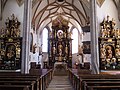
Choir of the parish church of St. Benedict

The parish church on Magdalenaberg

Ruins of Seisenburg Castle


Clubs and organizations
- Camerata Vocalis (choral society - four-part choir since 1995)
- Union Sparkasse Pettenbach football club
- Music Association Pettenbach
- Volunteer Fire Brigade Eggenstein
- Volunteer Fire Brigade Gundendorf
- Volunteer Fire Brigade Magdalenaberg
- Volunteer Fire Brigade Pettenbach
- Volunteer fire brigade Pratsdorf-Hammersdorf
- Freiw. Fire brigade Steinfelden
- Carnival Association Sauzipfler
- Table tennis club Pettenbach
- Sportunion Pettenbach - Riding Section
- Theater Association Kunstbrettl AGe
- UTC Pettenbach (tennis)
- SU-Tritec Pettenbach (Ski Section of Union Pettenbach)
- ESVU Pettenbach (section curling of the Union Pettenbach)
- Fire and Roboth Aid Association Pettenbach
- Fetznplattler (Schuhplattler)
traffic
Pettenbach is located on the Almtalbahn , a non-electrified branch line from Wels to Grünau im Almtal . The Pettenbach train station and the Wilfling, Diensthubersiedlung and Steinbachbrücke stops are located in the municipality.
economy
- IT SERVICES Holzmayr
- FRONIUS International GmbH
- Gruber & Co. GmbH
- proserver1.at IT services (including pettenbach.net)
- Forwarding agency Strauss GmbH
- Staudinger Bau GmbH
Education
- Educational advice for women
- Caritashort Pettenbach
- Free school Kremstal
- New middle school Pettenbach
- Children's group Moos - holistic growth
- Regional music school Pettenbach
- Parish Caritas Kindergarten Pettenbach
- Adult Education Center Upper Austria - Pettenbach
- Pettenbach primary school
- Youth center building yard
Personalities
Honorary citizen
- Günter Fronius (1907–2015), founder of the Fronius International company
Sons and daughters of the church
- Alois Wiesinger (1885–1955), Abbot of Schlierbach 1917–1955
- Karl Ammer (1898–1945), locksmith, communist functionary and resistance fighter against the Nazi regime
- Bruno Hubl (* 1947), Benedictine, Abbot of Admont 1996–2017
Personalities associated with the community
- Leander Czerny (1859–1944), Benedictine and entomologist
- Günter Fronius (1907-2015)
- Christian Ramsebner (* 1989), soccer player
- Walter Waldhör (* 1968), former national soccer player.
Web links
- Market town of Pettenbach
- Youth center building yard
- Theater Association Kunstbrettl AGe
- Writing and local history museum
- Music Association Pettenbach
- Pratsdorf-Hammersdorf volunteer fire department
- Sportunion Pettenbach
- More information about the municipality of Pettenbach (Upper Austria) on the geographic information system of the federal state of Upper Austria .
Individual evidence
- ^ Pettenbach in the Almtal. In: www.oberoesterreich.at. Retrieved December 6, 2016 .
- ↑ Statistics Austria: Population on January 1st, 2020 by locality (area status on January 1st, 2020) , ( CSV )
- ^ Statistics Austria, A look at the community of Pettenbach, population development. Retrieved March 23, 2019 .
- ^ Province of Upper Austria, coat of arms of the municipality of Pettenbach. Retrieved March 23, 2019 .

Edlbach | Grünburg | Hinterstoder | Inzersdorf im Kremstal | Kirchdorf an der Krems | Klaus at the Pyhrnbahn | Kremsmünster | Micheldorf in Upper Austria | Molln | Nussbach | Oberschlierbach | Pettenbach | Ried im Traunkreis | Rosenau am Hengstpaß | Roßleithen | St. Pankraz | Schlierbach | Spital am Pyhrn | Steinbach am Ziehberg | Steinbach an der Steyr | Vorderstoder | Wartberg an der Krems | Windischgarsten