
Gmunden district
| location | |
|---|---|
  |
|
| Basic data | |
| state | Upper Austria |
| NUTS III region | AT-315 |
| Administrative headquarters | Gmunden |
| surface | 1433 km² |
| Residents | 101,859 (January 1, 2020) |
| Population density | 71 inhabitants / km² |
| License Plate | GM |
| District Commission | |
| District Captain | Alois Lanz |
| website | www.bh-gmunden.gv.at |
| map | |
  |
|

The district of Gmunden is a political district of the state of Upper Austria .
It is located in the Traunviertel and is the southernmost and largest district in the state. It borders in the north on the districts of Vöcklabruck and Wels-Land , in the east on the Kirchdorf district , in the south on the Styrian district of Liezen and in the west on the three Salzburg districts of St. Johann im Pongau , Hallein and Salzburg-Umgebung .
With a forest share of 54%, the Gmunden district is the most wooded district in Upper Austria, 17% of the area is agricultural land and 3.8% is water. It is also the largest district in terms of area and the fourth largest in terms of population in Upper Austria.
history
The district was created in 1868 from the judicial districts of Bad Ischl and Gmunden . Between 1938 and 1945 the Bad Aussee district court was co-administered by Gmunden. Even after 1945 the judicial district remained with Upper Austria or the Gmunden district until the end of June 1948.
Administrative division
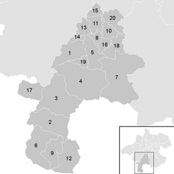
The Gmunden district covers 1,432.52 km² and is divided into 20 communities , including three towns and seven market communities. The population figures are from January 1st, 2020.

| local community | location | Ew | km² | Ew / km² | Judicial district | region | Type
|
photo | Metadata |
|---|---|---|---|---|---|---|---|---|---|
Altmünster
|

|
9,856 | 78.77 | 125 | Gmunden | market community
|
.JPG)
|
According to code: 40701 |
|
Bad Goisern on Lake Hallstatt
|

|
7,560 | 112.26 | 67 | Bad Ischl | market community
|

|
Acc. To code: 40702 |
|
Bad Ischl
|

|
14,070 | 163.06 | 86 | Bad Ischl | urban community
|

|
Gem.Kennz .: 40703 |
|
Ebensee on the Traunsee
|

|
7,677 | 194.66 | 39 | Bad Ischl | market community
|

|
Acc. To code: 40704 |
|
Gmunden
|

|
13,275 | 63.55 | 209 | Gmunden | urban community
|

|
Acc. To code: 40705 |
|
Gosau
|

|
1,794 | 113.4 | 16 | Bad Ischl | local community
|

|
According to code: 40706 |
|
Grünau im Almtal
|

|
2,060 | 230.18 | 8.9 | Gmunden | local community
|

|
Acc. To code: 40707 |
|
Gschwandt
|

|
2,828 | 16.74 | 169 | Gmunden | local community
|

|
According to code: 40708 |
|
Hallstatt
|

|
754 | 59.72 | 13 | Bad Ischl | market community
|

|
According to code: 40709 |
|
Kirchham.svg)
|

|
2,188 | 28.36 | 77 | Gmunden | local community
|
Acc. To code: 40710 |
||
Laakirchen
|

|
9,843 | 32.46 | 303 | Gmunden | urban community
|

|
According to code: 40711 |
|
Obertraun
|

|
749 | 88.43 | 8.5 | Bad Ischl | local community
|

|
Acc. To code: 40712 |
|
Ohlsdorf
|

|
5,211 | 27.78 | 188 | Gmunden | local community
|

|
According to code: 40713 |
|
Pinsdorf
|

|
4.029 | 12.48 | 323 | Gmunden | local community
|

|
Acc. To code: 40714 |
|
Roitham am Traunfall
|

|
1,992 | 21.02 | 95 | Gmunden | local community
|

|
According to code: 40715 |
|
St. Conrad
|

|
1,144 | 19.29 | 59 | Gmunden | local community
|
According to code: 40716 |
||
St. Wolfgang in the Salzkammergut
|

|
2,802 | 56.43 | 50 | Bad Ischl | market community
|

|
Acc. To code: 40717 |
|
Scharnstein
|

|
4,871 | 47.84 | 102 | Gmunden | market community
|

|
According to code: 40719 |
|
Traunkirchen
|

|
1,632 | 18.33 | 89 | Gmunden | local community
|

|
Acc. To code: 40718 |
|
Vorchdorf
|

|
7,524 | 47.75 | 158 | Gmunden | market community
|

|
Acc. To code: 40720 |
Lakes
- Almsee 0.85 km²
- Gosau Lakes 0.52 km²
- Hallstätter See 8.55 km²
- Langbathseen 0.33 km²
- Laudachsee about 0.1 km²
- Nussensee 0.10 km²
- Smaller 0.03 km² and Großer Ödsee 0.08 km²
- Offensee 0.55 km²
- Schwarzensee 0.48 km²
- Traunsee 24.35 km²
- Wolfgangsee (small part of the Gmunden district; about 1.2 km²)
Focus
The main area of the Gmunden district is in the Ebensee cadastral municipality, Ebensee municipality ( ⊙ ).
Neighboring districts
| District of Vöcklabruck | District Wels-Land | Kirchdorf district |
| District Hallein , District Salzburg |
.svg)
|
|
| St. Johann im Pongau district | Liezen district |
Population development

Mountains (selection)
- Dachstein 2995 m (highest mountain in Upper Austria)
- Feuerkogel 1592 m
- Grünberg 1004 m
- Kasberg 1747 m
- Traunstein 1691 m
Personalities
- Thomas Bernhard (1931–1989), writer
- Leopold Engleitner (1905–2013), Nazi victim
Individual evidence
- ↑ Further information about the Gmunden district on the geographic information system of the federal state of Upper Austria . Retrieved July 11, 2015.
- ↑ Statistics Austria - Population at the beginning of 2002–2020 by municipalities (area status 01/01/2020)
- ↑ The largest lakes in the state in comparison. Office of Upper Austria. State government, accessed on July 11, 2015 .
- ↑ center point
Web links
Statutory cities: Linz | Steyr | catfish
Political districts: Braunau am Inn | Eferding | Free City | Gmunden | Grieskirchen | Kirchdorf | Linz-Land | Perg | Ried im Innkreis | Rohrbach | Schärding | Steyr-Land | Urfahr environment | Vöcklabruck | Catfish Land
Coordinates: 47 ° 55 ' N , 13 ° 48' E