
St. Johann im Pongau district
| location | |
|---|---|
  |
|
| Basic data | |
| state | Salzburg |
| NUTS III region | AT-322 |
| Administrative headquarters | St. Johann im Pongau |
| surface | 1755 km² |
| Residents | 81,194 (January 1, 2020) |
| Population density | 46 inhabitants / km² |
| License Plate | JO |
| District Commission | |
| District Captain | Harald Wimmer |
| website | BH St. Johann |
| map | |
  |
|
The district of St. Johann im Pongau is a political district of the State of Salzburg with an area of 1,754.91 km². It is congruent with the Pongau , one of the five districts of the state.
The name Pongau (Pongow, Pongowe) is first mentioned around 788 in the two earliest Salzburg registers of goods. It refers to the area around Bischofshofen , insofar as Duke Theudebert von Baiern donated the Cella Maximiliana (Maximilianszelle) there and the surrounding area within a radius of three Roman miles to the monastery of St. Peter in Salzburg around 711 . In the 12th century "Pongau" was probably also the name of the Bischofshofener castle. The name “Pongau” probably goes back to Roman times. In the 13th century, the Pongau as an administrative area (county, comites) - at that time probably owned by the Lords of Pongau, then (until 1243) the Gutrater - also included northern areas of the Tennengebirge around the entire mountain range, but still without the southern Gastein Valley .
geography
The district lies between the Pinzgau in the west, the Lungau in the southeast and the Tennengau in the north in the middle of the Alps. In the south it borders on the federal state of Carinthia and in the east to a small extent on Styria and over a few kilometers on Upper Austria . In the northwest there is also a border with the Bavarian district of Berchtesgadener Land .
Together with the Pinzgau and the Lungau, the Pongau belongs to the so-called Inner Mountains , a designation that characterizes the southern region of the state of Salzburg, especially from the point of view of the flatter parts of the Salzburg region.
Geographically, the St. Johann district dominates the upper Salzach valley. The Salzach flows here first in a west-east direction and bends north in a large arc between Schwarzach and St. Johann. The course of the valley is the district's main traffic artery; the two largest towns, St. Johann and Bischofshofen, are located here. North of the Salzach dominates the northern Alps belonging massif of High King , south of the river to the main Alpine ridge with the Central Alps belonging Hohe Tauern . Of the north-south running right side valleys of the Salzach, the most westerly Gastein Valley is the most important. Down the river follow the valley of the Großarler Ache (main town Großarl) and that of the Wagrainer Ache or the Kleinarler Bach , which continues to flow in a westerly direction at the level of the main town Wagrain. The subsequent Fritzbach also runs in an east-west direction; the narrow Fritzbachtal represents the connection to the easternmost part of the Pongau (capital Radstadt), which with the Flachauwinkl has a share in the uppermost Ennstal . The north of the district (main town Werfen) is determined by the rather inaccessible mountain groups Tennengebirge on the right and Hagengebirge on the left side of the Salzach.
history
From the beginning of the settlement to the 9th century
The very sparsely populated wooded Pongau probably belonged to the area of the first state structure on Austrian soil, the Kingdom of Noricum (2nd century to 15 BC). From 15 BC Until 476 the area belonged to the Roman Empire . The Celtic Ambisonts living there resisted the Roman submission and subsequent Romanization - ultimately unsuccessfully.
Around 45 AD the Romans created the province of Noricum for better control of the area . There are also traces of some villae rusticae in the mountains . In the 3rd / 4th In the 19th century (under the emperors Septimius Severus and Constantine ) the roads across the Alps were expanded for military purposes. From around 400 onwards, the migration of peoples affected the area of what is now Austria, on the Danube Limes, for example, clearly recognizable by the collapse of coin circulation . In 407 the Visigoths invaded Carinthia and moved to Italy, followed by Heruli, Rugians, Elbe-Germanic tribes, Alemanni, Huns, and later the Avars in eastern Austria. The extent to which these tribes also penetrated the mountain regions is (still) unclear. In the foothills of the Alps, for example, in Obereching and Piding , i.e. on the Salzach and Saalach, Bavarian finds attest to this development.
In the period from 476 to 488, the Italian king Odoacer also ruled Noricum. In 488 he recalled the Roman administration and soldiers from the untenable Noricum to Italy. In the following period (since 493) the area of the later Pongau belonged to the Ostrogoth Empire , but was left to the Franks in 536. In the years from 570 to 610 invasions from Bavaria or Lombards took place via South Tyrol into the Slavic- Late Norse Principality of Carantania . It is unclear whether this also affected the Pongau. Fights in Lungau cited. Fights against the Avars in Carinthia, some of whom were allied with the Slavs, are documented for the year 610 . During this time, the late antique Noric-Romanesque bishopric in Carinthia went under. By 820, the Slavic settlement areas extended to Lungau and Enns-Pongau.
In the year 711 the small Maximilianszelle was founded in Bischofshofen, at the same time as the Salzburg women's foundation Nonnberg . In the earliest documents, however, appearances of light in the village of Pongau are reported beforehand, which Rupert's emissaries observed and reported to the bishop. According to old Salzburg tradition, Abbot Rupert is set to die in 623, so that this would be the first erection of the cross in Pongau. It would have taken place around 600, i.e. around 100 years earlier than indicated in the usual representations.
From the 7th / 8th In the 17th century, the Duchy of Bavaria took over the rule in Pongau, with an interruption in the 8th / 9th. Century. The Salzburg church (St. Peter's monastery and the cathedral chapter ) became the landowners of large properties in Pongau under the Agilolfingers in the 8th century .
The Maximilianszelle in Bischofshofen was rebuilt around 750 under Bishop / Abbot Virgilius . Karantanien finally came under Bavarian rule in 772. The Salzburg Virgil Cathedral was inaugurated in 774, making Salzburg the second most important archbishopric in the Franconian Empire (next to Mainz) in 798 (under Charlemagne ), ahead of the dioceses of Passau, Regensburg and Freising and Saeben, all of which were subordinate to Salzburg.
After the time of Charlemagne, the Slavs again invaded the Pongau around 820. After the reconquest, the Maximilianszelle was built for the third time from Salzburg, and the Salzburg-Bavarian expansion into the mountains continued. This can be seen from the oldest old German Gothic land register and from field names. Only long after the Bavarian settlement in the foothills of the Alps, in the Innkreis and Salzachgau, was it possible to secure and settle the Pongau.
From the 11th to the 19th century
Hardly any written documents have survived from the late 9th to the 11th centuries. A church is mentioned around 924 (unclear whether in St. Johann or in the Altpfarre-Pfarrwerfen).
In 1074 the three original parishes in what would later become Pongau were first mentioned in a document. In the period from 1075 to 1078 the construction of Werfen Castle began , which was expanded around 50 years later (from 1127 to 1142). From documents it can be seen that between 1106 and 1215 a small Augustinian choir monastery was established in Bischofshofen . In addition, Bischofshofen (Hove) was an old Thaidingstätte , where according to old ("antiqua") laws, court was held.
Around 1180/90, the Counts of Plain are the owners of the counties of Kuchl-Pongau and Niederpinzgau until 1219 (after Zillner).
The county then apparently falls to the archbishopric, the Gutrater are still count judges in Pongau until 1243. Then the county was dissolved. The Archbishopric Salzburg placed the Pongau under the care court of Werfen (with regional judges).
The lords of Pongau are the powerful and old Salzburg family as gifts from Pongau, of whom over 20 are named in the 12th century.
The Gastein Valley was a separate Bavarian county, a fiefdom of the Counts of Peilstein . In 1297 it fell to the Archbishopric of Salzburg.
When the Duchy of Bavaria recognized the Salzburg borders in 1275 and the Archbishopric of Salzburg in 1328, Salzburg became de jure independent of Bavaria. But there remained many small manors; For example, in 1792 there were well over 100 predominantly ecclesiastical manors in Pongau. The scattering of possessions and court marks (with bailiffs, carers, castlers ...) as well as overlapping secular and spiritual rights are characteristic of the complex medieval system of rule and administration.
After the local nobility (counts and ministerials ) of the Lords of Pongowe, Gutrather and Goldegger, in Gastein for example the Kuchler and Peilsteiner and the trade nobility , the entire area fell to the through purchase, donation and fiefdom until 1803 Archbishopric Salzburg.
In the era from 1803 to 1809, Salzburg became a German electorate. During the Napoleonic period , Pongau and Salzburg briefly belonged to Bavaria from 1810 to 1816 and, together with Salzburg, to Upper Austria from 1816 to 1848. In 1820 the nursing courts were reorganized (also in Pongau).
With the creation of a separate crown land of Salzburg in 1848 and the end of the system of mansions, a state constitution was enacted. From 1850 to 1868 it brought about a reorganization of the state administration, the separation of administration and jurisdiction and the creation of self-governing local communities.
The district administration was housed in Werfen from 1850 to 1867 and then moved to St. Johann im Pongau. In 1866 the four "districts" Werfen, St. Johann, Radstadt and Gastein are listed for the Pongau.
Since the 20th century
After Austria was annexed to Hitler's Germany in 1938, the district was renamed the Bischofshofen administrative district and on January 1, 1939, the Bischofshofen district . After the Second World War, the administrative unit was restored to its old form.
Former district captains
The former district captains were:
|
|
|
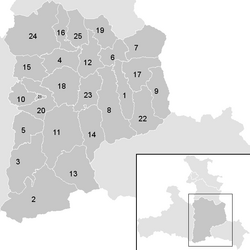
Administrative division
The St. Johann im Pongau district is divided into 25 communities . (The population figures are from January 1st, 2020):

All communities belong to the judicial district of Sankt Johann im Pongau . They are united in a regional association , the Regionalverband Pongau , for economic, structural and cultural promotion .
- Regions are Salzburg planning regions (according to the state development program)
| local community | location | Ew | km² | Ew / km² | Judicial district | region | Type | Metadata |
|---|---|---|---|---|---|---|---|---|
Altenmarkt im Pongau
|

|
4,428 | 48.6 | 91 | Sankt Johann im Pongau | PONGAU: Ennspongau (8) | market community |
Acc. To code: 50401 |
Bad Gastein
|

|
3,944 | 170.62 | 23 | Sankt Johann im Pongau | Pongau: Gastein Valley ( 10) | local community |
According to code: 50403 |
Bad Hofgastein
|

|
6,865 | 103.75 | 66 | Sankt Johann im Pongau | Pongau: Gastein Valley ( 10) | market community |
Acc. To code: 50402 |
Bischofshofen
|

|
10,580 | 49.54 | 214 | Sankt Johann im Pongau | PONGAU: Low Salzachpongau (7) | urban community |
According to code: 50404 |
Dorfgastein
|

|
1,622 | 54.13 | 30th | Sankt Johann im Pongau | Pongau: Gastein Valley ( 10) | local community |
According to code: 50405 |
In Pongau
|

|
2,545 | 35.93 | 71 | Sankt Johann im Pongau | PONGAU: Ennspongau (8) | local community |
Acc. To code: 50406 |
Filzmoos
|

|
1,513 | 75.65 | 20th | Sankt Johann im Pongau | PONGAU: Ennspongau (8) | local community |
Acc. To code: 50407 |
Flachau
|

|
2,876 | 117.33 | 25th | Sankt Johann im Pongau | PONGAU: Ennspongau (8) | local community |
Acc. To code: 50408 |
Forstau
|

|
551 | 59.45 | 9.3 | Sankt Johann im Pongau | PONGAU: Ennspongau (8) | local community |
According to code: 50409 |
Goldegg in Pongau
|

|
2,574 | 33.07 | 78 | Sankt Johann im Pongau | PONGAU: Upper Salzachpongau (9) | local community |
According to code: 50410 |
Grossarl
|

|
3,802 | 129.3 | 29 | Sankt Johann im Pongau | PONGAU: Upper Salzachpongau (9) | market community |
Acc. To code: 50411 |
Huettau
|

|
1,460 | 53.56 | 27 | Sankt Johann im Pongau | PONGAU: Ennspongau (8) | local community |
Acc. To code: 50412 |
Hüttschlag
|

|
909 | 97.24 | 9.3 | Sankt Johann im Pongau | PONGAU: Upper Salzachpongau (9) | local community |
According to code: 50413 |
Kleinarl
|

|
798 | 70.41 | 11 | Sankt Johann im Pongau | PONGAU: Ennspongau (8) | local community |
According to code: 50414 |
Mühlbach am Hochkönig
|

|
1,465 | 51.66 | 28 | Sankt Johann im Pongau | PONGAU: Low Salzachpongau (7) | local community |
Acc. To code: 50415 |
Parish throw
|

|
2,443 | 38.15 | 64 | Sankt Johann im Pongau | PONGAU: Low Salzachpongau (7) | local community |
According to code: 50416 |
Radstadt
|

|
4,876 | 60.84 | 80 | Sankt Johann im Pongau | PONGAU: Ennspongau (8) | urban community |
Acc. To code: 50417 |
St. Johann im Pongau
|

|
11,235 | 78.14 | 144 | Sankt Johann im Pongau | PONGAU: Upper Salzachpongau (9) | urban community |
Acc. To code: 50418 |
St. Martin am Tennengebirge
|

|
1,700 | 46.9 | 36 | Sankt Johann im Pongau | PONGAU: Ennspongau (8) | local community |
According to code: 50419 |
Sankt Veit im Pongau
|

|
3,846 | 56.9 | 68 | Sankt Johann im Pongau | PONGAU: Upper Salzachpongau (9) | market community |
According to code: 50420 |
Schwarzach im Pongau
|

|
3,493 | 3.2 | 1092 | Sankt Johann im Pongau | PONGAU: Upper Salzachpongau (9) | market community |
According to code: 50421 |
Untertauern
|

|
459 | 71.75 | 6.4 | Sankt Johann im Pongau | PONGAU: Ennspongau (8) | local community |
Acc. To code: 50422 |
Wagrain
|

|
3.121 | 50.54 | 62 | Sankt Johann im Pongau | PONGAU: Ennspongau (8) | market community |
According to code: 50423 |
Throw
|

|
3,058 | 153.26 | 20th | Sankt Johann im Pongau | PONGAU: Low Salzachpongau (7) | market community |
According to code: 50424 |
Werfenweng
|

|
1,031 | 45.01 | 23 | Sankt Johann im Pongau | PONGAU: Low Salzachpongau (7) | local community |
Acc. To code: 50425 |
Population development

literature
- Fritz Hörmann: The Pongau: 100 years of development in photo documents. Museum Association Werfen, Werfen, 1993.
- Fritz Hörmann: The Pongau: old pictures, historical plans (= series of publications by the Werfen Museum Association; 5). Edited by the Werfen Museum Association. Museum Association Werfen, Werfen, 1988, DNB 951411233 .
- Katharina Winckler: The Alps in the Early Middle Ages: The history of an area in the years 500 to 800. Böhlau, Vienna / Cologne / Weimar 2012, ISBN 978-3-205-78769-3 .
Web links
Individual evidence
- ↑ Michael Rademacher: German administrative history from the unification of the empire in 1871 to the reunification in 1990. District Bischofshofen. (Online material for the dissertation, Osnabrück 2006).
- ↑ District authority St. Johann im Pongau on Salzburgwiki from November 26th, accessed on November 26th, 2014
- ↑ Statistics Austria - Population at the beginning of 2002–2020 by municipalities (area status 01/01/2020)
-
↑ regional planning at www.salzburg.gv.at;
Planning region . In: Salzburger Nachrichten : Salzburgwiki .
Coordinates: 47 ° 18 ′ 0 ″ N , 13 ° 18 ′ 0 ″ E