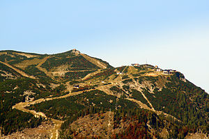
Feuerkogel (Höllengebirge)
| Feuerkogel | ||
|---|---|---|
|
View of the Feuerkogel |
||
| height | 1592 m above sea level A. | |
| location | Upper Austria , Austria | |
| Mountains | Hell Mountains | |
| Coordinates | 47 ° 48 '59 " N , 13 ° 43' 21" E | |
|
|
||
| Normal way | Hike | |
The Feuerkogel is a mountain west of Ebensee on the Traunsee in Upper Austria . Its height is 1592 m above sea level. A. It is located on the east of between Attersee and Traunsee running Höllengebirge and dominates the south shore of Lake Traun. The Höllengebirge is part of the northern Limestone Alps.
tourism
The Feuerkogel cable car has been leading up the mountain from Ebensee to the Feuerkogel mountain hotel since 1927 . This saves the ascent and thus facilitates tours to the Großer Höllkogel or the Höllengebirge crossing to the Hochleckenhaus , with the intermediate station Rieder Hütte . As early as 1936 there was one of the first ski lifts, the “Stangenlift” for approx. 8 people, not far below the Schanzhütte . Today, however, lift systems open up a total of 12 kilometers of ski slopes in winter. A very demanding 6 km long unprepared valley run leads from the mountain directly down to the local area of Ebensee.
Events
On the occasion of the 80th birthday of the cable car, a big festival and a traditional nostalgia race were held on March 3rd and 4th. On March 17, 2007 the “King of Kogl” was chosen at the freeride event. The Saukopfspringen took place on March 31st.
Every year in August, the sporting highlight is the mountain run on the Feuerkogel. The Feuerkogel mountain run is one of the mountain runs with the most participants in Austria. In 1997 the European Mountain Running Championships were held. Today the run is part of the Grand Prix mountain running series of the International Athletics Federation (IAAF).
Wind measurements on the Feuerkogel
A wind speed of 218 km / h was measured on the summit of the Feuerkogel on December 26, 1999 (Hurricane Lothar) . Due to the location, which is exposed from the northwest, the wind measuring station on the Feuerkogel repeatedly measures record values during Atlantic storms. In January 2007, during Hurricane Kyrill, the Austria-wide highest value of 207 km / h was measured.
climate
|
Average monthly temperatures and precipitation for Feuerkogel
|
|||||||||||||||||||||||||||||||||||||||||||||||||||||||||||||||||||||||||||||||||||||||||||||||||||||||||||||||||||||||||||||||||||||||||||||||||||||||||||||||||||||||||||||||||||||||||||||||||||
Web links
Individual evidence
- ↑ The hurricane "Lothar" caused millions in damages in Austria . wienerzeitung.at, December 28, 1999, accessed on August 24, 2013.

