
District Perg
| location | |
|---|---|
  |
|
| Basic data | |
| state | Upper Austria |
| NUTS III region | AT-313 |
| Administrative headquarters | Perg |
| surface | 613 km² |
| Residents | 68,968 (January 1, 2020) |
| Population density | 112 inhabitants / km² |
| License Plate | PE |
| District Commission | |
| District Captain | Werner Kreisl |
| website | www.bh-perg.gv.at |
| map | |
  |
|
The district of Perg is a political district of the state of Upper Austria .
geography
Location and limits
The district of Perg, the smallest of the four districts of the Mühlviertel , is located in the southeast of the Mühlviertel or in the southern part of the Lower Mühlviertel and extends from Luftenberg an der Donau in the west to Hirschenau in the municipality of St. Nikola an der Donau in the east. The geographic center is in the cadastral community of Innernstein in the market town of Münzbach at 361 m above sea level. A. The 26 parishes cover an area of 613,175,789.69 square meters and the perimeter is 197,519.29 meters.
The area of the district most recently with January 1, 1997 by streamlining the county line in Langenstein changed where the original to the City Enns in District Linz- owned site of the ruined castle Spielberg (Schlossau) due to the location north of the Danube with January 1, 1997 was assigned to the district of Perg.
The northernmost point is in St. Georgen am Walde . In the south the Danube forms the natural border. Only in Mitterkirchen im Machland does the district border continue to run along the previous river basin ( Danube oxbow ) even after the change in the course of the Danube (construction of the Wallsee-Mitterkirchen power plant ). In Luftenberg an der Donau, the Ausee area south of the Danube belongs to the Perg district.
Neighboring districts are the Urfahr-Umgebung district and the state capital Linz in the west, the Linz-Land and Amstetten districts in the south, the Melk and Zwettl districts in the east and the Freistadt district in the north .
Focus
The main area of the Perg district lies in the cadastral municipality of Innernstein , municipality of Münzbach ( ⊙ ).
geology
In the north, the Perg district comprises a strongly structured mountain and hill country (including Aist-Naarn-Kuppenland , Untermühlviertler Schollenland), some central layers with embedded basins and plains on the Danube. The high altitudes are foothills of the Bohemian massif with the Burstall in the municipality of St. Georgen am Walde as the highest point at 948 m above sea level. A. The parts of the district located in the Danube plains belong to the landscape region of the Alpine foothills . In the east of the district, on the Danube, there is also the lowest point of the district and, at the same time, Upper Austria at 220 m above sea level. A.
From a geological and geomorphological point of view as well as aspects of the use of space, the district of Perg belongs to 7 of the 41 spatial units of the federal state of Upper Austria .
- The Machland spatial unit includes parts of the following communities: Arbing, Baumgartenberg, Grein, Mauthausen, Mitterkirchen im Machland, Naarn im Machlande, Ried in der Riedmark, Saxen and Schwertberg.
- The Aist-Naarn-Kuppenland spatial unit includes parts of the following communities: Allerheiligen im Mühlkreis, Arbing, Bad Kreuzen, Baumgartenberg, Dimbach, Grein, Klam, Münzbach, Pabneukirchen, Perg, Rechberg, Ried in der Riedmark, St. Georgen am Walde, St. Nikola on the Danube, St. Thomas on the bladder stone, Schwertberg, Waldhausen im Strudengau and Windhaag near Perg.
- For room unit Southern Mühlviertler peripheral areas include parts of the following communities: Arbing, Baumgartenberg, Grein, Katsdorf, Klam, Langenstein, Luftenberg an der Donau, Mauthausen, Münzbach, Perg, Ried in Ried Mark, St. Georgen an der Gusen, Saxen, Schwertberg and wind Hague at Perg.
- The Danube Gorge and Side Valleys spatial unit includes parts of the following communities: Grein, St. Nikola an der Donau and Waldhausen im Strudengau.
- The Linzer Feld spatial unit includes parts of the following communities: Langenstein, Luftenberg an der Donau, Mauthausen and St. Georgen an der Gusen.
- Parts of the following communities belong to the Freiwald and Weinsberger Wald spatial unit : Parts of the communities of Dimbach, St. Georgen am Walde and Waldhausen im Strudengau.
- Parts of the following communities belong to the Central Mühlviertler Hochland spatial unit : Allerheiligen im Mühlkreis, Luftenberg an der Donau, Mauthausen, Ried in der Riedmark, St. Georgen an der Gusen.
In the south of the district in particular, granite , sandstone and kaolin are usable raw materials , which is why mining in granite and sandstone quarries and kaolin mining from All Saints' Day have played an economic role for centuries .
In the district of Perg, some granite stone formations, so-called wool sack weathering , are designated as natural monuments .
Waters
From Grein to Ybbs, the Danube has created a 25-kilometer-long breakthrough valley, the Strudengau. The tributaries also cut deep into the foothills of the granite massif on their way to the Danube. Such breakthrough valleys are for example the Gusental, the Aisttal (= Josefstal), the Naarntal, the Klamschlucht of the Klambach, the Stillensteinklamm of the Gießenbach etc.
All flowing waters in the Perg district drain to the Danube. The most important rivers include the Gusen (Große Gusen, Kleine Gusen), the Riederbach , the Aist ( Feldaist , Waldaist ), the Naarn (Große Naarn, Kleine Naarn), the Klambach , the Kämpbach, the Gießenbach , the Dimbach, the Sarmingbach and the little Isper .
In the Perg district, some lakes have been created that are also suitable for swimming. The Mitterkirchen bathing lake and the Ausee in Luftenberg an der Donau are former gravel pits fed by groundwater , the bathing lakes in Rechberg and Waldhausen are hamlets created by the damming of streams .
The waters were often used by fishing , on the Aist, Naarn and Sarmingbach from the 18th century for the flood of failure and from the 20th century for power generation by small hydropower plants .
The south of the Perg district was affected by flood disasters in the 20th and 21st centuries, as in previous centuries (see main article Perger Au ). In July 1954 and August 2002, when the water levels were sometimes higher than in 1954, there was considerable flooding from the streams, rivers and their tributaries flowing from the north to the Danube, caused by prolonged rainfall in the hinterland. In particular, the Naarn valley and the Josef valley had to be extensively renovated due to the flood damage in 2002/2003.
The flood protection project Machland Nord , also called Machland Dam, protects seven municipalities in Machland in Upper Austria and in Strudengau in Upper Austria from further flood disasters of up to one hundred years on the left of the Danube between Mauthausen and St. Nikola an der Donau in 2012 over a length of 36.4 kilometers . The project was the largest of around four hundred Austrian flood protection projects. At the same time it was the largest flood protection program in Central Europe and the history of Upper Austria .
climate
Both oceanic and continental climatic features are noticeable in the Perg district. From 1946 Robert Zinterhof ran a climate station in Pabneukirchen on a voluntary basis for more than 50 years and reported the values he read three times a day to the Central Institute in Vienna. The station's task was to research the mean weather conditions and the weather patterns over the months and years for the Lower Mühlviertel.
The eastern Mühlviertel is very sunny and has a milder climate than the central and western Mühlviertel. The annual mean air temperature is 7.2 degrees Celsius and the average rainfall is 880 liters per square meter. The highest recorded temperature was measured on July 5, 1950 with 37.5 degrees Celsius and the lowest temperature with -26.9 degrees Celsius on February 10, 1956. The highest annual precipitation in 1974 was 1150 mm and the highest daily precipitation on July 23, 1957 was 56 mm.
jurisdiction
District Courts
- Grein judicial district (until December 31, 2002)
- Mauthausen judicial district (until December 31, 2013)
- Perg judicial district
history
The historical development in the area of today's Perg district is described in detail, especially in the respective local articles. In addition, reference is made to the historical parts in the articles about the Riedmark , the Machland and the Machlandviertel as well as the articles on the numerous castles, palaces, churches and monasteries. The historically significant people in the district include: a. Otto von Machland and the Lords of Perg and Machland , Ulrich II. Von Kapellen , the Kapeller , Konrad von Waldhausen , Ladislaus Prager , Lorenz Schütter , Georg Erasmus von Tschernembl , Leonhard Helfried von Meggau , Martin Aichinger , Thomas Lansius , Joachim Enzmilner , Eva Magdalena Enzmilner , Bishop Josephus Calasanz Fließer .
District Commission, District Court
When the manorial or patrimonial administration was abolished in 1848 and the district offices with their rulership and district commissariats were dissolved, they were replaced by Lieutenancies with newly created district authorities. The district authority for the district of Perg with the official seat in Grein was one of 12 in the country ob der Enns and was established in 1850, but only existed until 1854. After various unsuccessful restructuring in the sense of neo-absolutism , one of 12 district authorities was established in 1868 for the district of Perg Seat established in the municipality of Perg.
In addition to the judicial district Grein , judicial district Mauthausen and judicial district Perg , this district also included the judicial district Pregarten , which was added to the Freistadt district in 1903 as part of the establishment of the Urfahr district administration . At that time the district covered 815.22 square kilometers and in 1890 had 53,730 inhabitants (of which 26,155 were male and 27,575 female). There were 58 communities with 388 localities. The judicial district of Perg covered 19.57 square kilometers and had 12,915 inhabitants.
In 1938, after Austria was incorporated into the German Reich, the district authorities were converted into district offices. After the war in 1945, the previous state was restored. On May 25, 1945, the state of Lower Austria temporarily took over the Perg district in its administration and appointed its own district captain. Only after the conclusion of the treaty of the settled and after completion in Urfahr and state Deputy Governor John Blöchl led civil administration Mühlviertel could on January 1, 1956 Upper Austrian provincial government begin its official business in the Bezirkshauptmannschaft Perg.
On January 1, 2003, the Grein District Court was closed. The municipalities of the dissolved judicial district (Bad Kreuzen, Dimbach, Grein, Klam, Pabneukirchen, St. Georgen am Walde, St. Nikola an der Donau, St. Thomas am Blasenstein, Saxen and Waldhausen im Strudengau) were assigned to the judicial district of Perg. The ten mentioned municipalities of the former judicial district Grein have since come under the control of the Amstetten land surveying office.
On January 1, 2014, the Mauthausen District Court was closed. All parishes of the dissolved judicial district were assigned to the judicial district of Perg.
- District captains of Perg
(Duration of the function in brackets)
- Eduard Kaim, lawyer, district captain of Grein on the Danube, knight of the ducal Saxony-Coburg-Ernestine house order, honorary citizen of Grein (1848 to 1854)
- Theodor Altwirt (from 1868)
- Josef Edler von Hueber (until 1879)
- August Wiesinger (1879 to 1890)
- Karl Binder (1890 to 1894)
- Ferdinand Ripelly (1894 to 1898)
- Rudolf Wacha (1898 to 1901)
- Karl Bihler (1901 to 1909)
- Johann Schusser (1909 to 1919)
- Alexander Rogler (1919 to 1920)
- Ernst Hodel (1920)
- Franz Rienmüller (1920 to 1938)
- Gustav Brachmann (1938 to 1941)
- Karl Korher (1942 to 1942)
- Ludwig Riebesam, General (1942 to 1945)
- Gottfried Haffner (1945 to 1946)
- Wilhelm Baselli (1946 to 1954)
- Matthäus Müller (1954 to 1959)
- Walter Endrich (1959 to 1973)
- Johann Zweckmair (1974 to 1990)
- Heinz Steinkellner (1990 to 2011)
- Werner Kreisel (since 2011)
Administrative division
The district of Perg is divided into 26 municipalities . Among these 26 political communities are two cities and 18 market communities. The population figures are from January 1st, 2020.

|
||
|
Legend for the breakdown table
|
| local community | location | Ew | km² | Ew / km² | Judicial district | region | Type
|
photo | Metadata |
|---|---|---|---|---|---|---|---|---|---|
All Saints' Day in the Mühlkreis
|

|
1,267 | 20.23 | 63 | Perg | local community
|

|
According to code: 41101 |
|
Arbing
|

|
1,507 | 12.01 | 125 | Perg | local community
|
.JPG)
|
According to code: 41102 |
|
Bad crosses
|

|
2,291 | 39.9 | 57 | Perg | market community
|

|
According to code: 41108 |
|
Baumgartenberg
|

|
1,789 | 15.71 | 114 | Perg | market community
|

|
According to code: 41103 |
|
Dimbach
|

|
965 | 31.27 | 31 | Perg | market community
|

|
According to code: 41104 |
|
Grein
|

|
2,910 | 18.42 | 158 | Perg | urban community
|

|
According to code: 41105 |
|
Katsdorf
|

|
3,182 | 14.61 | 218 | Perg | local community
|

|
Acc. To code: 41106 |
|
Klam
|

|
940 | 8.35 | 113 | Perg | market community
|

|
According to code: 41107 |
|
Langenstein
|

|
2,502 | 12.32 | 203 | Perg | local community
|

|
According to code: 41109 |
|
Luftenberg on the Danube
|

|
4,279 | 16.86 | 254 | Perg | market community
|

|
According to code: 41110 |
|
Mauthausen
|

|
4,924 | 14.03 | 351 | Perg | market community
|

|
According to code: 41111 |
|
Mitterkirchen in Machland
|

|
1,716 | 28.85 | 59 | Perg | market community
|

|
According to code: 41112 |
|
Münzbach
|

|
1,808 | 24.86 | 73 | Perg | market community
|

|
According to code: 41113 |
|
Naarn in the Machlande
|

|
3,708 | 35.13 | 106 | Perg | market community
|

|
According to code: 41114 |
|
Pabneukirchen
|

|
1,694 | 40.92 | 41 | Perg | market community
|

|
According to code: 41115 |
|
Perg
|

|
8,837 | 26.46 | 334 | Perg | urban community
|

|
According to code: 41116 |
|
Rechberg
|

|
1.006 | 13.75 | 73 | Perg | local community
|

|
According to code: 41117 |
|
Ried in the Riedmark
|

|
4,307 | 32.63 | 132 | Perg | market community
|

|
According to code: 41118 |
|
Saxen
|

|
1,756 | 19th | 92 | Perg | market community
|

|
According to code: 41123 |
|
Schwertberg
|

|
5,321 | 18.79 | 283 | Perg | market community
|

|
According to code: 41124 |
|
St. Georgen am Walde
|

|
1.965 | 53.59 | 37 | Perg | market community
|

|
According to code: 41119 |
|
St. Georgen an der Gusen
|

|
4,262 | 7.09 | 601 | Perg | market community
|

|
According to code: 41120 |
|
St. Nikola on the Danube
|

|
762 | 13.12 | 58 | Perg | market community
|
|
According to code: 41121 |
|
St. Thomas on the bladder stone
|

|
911 | 28.98 | 31 | Perg | market community
|

|
According to code: 41122 |
|
Waldhausen im Strudengau
|

|
2,853 | 46.69 | 61 | Perg | market community
|

|
According to code: 41125 |
|
Windhaag near Perg
|

|
1,506 | 19.12 | 79 | Perg | local community
|

|
According to code: 41126 |
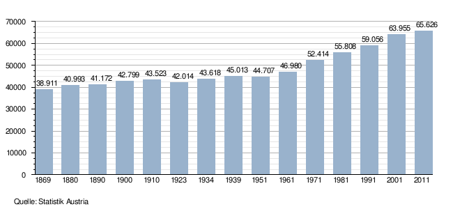
Population development
Church administrative units
Starting from the Taufkirchen Naarn, Ried and Saxen, which were equipped with basilicas in the 10th century, the deaneries developed as an ecclesiastical administrative unit first of the diocese of Passau and, from 1784, of the diocese of Linz .
Both the monasteries in Baumgartenberg and Waldhausen , founded by Otto von Machland in the 12th century, as well as the Dominican monasteries in Windhaag and Münzbach , established as part of the Counter-Reformation , were closed in the course of the Josephine reforms and their property transferred to the cathedral chapter of the newly founded diocese of Linz.
Only the Baumgartenberg Monastery was chosen as a settlement around the middle of the 19th century, first by the Jesuits , later by the Franciscans and then by the Sisters of the Good Shepherd .
After the separation from the Diocese of Passau in 1783/85, the parishes of the Perg district belonged to the deaneries Grein, Pabneukirchen and Pregarten. In 1974, the dean's offices and the boundaries of the dean's office were reallocated:
Since then, 10 parishes have belonged to the Grein dean's office in the Perg district (Bad Kreuzen, Dimbach, Grein, Klam, Pabneukirchen, St. Georgen am Wald, St. Nikola an der Donau, St. Thomas am bladder stone, Saxen and Waldhausen) and 12 to the dean's office Perg Parishes (Allerheiligen, Arbing, Baumgartenberg, Mauthausen, Mitterkirchen, Münzbach, Naarn, Perg, Pergkirchen, Rechberg, Schwertberg and Windhaag) and in addition to the parishes from other districts 3 parishes (Katsdorf, Ried in der Riedmark and St. Georgen to the Pregarten deanery ) the Gusen).
Parish churches: St. Andreas (Mitterkirchen) | St. James the Elder (Parish Church of Perg) | St. John dT (Arbing) | Hll. Laurentius u. Leonhard (Münzbach) | St. Maria Magdalena (Windhaag near Perg) | St. Martin (Pergkirchen) | St. Michael (Naarn) | St. Nicholas (Mauthausen) | St. Nicholas (Rechberg) | Hll. Philip et al. Jakobus (Schwertberg) • | • Assumption of Mary (former collegiate church Baumgartenberg) | UlF Queen of All Saints (Pilgrimage Church of All Saints)
Filial churches: Holy Cross (Kalvarienbergkirche Perg) • | • Hl. Ap. Bartholomäus (Altenburg) • | • Coronation of the Virgin Mary (pilgrimage church Maria Laab)
Mess chapels, chapels: Holy Cross (in the Münzbach cemetery, Tintische crypt chapel) | Holy Cross (Sword Mountain Calvary Chapel) • | • All Saints (Innernstein Castle Chapel) | St. Francis (Arbing) | St. Nicholas (Flößerkapelle Au) • | • Maria, Sl. Jungfrau (Schwertberg Castle Chapel) • | • Castle Chapel (Auhof) | Heiligenstein Chapel (All Saints' Day) | Heinrichskapelle (Mauthausen)
Order branches: Monastery of the Good Shepherd RGS (Baumgartenberg, former Cistercian monastery)
economy
The economic structure is predominantly industrial and commercial. Construction and mechanical engineering are dominant. A third of the approximately 2,300 companies are located in the Mauthausen - Schwertberg - Perg triangle . The three municipalities have the highest degree of industrialization in the Mühlviertel. 41% of those in employment have their job outside of the district, and by far the greatest number of commuters work in Linz. The trend of the jobs offered in the district is increasing.
18 municipalities in the district worked together in the LEADER Region Strudengau from 2007 to 2013 , one municipality belongs to the Leader Region Mühlviertler Alm , and seven municipalities have not yet joined any regional association.
The district of Perg is the only district in Austria with two Danube power plants. ( Wallsee-Mitterkirchen power plant and Abhaben-Asten power plant ). The Danube forms with few exceptions, the southern boundary of the district and between Mauthausen and St. Nikola an der Donau the border between Upper and Lower Austria. In the Perg district, in addition to the power plants already mentioned, it also forms the storage space for the Ybbs-Persenbeug power plant .
In the funding period from 2014 to 2020, the LEADER region was expanded by a further 6 to 24 municipalities in the Perg district, with the name also being changed to the Perg-Strudengau region in this context.

All Saints' Day | Arbing | Bad Kreuzen | Baumgartenberg | Dimbach | Grein | Katsdorf | Klam | Langenstein | Mauthausen | Mitterkirchen | Münzbach | Naarn Pabneukirchen | Perg | Rechberg | Ried in der Riedmark | Saxen | Schwertberg | St. Georgen an der Gusen | St. Nikola | St. Thomas | Waldhausen | Windhaag
LEADER, Agenda 21 region and association: Bad Zell | Kaltenberg | Königswiesen | Liebenau | Pierbach | Schönau im Mkr. | St. Georgen aW | St. Leonhard bF | Unterweißbach | Weitersfelden
Tourism region (association): Kaltenberg | Liebenau | Pierbach | Schönau im Mkr. | St. Georgen aW | St. Leonhard bF | Unterweißbach | Weitersfelden
Culture
Monument protection
In the district, 150 objects are protected by ordinance and 70 by decision of the Federal Monuments Office.
Museums
The district of Perg has a number of museums with very different collections. There are also some open-air museums. Some of the museums in the Perg district are networked in the regional museum association Museumsland Donauland Strudengau. Under the title Radkultour, some tourist bike routes have been signposted that lead directly to the region's museums. Most belong to the association of Upper Austrian museums . Some of the museums are located on the Danube Cycle Path or on the Donausteig and are therefore well known beyond the region.
| designation | place | category | Collection focus | Museum on the cycle path network | Museum association | Homepage |
|---|---|---|---|---|---|---|
| Apothecary Museum Mauthausen in Pragstein Castle | Mauthausen | Special museum | Health, trade, science | Danube Cycle Path | Museum land Donauland Strudengau | Mauthausen Pharmacist Museum |
| Castle Museum Clam | Klam | History museum | History, health, trade, art, applied arts, militaria, music, people, folklore, everyday culture | Danube Cycle Path | Museum land Donauland Strudengau | Castle Clam |
| Großdöllnerhof open-air museum | Rechberg | open air museum | Agriculture, nature, folklore, everyday culture | Danube Cycle Path (distance 15 km) | Museumsland Donauland Strudengau, Association of Upper Austrian Open-Air Museums | Großdöllnerhof Rechberg |
| Open-air museum Keltendorf Mitterkirchen | Mitterkirchen | Open-air museum, special museum | archeology | Danube Cycle Path | Museumsland Donauland Strudengau, Association of Upper Austrian Open-Air Museums | Celtic village Mitterkirchen |
| Heimathaus St. Georgen / Gusen | St. Georgen an der Gusen | Local museum | Archeology, history, handicrafts, agriculture, folklore, everyday culture, contemporary history | Danube Cycle Path | Gusen | |
| Heimathaus-Stadtmuseum Perg with the outdoor facilities Mühlsteinbruch Scherer , Erdstall Ratgöbluckn and Steinbrecherhaus | Perg | History museum, local history museum | Archeology, history, trade, craft, applied arts, agriculture, nature, people, folklore, everyday culture, contemporary history | Danube Cycle Path | Museum land Donauland Strudengau | Heimatmuseum-Stadtmuseum Perg |
| Heimathaus Mauthausen and trophy museum in Pragstein Castle | Mauthausen | Local museum | Archeology, history, handicrafts, art, applied arts, militaria, people, transport, folklore, everyday culture | Danube Cycle Path | Museum land Donauland Strudengau | Homeland Association Mauthausen |
| Heimatstube Pabneukirchen | Pabneukirchen | Local museum | Trade, craft, agriculture, folklore, everyday culture | Pabneukirchen | ||
| Card and local history museum Katsdorf | Katsdorf | Local museum | Archeology, history, trade, craft, agriculture, militaria, technology, history of technology, folklore, everyday culture | Heimatverein Katsdorf | ||
| Concentration camp memorial | Mauthausen | Special museum | History, contemporary history | Danube Cycle Path | Mauthausen Memorial | |
| Museum Altenburg - The Count of Windhaag with the Enzmilner Kulturwanderweg | Altenburg , Windhaag near Perg | History museum | History, people | Museum land Donauland Strudengau | Windhaag near Perg | |
| Upper Austria. Maritime Museum in Greinburg Castle | Grein | Special museum | Technology, history of technology, transport, traffic, folklore, everyday culture | Danube Cycle Path | Museum land Donauland Strudengau | Greinburg Castle |
| Strindberg Museum Saxen | Saxen | Special museum | Literature, people | Danube Cycle Path | Museum land Donauland Strudengau | Strindberg Museum Saxen |
Other museums in the Perg district include the Sankt Thomas am Blasenstein dollhouse museum, Oldy Kai, the somewhat different private museum, etc.
literature
- Association for the publication of a district homeland book Perg - communities of the district Perg (ed.): Our home - The district Perg. Linz 1995 and 1996, design of the district logo: Herbert Hiesmayr , editors: Heinz Steinkellner, Erwin Hölzl, Martin Lehner, Erwin Kastner, lecturers : Erwin Hölzl, Alexander Schachl. The authors of the articles on the individual municipalities of the district are given in brackets below:
- All Saints' Day in the Mühlkreis - place of pilgrimage and excursion (Martin Lehner)
- Arbing - defense tower on the northern edge of the Machland (Anton Kranzl)
- Bad Kreuzen - Kneipp cure and relaxation area (Gerhard Rumetshofer)
- Baumgartenberg - economy and culture in harmony (Karl Gusenbauer)
- Dimbach - Maria amgrün Anger - a place of pilgrimage - new on the rise (Karl Hahn)
- Grein - The Danube Town in Strudengau (Leopold Höller)
- Katsdorf - A growing community (Hubert Wöckinger)
- Klam - Portrait of a community (Josef Fraundorfer)
- Langenstein - resort on the Danube (Sonja Neundlinger, Johann Klinger)
- Luftenberg an der Donau - Live and feel good on the outskirts of Linz (Erhard Wansch)
- Mauthausen an der Donau - The European tourist community on the Danube Cycle Path (Johann Pirklbauer)
- Mitterkirchen - Hallstatt period open-air museum (Josef Riesenberger)
- Münzbach - worth living for each individual (Karl Schmidtberger)
- Naarn im Machlande - A paradise for cyclists (Josef Froschauer)
- Pabneukirchen - bread and furniture from the hill country (Robert Zinterhof, Karl Leitner)
- Perg - The city with a heart (Alexander Schachl)
- Rechberg - The recreational village on the lake (Fritz Jahn)
- Ried in der Riedmark - residential, settlement and agricultural community (Josef Landl)
- St. Georgen am Walde - The European Community (Lothar Grubich)
- St. Georgen an der Gusen - westernmost market in the district ( Rudolf A. Haunschmied )
- St. Nikola an der Donau - tourism community in Strudengau
- St. Thomas am Blasenstein - Committed to a great past ( Herbert Hiesmayr )
- Saxen - summer residence of the storks (Josef Abentheuer)
- Schwertberg - Where the hill country and the Danube plain meet (Josef Puchner)
- Waldhausen im Strudengau - recreation and culture (Waltraud Kaiserreiner)
- Windhaag near Perg - where the lords of the castle and palace once ruled (Wilhelm Burghofer)
- Cross-community articles in the order listed in the book:
- Alexander Schachl: Geographical overview
- Hermann Kohl, Robert Zinterhof: The climate
- Leopold Mayböck : prehistory and early history, the territorial development of the Machländer area, the Machländer area and its history, the high free of Perg / Machland and Velburg / Klam, old streets and mule tracks in the lower MNühlviertel
- Siegfried Haider : The Machland - the cradle of our national coat of arms
- Georg Clam Martinic : castles, palaces, mansions and ruins
- Karl Hohensinner: Settlement and farm names - signposts in history
- Ernst Gusenbauer: Warlike events, highlights from a time out of joint
- Rudolf Haunschmied : Gusen concentration camp
- Bernhard Gruber: Geology, Danube's lifeline
- Wolfgang Schachenhofer: Granite shapes the landscape, The Strudengau, Where the economy once flourished - Flood of wood on the Naarn, customs and traditions
- Josef Stummer: Granite
- Martin Lehner: Kaolin - White Earth from All Saints' Day, The Free Community - Foundations of the Free State
- Josef Promintzer: Living by and on the Danube
- Heinz Steinkellner: 145 years of district administration Perg
- Josef Dörsieb: Living in Security - The Gendarmerie - In the Service of Security
- Josef Kiesenhofer: The jurisdiction - historical development
- Erwin Hölzl: Education moves us forward
- Otto Gutenbrunner: Social affairs
- Leo Pochlatko: Red Cross
- Herta Aumayr: Health - Our greatest asset! - The health system in the Perg district
- Johann Hochgatterer: Fire Department
- Ferdinand Landl, Johann Hospodar, Franz Rummerstorfer: Economy and labor market
- Gerhard Angermayer: Our train
- Johann Pirklbauer: Postal system
- Johann Kastl, Helmut Opitz: The banks
- Anton Schwarz: Emergency money
- Josef Fraundorfer: This country is a feeling - tourism
- Albert Griesbacher: Agriculture and forestry then and now
- Martha Gammer : Painted Peasant Furniture - Production in the late 18th and early 19th centuries
- Löw-Baselli: The forest and forestry
- Ludwig Schönbeck: Hunting, nature and landscape protection
- Gerhard Reumann: The fishery in the district of Perg
- Johann Stöllnberger: Church and Religion
- Josef Grafeneder : A walk through the year
- Wolfgang Schachenhofer, August Weichselbaumer: In the realm of legends
- Ingeborg Glisic: gold bonnets - pearl bonnets - headscarf groups
- Karl Grufeneder: Brass music - an integral part of life in the Perg district
- Franz Achleitner: Sports in the Perg district
- Friedrich Buchmayr : August Strindberg and the Mühlviertel
Web links
- Homepage District Commission Perg
- Upper Austria. Landesarchiv Bezirkshauptmannschaft Perg
- District fire department Perg
- Province of Upper Austria Regional database District Perg
Individual evidence
- ↑ Inauguration of the new district captain in Perg. In: nachrichten.at. April 11, 2011, accessed May 22, 2020 .
- ↑ Center of the Perg district (PDF; 1.2 MB).
- ↑ center point
- ↑ Hermann Kohl: The lifeless nature . Upper Austrian provincial exhibition <1988, Kefermarkt>; Upper Austria. In: Helga Litschel, Province of Upper Austria, Office of Upper Austria. State government, culture department. (Ed.): The Mühlviertel: Nature, Culture, Life / Upper Austrian State Exhibition 1988, May 21 to October 30, 1988 in Weinberg Castle near Kefermarkt. Event from the state of Upper Austria. tape 2 . Province of Upper Austria, Office of Upper Austria. State government, Culture Department , Linz, DNB 551827696 , p. 41 ff .
- ^ Robert Zinterhof: Climate station Pabneukirchen. In: Our home in the district of Perg. Association for the publication of a district home book of Perg - communities of the district of Perg (publisher), Linz 1995, p. 18 f.
- ↑ Brockhaus´ Konversationslexikon 1902-1910 .
- ↑ 125 years of district authorities ( page no longer available , search in web archives ) Info: The link was automatically marked as defective. Please check the link according to the instructions and then remove this notice.
- ↑ Heinz Steinkellner: 145 years district administration Perg. In: Our home of the district Perg. Association for the publication of a district homeland book and communities of the district Perg (publisher), Linz, 1995, p. 164ff.
- ↑ Changes as of January 1, 2003 ( Memento of the original from November 2, 2012 in the Internet Archive ) Info: The archive link was inserted automatically and has not yet been checked. Please check the original and archive link according to the instructions and then remove this notice. at Statistics Austria.
- ↑ Land Surveying Office Linz
- ↑ Werner Kreisel: Performance report 150 years district administration Perg. Perg 2018.
- ↑ Statistics Austria - Population at the beginning of 2002–2020 by municipalities (area status 01/01/2020)
- ↑ Johann Stöllnberger: Church and religion. In: Our home in the district of Perg. Association for the publication of a district homeland book Perg - communities of the district of Perg (editor), Perg 1995.
- ↑ Rudolf Lehr: State Chronicle of Upper Austria. Vienna 2008, p. 14 f.
- ^ Website of the Perg-Strudengau region
- ↑ Museums of the Perg district in Upper Austria. Museum association
- ↑ Upper Austria. Museum association
- ↑ Bernhard Leitner: Josef Kaimüller. In: nachrichten.at. March 7, 2005, accessed May 22, 2020 .
Statutory cities: Linz | Steyr | catfish
Political districts: Braunau am Inn | Eferding | Free City | Gmunden | Grieskirchen | Kirchdorf | Linz-Land | Perg | Ried im Innkreis | Rohrbach | Schärding | Steyr-Land | Urfahr environment | Vöcklabruck | Catfish Land
Coordinates: 48 ° 15 ' N , 14 ° 38' E