
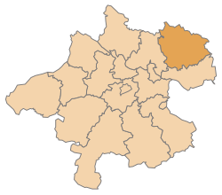
Freistadt district
| location | |
|---|---|
  |
|
| Basic data | |
| state | Upper Austria |
| NUTS III region | AT-313 |
| Administrative headquarters | Free City |
| surface | 994 km² |
| Residents | 66,861 (January 1, 2020) |
| Population density | 67 inhabitants / km² |
| License Plate | FR |
| District Commission | |
| District Captain | Alois Hochedlinger |
| website | www.bh-freistadt.gv.at |
| map | |
  |
|
The district of Freistadt is a political district of the province of Upper Austria .
It is located northeast of Linz and borders the Czech Republic in the north and the federal state of Lower Austria in the east . In the south it borders on the district of Perg and in the west on the district of Urfahr-Umgebung . According to the quarter division of Upper Austria, it belongs to the Mühlviertel with three other districts . The border with Lower Austria is a large, hardly populated forest area, the Weinsberg Forest .
history
The district was created in 1868. In 1903 the judicial district of Leonfelden was ceded to the newly created district of Urfahr-Umgebung. The judicial district of Pregarten from the district of Perg was added as a replacement . Between 1938 and 1960 the judicial district of Leonfelden was again part of the district.
Administrative division
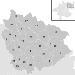
The district of Freistadt covers 994.1 km² and is divided into 27 municipalities , including two cities and 17 market communities. The indicated population figures are from January 1st, 2020.

| local community | location | Ew | km² | Ew / km² | Judicial district | region | Type
|
photo | Metadata |
|---|---|---|---|---|---|---|---|---|---|
Bad Zell
|

|
2,883 | 45.52 | 63 | Perg | market community
|

|
Acc. To code: 40627 |
|
Free City
|

|
7,981 | 12.86 | 621 | Free City | urban community
|

|
Acc. To code: 40601 |
|
Grünbach
|

|
1.937 | 36.08 | 54 | Free City | local community
|

|
Acc. To code: 40602 |
|
Gutau
|

|
2,735 | 45.28 | 60 | Free City | market community
|

|
Acc. To code: 40603 |
|
Hagenberg in the Mühlkreis
|

|
2,764 | 15.05 | 184 | Free City | market community
|
|
Acc. To code: 40604 |
|
Hirschbach in the Mühlkreis
|

|
1,180 | 23.63 | 50 | Free City | local community
|

|
Acc. To code: 40605 |
|
Kaltenberg
|

|
620 | 17.2 | 36 | Free City | local community
|

|
Acc. To code: 40606 |
|
Kefermarkt
|

|
2.136 | 27.81 | 77 | Free City | market community
|

|
Acc. To code: 40607 |
|
Königswiesen
|

|
3,083 | 73.38 | 42 | Perg | market community
|

|
Acc. To code: 40608 |
|
Lasberg
|

|
2,836 | 43.8 | 65 | Free City | market community
|

|
According to code: 40609 |
|
Leopoldschlag
|

|
1,001 | 25.8 | 39 | Free City | market community
|
According to code: 40610 |
||
Liebenau
|

|
1,561 | 76.31 | 20th | Free City | market community
|

|
Acc. To code: 40611 |
|
Neumarkt in the Mühlkreis
|

|
3,173 | 46.67 | 68 | Free City | market community
|

|
According to code: 40612 |
|
Pierbach
|

|
1,025 | 22.72 | 45 | Perg | local community
|

|
According to code: 40613 |
|
Pregarten
|

|
5,544 | 27.77 | 200 | Free City | urban community
|

|
Acc. To code: 40614 |
|
Rainbach in the Mühlkreis
|

|
2,987 | 49.27 | 61 | Free City | market community
|
According to code: 40615 |
||
Sandl
|

|
1,392 | 58.32 | 24 | Free City | local community
|

|
Acc. To code: 40616 |
|
St. Leonhard near Freistadt
|

|
1,370 | 35.01 | 39 | Free City | market community
|

|
According to code: 40617 |
|
St. Oswald near Freistadt
|

|
2,876 | 40.98 | 70 | Free City | market community
|
According to code: 40618 |
||
Schönau in the Mühlkreis
|

|
1,958 | 38.54 | 51 | Perg | local community
|

|
Acc. To code: 40619 |
|
Carrying wine
|

|
3.122 | 39.47 | 79 | Perg | market community
|

|
Acc. To code: 40620 |
|
Unterweißbach
|

|
2,171 | 48.73 | 45 | Free City | market community
|

|
According to code: 40621 |
|
Unterweitersdorf
|

|
2,181 | 11.42 | 191 | Free City | local community
|

|
According to code: 40622 |
|
Forest castle
|

|
1,404 | 26.53 | 53 | Free City | local community
|

|
According to code: 40623 |
|
Wartberg whether the Aist
|

|
4,308 | 19.41 | 222 | Free City | market community
|
|
Acc. To code: 40624 |
|
Weitersfelden
|

|
1,063 | 43.72 | 24 | Free City | market community
|

|
Acc. To code: 40625 |
|
Windhaag near Freistadt
|

|
1,570 | 42.83 | 37 | Free City | market community
|
According to code: 40626 |
Focus
The main area of the Freistadt district is in the Erdmannsdorf cadastral community , Gutau ( ⊙ ).
Population development

Web links
- District administration Freistadt
- Michael Rademacher: German administrative history from the unification of the empire in 1871 to the reunification in 1990. District of Freistadt (1939–1945). (Online material for the dissertation, Osnabrück 2006).
Individual evidence
- ↑ Provincial Law Gazette for Upper Austria, born 1960, Issue 10, No. 20: Ordinance of the Upper Austrian Provincial Government of 6 July 1959
- ↑ Statistics Austria - Population at the beginning of 2002–2020 by municipalities (area status 01/01/2020)
- ↑ center point
Statutory cities: Linz | Steyr | catfish
Political districts: Braunau am Inn | Eferding | Free City | Gmunden | Grieskirchen | Kirchdorf | Linz-Land | Perg | Ried im Innkreis | Rohrbach | Schärding | Steyr-Land | Urfahr environment | Vöcklabruck | Catfish Land
Coordinates: 48 ° 31 ' N , 14 ° 30' E