
Grieskirchen district
| location | |
|---|---|
  |
|
| Basic data | |
| state | Upper Austria |
| NUTS III region | AT-311 |
| Administrative headquarters | Grieskirchen |
| surface | 579 km² |
| Residents | 64,875 (January 1, 2020) |
| Population density | 112 inhabitants / km² |
| License Plate | GR |
| District Commission | |
| District Captain | Christoph Schweitzer |
| website |
www.bh-gries- kirchen.gv.at |
| map | |
  |
|
The political district of Grieskirchen is a political district of the Province of Upper Austria .
It is located in the Hausruckviertel northwest of Wels .
history
The district is the youngest in Upper Austria and was founded in 1911 (RGBl. No. 173/1911). For the district, the district authorities in Ried ceded the judicial district of Haag am Hausruck , Schärding the judicial district Peuerbach and Wels the judicial district Grieskirchen to the new district.
In 1923 the communities of Heiligenberg, Michaelnbach, St. Agatha, St. Thomas and Waizenkirchen of the abandoned judicial district of Waizenkirchen moved from the Eferding district to the Grieskirchen district. At the same time, the community of Geiersberg was assigned to the district of Ried im Innkreis on July 26, 1923 . From 1938 to 1948 the area of the Eferding district was added to the Grieskirchen district.
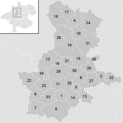
Administrative division
The Grieskirchen district covers 578.66 km² and has been divided into
- 33 municipalities ,
- including 2 cities
- and 14 market towns.

- The population figures are from January 1st, 2020.
| local community | location | Ew | km² | Ew / km² | Judicial district | region | Type | Metadata |
|---|---|---|---|---|---|---|---|---|
Aistersheim
|

|
921 | 11.1 | 83 | Grieskirchen | local community |
According to code: 40801 |
|
Bad Schallerbach
|

|
4.210 | 8.49 | 496 | Grieskirchen | market community |
Acc. To code: 40802 |
|
Eschenau in the Hausruckkreis
|

|
1,061 | 16.64 | 64 | Eferding | local community |
According to code: 40804 |
|
Gallspach
|

|
2,781 | 6.17 | 451 | Grieskirchen | market community |
Acc. To code: 40805 |
|
Gaspoltshofen
|

|
3,595 | 40.55 | 89 | Grieskirchen | market community |
Acc. To code: 40806 |
|
Geboltskirchen
|

|
1,445 | 17.22 | 84 | Grieskirchen | local community |
Acc. To code: 40807 |
|
Grieskirchen
|

|
4,987 | 11.74 | 425 | Grieskirchen | urban community |
According to code: 40808 |
|
Haag am Hausruck
|

|
2,201 | 16.97 | 130 | Grieskirchen | market community |
Acc. To code: 40809 |
|
Heiligenberg
|

|
702 | 13.86 | 51 | Eferding | local community |
According to code: 40810 |
|
Hofkirchen an der Trattnach
|

|
1,639 | 17.97 | 91 | Grieskirchen | market community |
According to code: 40811 |
|
Kallham
|

|
2,509 | 26.71 | 94 | Grieskirchen | local community |
Acc. To code: 40812 |
|
Kematen am Innbach
|

|
1,431 | 12.66 | 113 | Grieskirchen | market community |
According to code: 40813 |
|
Meggenhofen
|

|
1,530 | 18.2 | 84 | Grieskirchen | local community |
Acc. To code: 40814 |
|
Michaelnbach
|

|
1,268 | 23.01 | 55 | Grieskirchen | local community |
Acc. To code: 40815 |
|
Natternbach
|

|
2,287 | 30.96 | 74 | Eferding | market community |
According to code: 40816 |
|
Neukirchen am Walde
|

|
1,638 | 15.82 | 104 | Eferding | market community |
Acc. To code: 40817 |
|
Neumarkt in the Hausruckkreis
|

|
1,442 | 2.11 | 683 | Grieskirchen | market community |
According to code: 40818 |
|
Peuerbach
|

|
4,650 | 39.36 | 118 | Grieskirchen | urban community |
Acc. To code: 40835 |
|
Pollham
|

|
970 | 11.3 | 86 | Grieskirchen | local community |
According to code: 40821 |
|
Poetting
|

|
531 | 7.43 | 71 | Grieskirchen | local community |
According to code: 40820 |
|
Pram
|

|
1,638 | 20.31 | 81 | Grieskirchen | market community |
Acc. To code: 40822 |
|
Rottenbach
|

|
1,093 | 14.54 | 75 | Grieskirchen | local community |
According to code: 40823 |
|
Schlüßlberg
|

|
3,050 | 19.83 | 154 | Grieskirchen | market community |
According to code: 40827 |
|
St. Agatha
|

|
2.131 | 31.79 | 67 | Eferding | local community |
According to code: 40824 |
|
St. Georgen near Grieskirchen
|

|
1,340 | 11.41 | 117 | Grieskirchen | local community |
Acc. To code: 40825 |
|
St. Thomas
|

|
549 | 6.07 | 90 | Grieskirchen | local community |
Acc. To code: 40826 |
|
Steegen
|

|
1,064 | 13.2 | 81 | Grieskirchen | local community |
Acc. To code: 40828 |
|
Taufkirchen an der Trattnach
|

|
1,967 | 24.61 | 80 | Grieskirchen | market community |
According to code: 40829 |
|
Great
|

|
921 | 9.55 | 96 | Grieskirchen | local community |
According to code: 40830 |
|
Waizenkirchen
|

|
3,715 | 34.24 | 108 | Grieskirchen | market community |
Acc. To code: 40831 |
|
Wallern on the Trattnach
|

|
3,067 | 14.56 | 211 | Grieskirchen | market community |
According to code: 40832 |
|
Women
|

|
1,688 | 17.45 | 97 | Grieskirchen | local community |
According to code: 40833 |
|
Wendling
|

|
854 | 12.82 | 67 | Grieskirchen | local community |
Acc. To code: 40834 |
Focus
The main area of the Grieskirchen district lies exactly on the municipal boundary of Pötting and Taufkirchen an der Trattnach ( ⊙ ).
Population development

Web links
Individual evidence
- ↑ Statistics Austria - Population at the beginning of 2002–2020 by municipalities (area status 01/01/2020)
- ↑ center point
Statutory cities: Linz | Steyr | catfish
Political districts: Braunau am Inn | Eferding | Free City | Gmunden | Grieskirchen | Kirchdorf | Linz-Land | Perg | Ried im Innkreis | Rohrbach | Schärding | Steyr-Land | Urfahr environment | Vöcklabruck | Catfish Land
Coordinates: 48 ° 14 ' N , 13 ° 50' E