
Weibern (Upper Austria)
|
Women
|
||
|---|---|---|
| coat of arms | Austria map | |
 |
|
|
| Basic data | ||
| Country: | Austria | |
| State : | Upper Austria | |
| Political District : | Grieskirchen | |
| License plate : | GR | |
| Surface: | 17.45 km² | |
| Coordinates : | 48 ° 11 ' N , 13 ° 42' E | |
| Height : | 441 m above sea level A. | |
| Residents : | 1,688 (January 1, 2020) | |
| Population density : | 97 inhabitants per km² | |
| Postal code : | 4675 | |
| Area code : | 07732 | |
| Community code : | 4 08 33 | |
| NUTS region | AT311 | |
| Address of the municipal administration: |
Hauptstrasse 5 4675 Weibern |
|
| Website: | ||
| politics | ||
| Mayor : | Manfred Roitinger ( ÖVP ) | |
|
Municipal Council : (2015) (19 members) |
||
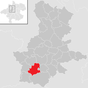
| Location of Weibern in the Grieskirchen district | ||
  |
||
| Source: Municipal data from Statistics Austria | ||

Weibern is a municipality in Upper Austria in the Grieskirchen district in the Hausruckviertel with 1688 inhabitants (as of January 1, 2020). The community is located in the judicial district of Grieskirchen .
geography
Weibern lies at an altitude of 441 m above sea level. A. in the Hausruckviertel . The extension is from north to south 5.6 km, from west to east 5.7 km. The total area is 17.4 km². 11.4% of the area is forested, 76% of the area is used for agriculture.
Community structure
The municipality includes the following 22 localities (population in brackets as of January 1, 2020):
- Growing up (23)
- Book (19)
- Dirisam (106)
- Einberg (24)
- Eitzenberg (20)
- Fox Stroke (10)
- Grolzham (114)
- Pit (24)
- Gudgeon (19)
- Hofreith (17)
- Niederndorf (86)
- Ortmanau (32)
- Pesendorf (82)
- Schachenreith (18)
- Schwarzgrub (171)
- Schwarzschachen (28)
- Seewiesen (28)
- Stublreith (28)
- Trattnach (20)
- Unterlehen (17)
- Untermeggenbach (88)
- Women (714)
The community consists of the cadastral communities Dirisam, Schwarzgrub and Weibern.
Neighboring communities
| Rottenbach | Hofkirchen | |
| Hague |
.svg)
|
Aistersheim |
| Geboltskirchen | Gaspoltshofen |
history
Originally located in the eastern part of the Duchy of Bavaria, the place belonged to the Duchy of Austria since the 12th century. Since 1490 it has been assigned to the Principality of Austria ob der Enns .
During the Napoleonic Wars , the place was occupied several times.
Since 1918 the place belongs to the federal state of Upper Austria. After the annexation of Austria to the German Reich on March 13, 1938, the place belonged to the Gau Oberdonau . After 1945 the restoration of Upper Austria took place.
The community has been part of the judicial district of Grieskirchen since January 1, 2003, previously it belonged to the judicial district of Haag am Hausruck .
Population development
In 1991 the community had 1,546 inhabitants according to the census, in 2001 then 1,581 inhabitants. The increase occurred despite emigration, as the birth balance was very positive. The balance of migration and the birth balance remained similar over the next decade, so that the population rose to 1,604 in 2011.
Culture and sights
music
The Trachtenkapelle von Weibern was founded over 150 years ago by Peter Wallaberger with 7 men and has been entertaining the inhabitants of Weibern with traditional music ever since. Today the music association, headed by Benedikt Eibelhuber, has 81 active members. In addition to the traditional costume band, Weibern also has a youth band together with the Geboltskirchen music association, the Music WG.
politics
Mayor is Manfred Roitinger from the ÖVP.
coat of arms
Blazon : Divided; a golden, stylized crown at the top in red, which ends at the bottom of the dividing line in the form of a double lintel rafter, at the top in the shield corners and between them in the middle in points; split at the bottom by blue and silver with two and a half right points. The community colors are red-yellow-blue.
The upper half of the municipal coat of arms awarded in 1972 shows a stylized "W" as the initial of the place name, the blue tips stand for the derivation of the name, which means "pond" ( ahd. Wiwari , from Latin vivarium ).
Personalities
Born in women
- Johann Roitinger (1846–1924), politician ( CSP )
- Augustin Roitinger (1909–1982), dialect poet and dialect interpreter
- Franz Roitinger (1906–1968), linguist
Web links
- Further information about the municipality of Weibern (Upper Austria) on the geographic information system of the federal state of Upper Austria .
Individual evidence
- ↑ Statistics Austria: Population on January 1st, 2020 by locality (area status on January 1st, 2020) , ( CSV )
- ↑ Statistics Austria, A look at the community of Weibern, population development. Retrieved April 12, 2019 .
- ^ Province of Upper Austria, results of the 2015 elections. Accessed on April 12, 2019 .
- ^ Herbert Erich Baumert: The coats of arms of the cities, markets and communities of Upper Austria (3rd supplement). In: Upper Austrian homeland sheets. Issue 1/2, 1973, p. 19 ( online (PDF) in the forum OoeGeschichte.at)

Aistersheim | Bad Schallerbach | Eschenau im Hausruckkreis | Gallspach | Gaspoltshofen | Geboltskirchen | Grieskirchen | Haag am Hausruck | Heiligenberg | Hofkirchen an der Trattnach | Kallham | Kematen am Innbach | Meggenhofen | Michaelnbach | Natternbach | Neukirchen am Walde | Neumarkt im Hausruckkreis | Peuerbach | Pollham | Pötting | Pram | Rottenbach | St. Agatha | St. Georgen near Grieskirchen | St. Thomas | Schlüßlberg | Steegen | Taufkirchen an der Trattnach | Great | Waizenkirchen | Wallern an der Trattnach | Women | Wendling