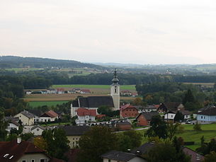
Taufkirchen an der Trattnach
|
market community Taufkirchen an der Trattnach
|
||
|---|---|---|
| coat of arms | Austria map | |
|
|
||
| Basic data | ||
| Country: | Austria | |
| State : | Upper Austria | |
| Political District : | Grieskirchen | |
| License plate : | GR | |
| Surface: | 24.61 km² | |
| Coordinates : | 48 ° 15 ' N , 13 ° 45' E | |
| Height : | 377 m above sea level A. | |
| Residents : | 1,967 (January 1, 2020) | |
| Postal code : | 4715 | |
| Area code : | 07734 | |
| Community code : | 4 08 29 | |
| NUTS region | AT311 | |
| Address of the municipal administration: |
Taufkirchen 105 4715 Taufkirchen an der Trattnach |
|
| Website: | ||
| politics | ||
| Mayor : | Gerhard Schaur ( ÖVP ) | |
|
Municipal Council : (2015) (25 members) |
||
| Location of Taufkirchen an der Trattnach in the Grieskirchen district | ||
 Taufkirchen an der Trattnach |
||
| Source: Municipal data from Statistics Austria | ||
Taufkirchen an der Trattnach is a municipality in Upper Austria in the Grieskirchen district in the Hausruckviertel with 1967 inhabitants (as of January 1, 2020). The community is located in the judicial district of Grieskirchen .
geography
Taufkirchen an der Trattnach lies at an altitude of 377 m above sea level. A. in the Hausruckviertel. The extension is 7 km from north to south and 6.6 km from west to east. The total area is 24.6 km², 13.8% of the area is forested, 77.6% of the area is used for agriculture.
Community structure
The municipality includes the following 37 localities (population in brackets as of January 1, 2020):
- Adrischendorf (16)
- Aich (213)
- Aichet (18)
- Altenhof (6)
- Brandstetten (31)
- Damberg (11)
- Dietensam (92)
- Eiblhub (18)
- Heir (4)
- Fellhof (4)
- Fürstling (5)
- Semolina (13)
- Grubhof (4)
- Gstötten (5)
- Haslau (27)
- Hehenberg (104)
- Helmling (32)
- Hofmaning (21)
- Wooden (6)
- Keneding (26)
- Korntnerberg (20)
- Moedlbach (51)
- Niedertrattnach (74)
- Oberolzing (18)
- Obertrattbach (9)
- Obertrattnach (311)
- Odlboding (34)
- Ring (35)
- Reischau (30)
- Roith (97)
- Taufkirchen an der Trattnach (385)
- Unterolzing (43)
- Untertrattbach (33)
- Paternal (47)
- Weidenau (5)
- Widldorf (103)
- Winkl (16)
The community consists of the cadastral communities Damberg, Keneding, Kortnerberg, Mödelbach, Roith and Widldorf.
Neighboring communities
| Kallham | Neumarkt | Poetting |
| Wendling |

|
Great |
| Hofkirchen | St. Georgen |
coat of arms
Blazon : "In silver over a blue wavy bar, a red rafter made up of two pieces of red bars and decorated with a red cross."
The community colors are red-white-blue.
The coat of arms, awarded in 1974, refers to the place name with a cross and waves, while the wave bar also stands for the Trattnach.
history
Roman roads led through Taufkirchen.
Timetable
| Year (s) | event |
|---|---|
| 785 | A priest named Selnrich gave his possessions in "dratihaha" (Trattnach-Obertrattnach) to the church. With the donation of this property in Trattnach to St. Stephen's Cathedral in Passau, an important cultural and legal historical event took place. |
| 1000 | Taufkirchen becomes the pastoral center of an extensive area. |
| 1088 | Roith Castle , one of the oldest noble residences , is mentioned for the first time in a document, although it was founded before the year 1000. |
| 1203 | First documentary mention of a noble residence in Vatersam. |
| 1260 | Taufkirchen an der Trattnach is first mentioned in a document. |
| 1293 | First documented mention of Höhenberg as Hehenberg . |
| 14th century | The Church of St. Vitus in Höhenberg is built in the Gothic style. |
| 1475 | The Church of St. James in Hinteraichet is first mentioned in a document. |
| 1516-1530 | In the parish land register there is talk of a schoolmaster. |
| from 1600 | Kallham becomes a parish and Taufkirchen is demoted to a vicariate. |
| 1620 | Roit Castle and the rectory burned down by Bavarian soldiers. |
| 1633 | In a Passau list, Taufkirchen appears again as a separate parish. |
| 1670-1980 | The church, built in the Romanesque architectural style, has a main nave built in the Renaissance style . |
| 1725 | Another renovation will give the church on the north side the Sebastiani chapel. |
| 1790 | The wooden school house is destroyed by fire and replaced by the first brick school house. |
| 1835 | The music band is brought into being. |
| 1850 | The first mayor is Johann Trinkfaß. |
| 1861 | With the opening of the Kaiserin-Elisabeth-Bahn , the community is connected to the European rail network. |
| 1870 | Establishment of the KK post office in Obertrattnach |
| 1886-1887 | The Lourdes Chapel in Aich is being built by the married couple Johann and Maria Hager at their own expense and property. |
| 1890 | Foundation of the Taufkirchen an der Trattnach volunteer fire brigade . |
| 1891 | Taufkirchen becomes an independent parish for the second time under canon law. |
| 1898 | The Raiffeisenkasse Taufkirchen is founded. |
| 1901 | Foundation of the music association |
| 1913 | The last remains of Roith Castle fall. |
| 1921 | Relocation of the post office to Taufkirchen. |
| 1950 | The parish hall will be built at the eastern entrance to the village. |
| 1958–1962 | Major exterior and interior renovation of the church |
| 1959 | The post office will be housed in the extension of the municipal office. |
| 1971 | Restoration of the rectory and adaptation of the farm building to a rectory |
| 1974 | October 7th - Award of the municipal coat of arms (decision of the Upper Austrian provincial government). Approval by the local council on August 28, 1974. |
| 1984 | Interior renovation of the parish church |
| 1985 | Taufkirchen an der Trattnach celebrates its 1200th anniversary. |
| 1994 | Blessing of the new organ |
| 2009 | Market survey |
Culture and sights
- The parish church in Taufkirchen an der Trattnach is consecrated to St. Martin (name day: November 11th). The parish Taufkirchen was subordinate to the Prince-Bishop of Passau for a long time and is now part of the Diocese of Linz .
- The branch and pilgrimage church Hehenberg (Höhenberg) is dedicated to St. Vitus (June 15) consecrated.
- The church in Roith (belonging to the moated castle Roith) was demolished during the Reformation by order of the emperor.
- The earthworks, the pond, which was drained in 1820, and the outbuildings remained of the former moated castle . Roith was a nursing dish . In 1956 the Counts Walderdorff came to Roith.
- The Steininger family of organ builders lived here for a long time. 17 organs and over a hundred new harmonies were built here.
Sons and daughters of the church
- Josef Krempl (born February 11, 1862; † April 4, 1914 in Vienna), dialect poet, was born in the village of Obertrattnach.
- Alois Gruber (born December 21, 1908 in Weidenau, † February 22, 1959 in Klagenfurt), politician, member of the National Council
- Franz Schiemer (* 1986), former soccer player and soccer champion a. a. with FC Red Bull Salzburg.
Web links
- Community website
- Background information on the story
- Map in the Digital Upper Austrian Room Information System ( DORIS )
- More information about the municipality of Taufkirchen an der Trattnach on the geo-information system of the federal state of Upper Austria .
Individual evidence
- ↑ Statistics Austria: Population on January 1st, 2020 by locality (area status on January 1st, 2020) , ( CSV )
- ↑ Herbert Erich Baumert: The coats of arms of the cities, markets and communities of Upper Austria (4th supplement 1973-1976) In: Oberösterreichische Heimatblätter, Heft 1/2, 1977, p. 27, online (PDF; 3.5 MB) in the forum OoeGeschichte.at


