
Pregarten
|
Borough Pregarten
|
||
|---|---|---|
| coat of arms | Austria map | |
 |
|
|
| Basic data | ||
| Country: | Austria | |
| State : | Upper Austria | |
| Political District : | Free City | |
| License plate : | FR | |
| Surface: | 27.77 km² | |
| Coordinates : | 48 ° 21 ' N , 14 ° 32' E | |
| Height : | 425 m above sea level A. | |
| Residents : | 5,544 (January 1, 2020) | |
| Postal code : | 4230 | |
| Area code : | 07236 | |
| Community code : | 4 06 14 | |
| NUTS region | AT313 | |
| UN / LOCODE | AT PGN | |
| Address of the municipal administration: |
Stadtplatz 12 4230 Pregarten |
|
| Website: | ||
| politics | ||
| Mayor : | Anton Scheuwimmer ( ÖVP ) | |
|
Municipal Council : (2015) (31 members) |
||
| Location of Pregarten in the Freistadt district | ||
  |
||
 Pregarten from the northeast |
||
| Source: Municipal data from Statistics Austria | ||


Pregarten is an Upper Austrian municipality in the Mühlviertel in the Freistadt district with 5544 inhabitants (as of January 1, 2020). The community is located in the judicial district of Freistadt .
geography
Pregarten lies at an altitude of 425 m in the Lower Mühlviertel . The extension is from north to south 10.8 km and from west to east 5 km. The center of the township is on a hill near the Feldaist River . The settlement area of Pregarten borders directly on that of the neighboring communities of Wartberg and Hagenberg . The air line from Pregartner Stadtplatz to the center of the two communities is 1.6 km each.
Neighboring communities
| Neumarkt | Kefermarkt | Gutau |
| Hagenberg |
.svg)
|
Carrying wine |
| Wartberg | Ried i. R. |
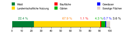
Area distribution
The total area of 27.7 km² is used as follows:
Community structure
The municipality includes the following 17 localities (population in brackets as of January 1, 2020):
- Aist (128) including Giemböcksiedlung and Satzingersiedlung
- Burbach (70)
- Gmeinerhof (59)
- Greising (49) ( Greisinghof )
- Greisingberg (80)
- Grünbichl (581)
- Halmenberg (78)
- Kranzlgarten (98)
- Kriechmayrdorf (78)
- Meitschenhof (106) including Zwieslmayr settlement
- Netzberg (77) with hermit
- Pregarten (3103)
- Pregartsdorf (383) including Hainberg, Pregartsdorf-Scattered Houses and Wiesinger settlement
- Reichenstein (16)
- Selker (113)
- Silberbach (460)
- Worgersdorf (65)
The community consists of the cadastral communities Pregarten, Pregartsdorf and Selker.
history
Early history and the Middle Ages
Neolithic finds point to the early settlement of today's municipal area. The name "Pregarten" ( → see below ) suggests Slavic settlement activity. As part of the colonization of the area by monks from Sankt Florian, starting from the Wartberg near Pregarten, the core settlement around today's town square, which is first mentioned in a document around 1230, is likely to have arisen. Pregarten had market rights as early as the 13th century . Both the Sankt Florian monastery and the Reichenstein estate owned properties in the former village area . The residents lived next to agriculture v. a. from the weaving trade. In 1422 Pregarten was cremated when the Hussite Taborites invaded, and in 1424 and 1443 the place was badly affected in the course of armed conflicts.
Until 1800
Protestantism was very popular in Pregarten in the 16th century . In 1528 the majority of the population was Lutheran, and Protestant preachers preached in St. Anne's Chapel . In 1590, the Wartberg pastor Urban Dräer , who had converted to Protestantism, was given refuge in Pregarten. The Catholic pastor complained about 1650: I was in charge of the parish at an unhappy time. In the sermon there were only barely 20 or 30 people left . In 1611, a marauding mercenary army of 1,500 men quartered in the village under the Walloon Colonel Ramee for refreshment purposes , which put an enormous strain on the local supply situation. In 1626, during the Upper Austrian Peasants' War , the village was attacked, shot at and burned down by a 5000-strong peasant army under Christoph Zeller . From 1632 in the area between the parishes of Pregarten, Gallneukirchen and Luftenberg, a Luftenberg preacher close to the Reformation , the colorful charismatic Martin Aichinger (commonly known as Laimbauer ) , won numerous followers . With his appendix, consisting of a few hundred mainly young people, Laimbauer, who, according to him, claimed to have been in heaven himself after 1635, crossed the Pregartner area several times until he was arrested on the Frankenberg near Langenstein in 1636 after a great bloodshed at the behest of the governor Year was executed on the main square in Linz. As part of the Counter Reformation , the population became predominantly Catholic again. 1644 Pregarten came to the rule of Freistadt at home . At that time there were 66 fireplaces in the market. Greisingberg Castle was built on the Waldaist in the 17th century . In 1784 Pregarten got its own parish .
Until the interwar period
During the Napoleonic Wars , the market suffered badly from billeting and looting by French troops. The place went uphill especially in the second half of the 19th century. With the municipal law of March 17, 1849, the manors in today's municipal area were dissolved and the three municipalities of Pregarten, Pregartsdorf and Selker were created. The first community assembly met on July 17, 1850, the first mayor was Josef Meisl . At that time, every homeowner in the village was still allowed to keep a maximum of twelve sheep.
But the modern age slowly arrived: in 1849 the place got a post office, in 1852 the first streetlights were purchased, in 1853 the district court was settled in Pregarten and in the course of the railway construction of the line Linz - Budweis (see: Summerauer Bahn ) Pregarten got one own train station. In 1868 the place came to the district of Perg, before the allocation to the district of Freistadt followed in 1903. In 1872 the first steam train came to Pregarten. Around 1900 there were 127 houses in the market. During the First World War , the population was affected by a food shortage. The bells of the new parish church, completed in 1897, were melted down for war purposes.
In the First World War, 75 Pregartners died and 17 were reported missing. A separate supply house (house no. 22) was maintained for impoverished citizens, which was replaced by an even larger poor house in 1930 , during the crisis-ridden interwar period .
At the time of National Socialism
Even before Austria was annexed to the German Reich in 1938, there were propaganda campaigns by members of the banned NSDAP in the Pregartner area . On June 24, 1934, a so-called swastika fire was lit in Hagenberg, which led to a forest fire. After the July coup was suppressed in Austria in the same year, the Pregarten police station uncovered an illegal local group of the Hitler Youth . Two days before the Anschluss , the Pregarten National Socialists held a parade through the town. The referendum in Austria carried out by the NSDAP on April 10, 1938, brought a clear result: the voter turnout was 100%, all votes were “Yes” (votes: Pregarten 839, Pregartsdorf 359, Selker 344). With the connection, the market square, which had only been called Dollfussplatz for a few years , was given the name Adolf-Hitler-Platz , which had only lasted a few years longer , and where the leaders' speeches were now broadcast via loudspeakers. In the same year, on July 1, 1938, Pregarten was incorporated into the communities of Pregartsdorf, Selker, Hagenberg , Wartberg and Untergaisbach, which meant that the new large community now had 4,853 inhabitants.
The work situation improved after the connection, in particular due to the expansion of the Königswiesener Bundesstrasse and the new jobs in the Hermann Göring works in Linz. 220 community citizens were members of the NSDAP, the mayor of that time was Ferdinand Fröhlich. In 1944, American planes dropped bombs several times over Pregarten on their return flight from Linz to the northeast, causing death and property damage. Numerous refugees from the east were pushing through the town at this time, the elementary school was closed and a communal kitchen was set up in it, which in February 1945 had to feed up to 1,000 people a day. On May 3, 1945, Soviet soldiers marched through Pregarten for the first time, two days later Mayor Fröhlich handed over the place at the station, which was flagged with white flags, to the Americans. NSDAP local group leaders Sandhöfer and Fröhlich took their own lives. Pregarten had 112 dead and 81 missing in the course of the Second World War .
Nazi persecution and crimes
Pregarten's only Jewish woman, Sarah Epstein, who worked in the pharmacy, is said to have left Pregarten in 1938. From 1940 onwards, Polish forced laborers were used in the Pregartner Farms. In this context, abuse has also been reported. In 1941 the Pregartner Franz Niedermayer (74) and Marie Pfandstätter (26) were murdered as part of the T4 campaign . At the beginning of February 1945, at least five prisoners who had fled the Mauthausen concentration camp were shot dead in the course of the so-called Mühlviertel hare hunt: Two were hiding in a barn in Meitschenhof and were shot by two Volkssturm men near Pregartner train station in the presence of SS members. The shooters were later sentenced to prison terms. Two other prisoners were handed over by the SS to two 15- to 16-year-old Hitler Youths in Steinbichl and shot by them as well. Two other inmates were found hanged near the war mill. The pastor of Pregarten noted the events of those days in his diary: "For sheer cowardice there is no mercy". The director Andreas Gruber used this quote for the title of his film of the same name about the so-called Mühlviertel hare hunt. On April 28, 1945, the regime-critical chimney sweep Johann Hanausek, who had already been arrested in 1939 for statements hostile to the state and the party, was arrested by members of the SS by order of Mayor Fröhlich and presumably murdered. In April and early May 1945, a military court that had been relocated from Vienna was housed in the Pregartner rectory. In the short time leading up to the end of the war, at least 500 deserters were sentenced to death here . Most of them were probably also executed in the Pregarten area, and in 1946 a mass grave with 21 executed people was found in Greising.
Occupation time
Due to the dissolution of the Pregartner community, the population decreased again to 2,437 inhabitants. Selker and Pregartsdorf stayed with Pregarten. The Americans installed the Belgian prisoner of war Peter Gregoire provisionally as mayor, but he only held this post for ten days. Like the entire Mühlviertel, Pregarten came into the Soviet occupation zone. At the beginning of the occupation there were attacks by Allied soldiers on the civilian population: There were multiple rapes and murders. Pregartner police succeeded in 1945 in preventing seven Pregartner civilians from being abducted by Soviet soldiers. There were also difficulties with the Soviet local commanders: two were relieved in 1945 by the Free Town district commandant Major Sacharjan after harassing the local police and local women. The synthetic resin press shop in Pregarten was confiscated as a USIA company during the occupation .
Until the present
From 1955 onwards, new residents settled in Pregarten, initially mainly in Haidfeld and Sandleiten, later mainly in Grünbichl and Silberbach. Pregarten has become particularly attractive for new settlements due to its good transport links in the direction of Linz, especially since the construction of the Mühlkreis Autobahn . Pregarten therefore has a high number of commuters today .
In 1959 a new secondary school (today's elementary school) was built. On June 17, 1972, an earthquake measuring six times caused property damage. In the last few decades, there has been a lot of construction activity in Pregarten: in 1977 the place was connected to the long-distance water supply, in 1978 the new double secondary school was built, in 1984 its own sewage treatment plant was built, a new office building was completed in 1990, the Lagune adventure pool opened in 1994 , the local bypass road was opened in 1999 and in the same year the Bruckmühle cultural center was inaugurated. Two public bus routes operated in the village from 2002 to 2012. Considerable damage was caused by flooding in the Aist valley in 2002 after heavy rainfall . Pregarten was elevated to a municipality on May 31, 2003. Since 2011, the debate about a possible merger of the communities of Pregarten, Hagenberg and Wartberg to form the city of Aist has caused intense discussions .
Historical views
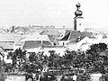
Town view from the south 1876
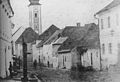
Tragweiner Strasse before 1888

The Marian Column in the year it was built in 1904

Pregartner Ortsplatz 1880


Culture and sights

Numerous artists live in Pregarten, there are several cultural associations, including the cultural group CART , the Pregarten music association , the Comedia drama group and two choirs. Since the opening of the Kulturhaus Bruckmühle , popular theater, music and literature performances have taken place regularly in Pregarten.
Attractions
- Neo-Gothic parish church of St. Anna
- Bruckmühle cultural center
- Reichenstein Castle ruins
- Feldaisttal protected landscape area (hiking trail)
- Neuaist Castle
City parish church of St. Anna
.jpg)

The neo-Gothic parish church of Pregarten was built by master builder Otto Schirmer , presumably on the initiative of Pregarten pastor Wenzel Froschauer .
The construction of the church began in 1893 after the old St. Anne's Church on the market square had become too small. The building, referred to in contemporary sources as a granite cyclopean structure in the early Gothic style , was built from exposed rubble stones and provided with a simple ribbed vault. The tower cross could be attached after just one year of construction. The parish church was inaugurated on August 28, 1897. Their patron saint is St. Anna , whose statue is in the upper part of the high altar. The figure on the left of the tabernacle represents St. Joachim (= husband of Anna), and the figure on the right is St. John the Baptist .
The left side altar shows the Virgin Mary and the right one shows St. Joseph . White marble from Carrara in Italy was used for the stone altars, which were otherwise rare in the 19th and 20th centuries . The altars and statues were made in Innsbruck. Walls and pillars are made of granite . The old church on the market square was demolished in 1903 and a Marian column was erected on the site of the old church, which still characterizes the town square today.
The church is 40 m long and 21 m wide. The tower on the west side is 56 m high. In the cross ball there are documents and coins from the time of construction. The bells were cast in the St. Florian bell foundry , the organ comes from a master organ builder from Ottensheim (Breinbauer organ ). The wooden cross above the people's altar comes from the earlier St. Anne's Church and establishes a tradition from the old to the new church.
Bruckmühle cultural center

The former mill on the bridge over the Feldaist in the valley between the community center and today's train station was mentioned in a document as early as the 13th century. Early 20th century the building complex was converted into a factory ( Upper Austria earthenware factory ). In 1990 the site was acquired by the then market town of Pregarten and expanded into a cultural center according to plans by the architects Peter and Gabriele Riepl , which opened in 1999. The historical building fabric was largely preserved and supplemented with additions. The most noticeable new construction of the facility is the stage building, the so-called boulder , an uneven circular building modeled on stone boulders , which offers space for 480 spectators. The Kulturhaus Bruckmühle has been a venue for conferences and various cultural events ever since. The building also houses the Pregarten State Music School, the Pregarten Music Association and a restaurant. The management and the supervisory board of the Bruckmühle are appointed by the municipality, which is also the sole owner. Between 2004 and 2007 the cultural center had around 70,000 visitors.
Marian column and calvary

Today's town square is dominated by an approximately five meter high Marian column on an oval of green space. It consists of a base, a supporting granite column and a south-facing figure depicting the Virgin Mary . The Marian column was built in 1904 on the site of the old St. Anne's Church that had been demolished a year earlier. The reason for the erection is given on the plaque attached to the base of the 50th anniversary of the dogmatization of the Immaculate Conception in 1854.
Access to the Kalvarienberg is located on Gutauer Straße near the arch of the bridge over the railway tracks. A way of the cross begins here, which leads to the Kalvarienberg chapel, which is situated over a slope to the Feldaist valley. The Way of the Cross and the chapel were donated by Michael Bodingbauer from Pregarten from 1858–60 .
Economy and Infrastructure


economy
Linen weaving was the most important branch of the economy for Pregarten for a long time from the 16th century, until the 1860s textile products were woven in the village. At the beginning of the 20th century, the Upper Austrian Steingutfabrik (operating from 1905 to 1926) was the first industrial company to settle in Pregarten in what is now the Bruckmühle. In the valley of the Feldaist, which runs through the village, there are still several mill buildings. In 1998 there were around 200 companies in Pregarten, of which 83 were commercial, 66 commercial, 30 tourism / leisure and 6 industrial companies. In 1999 there were still 133 agricultural and forestry holdings, 72 of which were full-time farms.
City finances
In 2014, the municipality's income amounted to 12.98 million euros and its expenditure to 13.15 million euros. The debt level was 7.71 million euros.
traffic
Pregarten is located at a crossroads of old trade routes that in the past connected the Alpine foothills with Bohemia and Linz with the Waldviertel. Today's streets Königswiesener Straße B 124, Mauthausener Straße B 123 and Hagenberger Straße L 580 follow the course of the old trade routes. The Königswiesener Straße crosses the city from west to east, since the construction of the Pregartner bypass (1999) it has passed south of the town center. While Mauthausener Strasse begins in Pregarten and leads south, Hagenberger Strasse leads north from the Zainze district via Hagenberg to Mühlviertler Strasse B 310 near Götschka (Neumarkt municipality). Gutauer Straße , which connects the town with the neighboring communities of Gutau and Kefermarkt , flows into the town square . The closest motorway junction to the Mühlkreis Autobahn A 7 is five kilometers away in the municipality of Unterweitersdorf , so the state capital Linz can be reached by car in around 15 minutes.
The Pregarten train station of the Summerauer Bahn has existed since 1873, about half a kilometer from the center of Pregarten . The journey to the main train station in the state capital Linz takes between 33 and 48 minutes, depending on the train (as of 2011).
Public facilities
Pregarten is the seat of a district court and a police station . A regional road maintenance department is responsible for the former federal roads as well as the state and district roads. The Pregarten senior citizen home with 77 beds is also located in the center of the village .
The Pregarten volunteer fire brigade , founded in 1875, provides fire protection and general help in the municipality .
sport and health

The three largest sports clubs are ASKÖ Pregarten, founded in 1922, and UNION Pregarten, founded in 1958, with their own sports facilities and a wide range of sports, as well as Naturefriends Pregarten with various specialist presentations. Next to the indoor pool, which is housed in the New Middle School building, is the Lagune adventure pool (solar-heated outdoor pool) with a 52 m long water slide and a wild water channel. A hiking trail crosses the municipality in the Feldaisttal , which was declared a landscape protection area in this section in 1986. The Giemböcksiedlung weekend house development , which is located south of Pregarten on the Feldaist, brings additional sports enthusiasts .
Health care is provided by six resident doctors, one of the five public pharmacies in the Freistadt district is in Pregarten. The closest hospitals are in Freistadt or Linz.
population
Development and structure

After a total of 1795 inhabitants were given for the year 1846, in 1869 there were 2,012 people living in the municipality. The number of inhabitants rose steadily, especially from 1951. Pregarten became the second largest municipality in terms of population in the Freistadt district. In 1991 the municipality had 4,199 inhabitants at the census , in 2001 already 4,815, which corresponds to an increase of 14.7%. On January 1st, 2008 the community had 4,901 inhabitants, the highest level in its history. The population increase in Pregarten over the past few years is almost entirely due to immigration: while the death-birth-difference in 2005 only showed an increase of 1 person, 77 people moved in the same year. Of the 2,335 people in employment (2001), 1,569 people commute to work in other communities every day. Between 1993 and 2002, 141 new residential units were built in Pregarten.
In the 2001 census, the proportion of residents who were 60 years of age and older was 17.3%; 19% were under 15 years old. The proportion of the female population was 50.3%.
Of the 3,900 Pregarten residents who were over 15 years old in 2001, 4% had graduated from a university , technical college or academy . Another 9.5% had completed the Matura , 49% had completed an apprenticeship or a vocational middle school and 37.5% of all Pregarteners had compulsory school as the highest qualification.
Origin and language
The German dialect, which is generally spoken in the Pregarten area and throughout Upper Austria, is Middle Bavarian . In 2001, 97.3% of Pregarteners stated German as a colloquial language. Another 0.5% spoke mainly Croatian , 0.5% Bosnian , the rest stated other colloquial languages.
The share of Pregarteners with foreign citizenship was 2.3% in 2001, well below the average in Upper Austria. 1% of the Pregartner population had the citizenship of Bosnia-Herzegovina , 0.3% that of Germany and 1% were other citizens. In 2001, around 3.6% of Pregarteners were born in a country other than Austria.
91% of the population are Roman Catholic.
politics
Since 1945 the Pregartner municipal council has received a majority from the ÖVP . Between 2003 and 2009 the SPÖ held the majority in the municipal council. In the municipal council elections in 2009, the ÖVP again received a majority. Directly elected and nominated by the ÖVP mayor has been Anton Scheuwimmer since 1991 , 1st Vice Mayor is Friedrich Robeischl of the ÖVP and 2nd Vice Mayor is Alexander Skrzipek of the SPÖ.
The Mayors of Pregarten :

Data from the homepage of the Province of Upper Austria
Municipal council election 2015
The 2015 municipal council election with a turnout of 84.4% produced the following result:
| Party / political grouping | voting share |
Verän- alteration |
Seats on the local council |
Verän- alteration |
|---|---|---|---|---|
| ÖVP | 52.7% | -4.0% | 18th | −1 |
| SPÖ | 28.3% | -6.9% | 11 | -2 |
| FPÖ | 10.9% | + 10.9% | 3 | +3 |
| GREEN | 8.1% | + 0.0% | 2 | +0 |
National Council election 2019
Election results for the National Council election (2019)
| Political party | be right | percent | Change |
|---|---|---|---|
| SPÖ | 733 | 24.79 | −6.86% |
| ÖVP | 1107 | 37.44 | +5.92% |
| FPÖ | 522 | 17.65 | −7.02% |
| GREEN | 357 | 12.07 | + 9.24% |
| NEOS | 181 | 6.12 | +1.60% |
| KPÖ | 12 | 0.41 | −0.32% |
| NOW | 33 | 1.12 | −1.68% |
| WANDL | 3 | 0.10 | |
| SLP | 9 | 0.30 | + 0.3% |
Judicial district
The judicial district of Pregarten , which included the municipalities of Bad Zell , Gutau , Hagenberg , Königswiesen , Pierbach , Pregarten, Schönau , Tragwein , Unterweitersdorf and Wartberg , was dissolved on January 1, 2014.
Place names
| year | Document designation (selection) |
|---|---|
| 1230 | Pregarten |
| 1356 | the marches Pregarten |
| 1448 | Pregartten |
| 1481 | Pregartenn |
| 1512 | Pregarten |
| 1590 | Pregartn |
| 1671 | Pregarrten |
| 1857 | Embossing types |
The name Pregarten
It is very likely that the name Pregartens derives from Slavic pregrada (fence, enclosure), which originally meant a place protected by a fence or fence. It is also conceivable that the word refers to a founding ritual in which the newly built village area was fenced off (“Pregrada”) in a cultic-ritual manner. An interpretation of the name from Slav. Prĕgrad vor (in front of the castle, outer bailey ) is unlikely to the extent that there are no remains of a fortification in Pregarten. The place name has nothing to do with the Latin prae ("vor": folk etymology sometimes appearing interpretation "Vorgarten"). On October 31, 1938, the spelling of the place name Prägarten (with umlaut) , which has been in use since the 19th century, was changed back to Pregarten (with "e"). As part of this change, the district was Prägartsdorf on Pregartsdorf renamed.
Place names in the municipality
Unless otherwise stated, the following information comes from the presentation by Hohensinner and Wiesinger:
- Pfahnlmühle : First documented in 1449 as Khnuttlmuel . Until the 19th century the mill was called Knüttelmühle ( Knüttel = beater or piston ). After already since the 17th century. different owners belonged to the Pfandl miller family, the mill was finally renamed. * Burbach : First documented in 1691 as Puchenbach , whereby the name does not refer to the beech tree, but to a small tributary of the Waldaist , which was called "Burgbach", especially since there was a small castle on the Greisingberg 500 meters away.
- Pregartsdorf : First documented in 1776 as Pregartdorf . The name is likely to have originated in the Josephine era and refer to the village belonging to Pregarten.
- The name formation of Pregartsfeld (documented in 1591 as Pregarttfeldt ) is to be understood in this sense .
- Hermit settlement : Because of their inaccessible location, the three houses built in 1933 were called hermit houses . * Gmeinerhof : First documented in 1378 as Gmainer . The word means mhd . either what is common in the sense of common ownership (property of a community) or names in the sense of common common ground a co-owner or co-heir.
- Greising : First documented in 1268 as Grusnik . The Slav word "gruša" (= pear) originally meant in this composition possibly a "stream on which pear trees grow". The Slavic - nik was not changed to today's - ing until the 14th century .
- Grünbichl : First documented in 1378 as Greunpuhel , although originally this was only the name of the farm where the settlement was built in the 1970s. Mhd. Pühel (= Bühel ) means a hill . The name basically means a green hill.
- Halmenberg : First documented in 1230 as Haibarenberg . In the first part of the joined name with -berg , the personal name is ahd . Hagabëro suspects.
- Kranzlgarten : The derivation of the name from wreath and garden is obvious, a clear meaning cannot be inferred from the composition.
- Meitschenhof : First documented in the 13th century. as Moutshenauer . A derivation from mhd. Mütsche (= white bread, fine baker's bread ) or from a Slavic personal name that begins with Muč- or Myč- is assumed .
- Moser-Siedlung , Satzinger-Siedlung , Wiesinger-Siedlung , Zwieslmayr-Siedlung : The names of these settlements , which were built in the 1960s and 1970s, all refer to the names of the former landowners on whose grounds they were built.
- Netzberg : First documented in 1380 as Eczperg . The name is derived from mhd. Etze (= pasture ), meaning a mountain that was used as a pasture.
- Selker : First documented in 1580 as Selgger . The name is derived from the ahd. Personal name Sëlpkêr .
- Silberbach : In the name with -bach, silver refers to the sulfur pebbles that can be found here, shining in the sunlight. An inlet to the Aist ( Reisingbach ) is also known as the Silberbach .
- Wintermühle : first documented in 1565 as Wintermill . The winter part of the name could refer to the north-facing (cold) location of the mill on the Feldaist with little sunshine.
- Wögersdorf : First documented in 1230 as Werganstorf . The added name with -dorf contains the ahd. Personal name Wer (i) gant .
coat of arms

The municipal coat of arms is humiliated divided by silver and green. Above are three red, juxtaposed spheres, each equipped with a cross that ends in an arrowhead. Only a green area can be seen below. The meaning is unclear. The representation of the ball with the cross is similar to the symbol used in ancient chemistry for iron saffron. For the relationships between the regions north of the Danube with those to the south, in addition to the salt from the Kammergut , especially the Innerberger Eisen gained importance in the context of the publishing system : the road from Mauthausen via Pregarten to Freistadt developed into an important south-north Trade route. However, there is no evidence of late medieval iron processing in Pregarten. Another interpretation is seen in the three symbols looms. Pregarten was an important weaving place, the local masters were allowed to operate a maximum of three looms each. The community colors are green-white-red.
The municipal coat of arms and the municipal colors were awarded on July 8, 1974. The first use of the coat of arms is documented much earlier, namely in 1555. The seal at that time had the inscription S + DES. MARKET. Z. PREGARTN .
On September 29, 2009, the representation of the coat of arms was slightly changed by resolution of the municipal council. The new layout comes from the Pregartner designer Gerold Zeidler.
Personalities
- Heribert Apfalter (1925–1987), General Director of VOEST-Alpine AG
- Gottfried Bachl (1932–2020), theologian and university professor
- Adolf Drobny (1938–1994), goldsmith and artist, owner of the rock castle
- Herbert Friedl (1943–2018), painter and graphic artist
- Eduard Kriechbaum (1887–1958), doctor and folklorist
- Father Alfred Loschek SJ (1901–1985), Jesuit, educator and former rector of the Kollegium Aloisianum , Freinberg / Linz
literature
- Kurt Klein (edit.): Historical local dictionary . Statistical documentation on population and settlement history. Ed .: Vienna Institute of Demography [VID] d. Austrian Academy of Sciences . Upper Austria Part 1 ( online document , explanations . Suppl . ; both PDF - oD [updated]).
- Karl Hohensinner, Peter Wiesinger: The place names of the political districts Perg and Freistadt . Place name book of the state of Upper Austria. Volume 11. Vienna 2003.
- Josef Mahr: History of the Pregarten market and the surrounding area. Wels 1893 (new edition 2005).
- Market municipality Pregarten (Ed.): Ortschronik Pregarten. 5 volumes, Pregarten 2000.
- Edmund Merl: Occupation in the Mühlviertel. Based on the development in the political district of Freistadt. Linz 1980.
- Franz Stein Maßl: The swastika in the hill country. National Socialism, Resistance and Persecution in the Freistadt District 1938–1945. Edition History of Homeland 1988.
- Helmut Treu: The history of the market town of Pregarten (short version). Pregarten 1994.
Web links
- Bruckmühle cultural center
- Pregarten parish
- Tourism Pregarten
- Entry on Pregarten in the Austria Forum (in the AEIOU Austria Lexicon )
- Map in the Digital Upper Austrian Room Information System ( DORIS )
- Further information about the municipality of Pregarten can be found on the geographic information system of the federal state of Upper Austria .
- Official website of the municipality of Pregarten
- State of Upper Austria - community information
- 40614 - Pregarten. Community data, Statistics Austria .
- Literature on Pregarten in the forum OoeGeschichte.at
Individual evidence
- ^ DORIS: Pregarten , accessed on September 11, 2008
- ↑ Statistics Austria: Population on January 1st, 2020 by locality (area status on January 1st, 2020) , ( CSV )
- ^ Helmut Treu, History of the market town of Pregarten, p. 6.
- ↑ See Richard Kartusch, Ortschronik Volume 5, p. 56.
- ↑ Alois Scheuwimmer, Ortschronik Volume 5, pp. 29–41.
- ↑ Quoted in: Richard Kartusch, Ortschronik Volume 5, p. 54.
- ↑ The above information from: Alois Scheuwimmer, Ortschronik Volume 5, pp. 45–53.
- ↑ Reinhilde Haas, Ortschronik Volume 5, p. 152.
- ^ Helmut Treu, History of the market town of Pregarten, p. 10.
- ↑ Erwin Zeinhofer, Ortschronik Volume 5, p. 131.
- ↑ Richard Kartusch, Ortschronik Volume 5, p. 60.
- ^ Josef Mahr, History of the Pregarten Market, pp. 168–170.
- ↑ Alois Scheuwimmer, Ortschronik Volume 5, p. 145.
- ^ Helmut Treu, History of the market town of Pregarten, pp. 10-12
- ↑ Hedwig & Karl Weiß, Ortschronik Volume 5, p. 78.
- ^ History of the Hagenberg Voluntary Fire Brigade ( Memento from February 14, 2011 in the Internet Archive )
- ↑ Above information from: Franz Stein Maßl: swastika in the hill country. P. 286f.
- ^ Franz Stein Maßl: Swastika in the hill country. P. 288.
- ^ Franz Buchberger: Ortschronik. Volume 5, p. 117.
- ↑ Above information from: Hedwig Weiß, Fritz Fellner: Ortschronik. Volume 5, pp. 79-113.
- ^ Franz Stein Maßl: Swastika in the hill country. P. 290.
- ^ Franz Stein Maßl: Swastika in the hill country. P. 299f.
- ^ Franz Stein Maßl: Swastika in the hill country. P. 293f.
- ^ Franz Stein Maßl: Swastika in the hill country. Pp. 304-309.
- ↑ Guest commentary by Andreas Gruber in the daily newspaper Die Presse on the 60th anniversary of the liberation of the camp in 2005.
- ↑ Detailed documentation on this: Franz Stein Maßl: Hakenkreuz im Hügelland. Pp. 295-299.
- ^ Edmund Merl: Occupation in the Mühlviertel. P. 17f.
- ↑ Edmund Merl, Period of Occupation in the Mühlviertel, p. 59.
- ↑ In addition: Fritz Fellner, Ortschronik Volume 5, p. 111ff.
- ↑ Examples: Edmund Merl, Occupation Time in the Mühlviertel, pp. 157, 169.
- ↑ Edmund Merl, Occupation Time in the Mühlviertel, pp. 148–151.
- ↑ Edmund Merl, Time of Occupation in the Mühlviertel, p. 231.
- ↑ See Ortschronik Volume 1, pp. 20–74.
- ↑ Ortschronik Volume 3, pp. 14–88.
- ↑ Information from: www.gemeindefinanzen.at
- ↑ Fire Brigade City of Pregarten: Home page (accessed on May 13, 2009)
- ↑ See the websites of the sports clubs.
- ^ Ordinance of the Province of Upper Austria on the Feldaisttal landscape protection area
- ^ Directory of doctors: Pregarten
- ↑ 40614 - Pregarten. Community data, Statistics Austria . Population and components of population development (download as pdf) as well as Pregarten chronicle
- ↑ a b 2001 population census: Demographic data (download as pdf; 10 kB)
- ↑ 2001 census: resident population (download as pdf; 10 kB)
- ↑ The mayors of the communities Selker and Pregartsdorf, which were independent between 1850 and 1938, are not included here. A full list can be found here
- ^ Pregarten election results 2008-2019. Stadtamt Pregarten, May 27, 2019, accessed on September 14, 2019 .
- ↑ National Council election results 2019 Pregarten. Stadtamt Pregarten, September 29, 2019, accessed on October 5, 2019 .
- ↑ Hohensinner and Wiesinger, Place Names, pp. 120f.
- ↑ Hohensinner and Wiesinger, Place Names, p. 121.
- ↑ Franz Stein Maßl, Hakenkreuz im Hügelland, p. 289.
- ↑ Hohensinner and Wiesinger, Place Names, pp. 120–126.
- ^ Richard Kartusch, Ortschronik Volume 5, p. 56.
- ^ Province of Upper Austria, regional history: coat of arms of the municipality of Pregarten (accessed on October 29, 2008)

Bad Zell | Free City | Grünbach | Gutau | Hagenberg im Mühlkreis | Hirschbach im Mühlkreis | Kaltenberg | Kefermarkt | Königswiesen | Lasberg | Leopoldschlag | Liebenau | Neumarkt im Mühlkreis | Pierbach | Pregarten | Rainbach im Mühlkreis | Sandl | St. Leonhard near Freistadt | St. Oswald near Freistadt | Schönau im Mühlkreis | Tragwein | Unterweißbach | Unterweitersdorf | Waldburg | Wartberg ob der Aist | Weitersfelden | Windhaag near Freistadt
Bad Leonfelden | Free City | Gallneukirchen | Grein | Perg | Pregarten | Rohrbach Mountain | Steyregg