
Ottensheim
|
market community Ottensheim
|
||
|---|---|---|
| coat of arms | Austria map | |
 |
|
|
| Basic data | ||
| Country: | Austria | |
| State : | Upper Austria | |
| Political District : | Urfahr environment | |
| License plate : | UU | |
| Surface: | 11.73 km² | |
| Coordinates : | 48 ° 20 ' N , 14 ° 11' E | |
| Height : | 270 m above sea level A. | |
| Residents : | 4,738 (January 1, 2020) | |
| Population density : | 404 inhabitants per km² | |
| Postal code : | 4100 | |
| Area code : | 07234 | |
| Community code : | 4 16 17 | |
| NUTS region | AT312 | |
| Address of the municipal administration: |
Marktplatz 9 4100 Ottensheim |
|
| Website: | ||
| politics | ||
| Mayor : | Franz Füreder ( ÖVP ) | |
|
Municipal Council : (2015) (31 members) |
||
| Location of Ottensheim in the Urfahr-Umgebung district | ||
  |
||
 View from Niederottensheim in northwest direction to the historic market center of Ottensheim |
||
| Source: Municipal data from Statistics Austria | ||

Ottensheim is a market town in Upper Austria in the Urfahr-Umgebung district in the upper Mühlviertel with 4738 inhabitants (as of January 1, 2020). The community is located in the judicial district of Urfahr .
The community, once an important trading hub on the Danube, is the third oldest market in Upper Austria and has a historic market center with buildings from the 16th century. In the present, Ottensheim has developed into a popular place to live for families due to its distinctive leisure and recreation areas and its proximity to Linz , combined with strong population growth since the 1990s.
geography
The place Ottensheim is at an altitude of 270 m above sea level. A. in the upper Mühlviertel on the Danube , opposite is the Cistercian monastery of Wilhering . The highest point of the community is the Dürnberg with a height of 549 m above sea level. A.

The extension of the municipality is 3.9 km from north to south and 5.8 km from west to east. The total area is 11.7 km².
From the point where the Rodl joins the Danube , the community area extends upriver for around 2 km across the entire width of the Danube and parts south of the river bank.
The Danube power plant Ottensheim-Wilhering is located entirely in the municipality of Ottensheim. A small part of the oxbow lake that was created during the construction of the Danube power plant and which runs parallel to the Danube is already located in the Goldwörther municipality. From the confluence of the Pesenbach into the old arm of the Danube, the Ottensheim-Goldwörth municipal boundary runs towards a fictional point in the middle of the Danube, around 200 m upstream behind the Danube power plant. The same applies to the Ottensheim-Wilhering municipal boundary.
The municipality extends south of the Danube until shortly before the Innbach Bridge. A few meters south of the road crossing this bridge, the border begins to run in a dead straight line to the aforementioned fictional point in the Danube. The less than 1 km² large Ottensheim municipal area south of the Danube, which extends in the west to behind the power plant, reaches an average of 200 to 300 m in the south and leaves the mainland in the east at about the level of the opposite Rodl estuary, is called Marktau and has no residents.
Neighboring communities
| Walding | Gramastetten | |
| Goldwörth |
.svg)
|
Puchenau |
| alcove | Wilhering |
Community structure
The municipality includes the following localities (population in brackets as of January 1, 2020):
- Dürnberg (697)
- Höflein (121)
- Niederottensheim (522)
- Ottensheim (3247)
- Vineyard (151)
The village of Ottensheim itself has the majority of the total population and the other settlements, with the exception of the Achleitnersiedlung bordering on Puchenau, border almost seamlessly on the district of Ottensheim. Compared to almost all other municipalities in the Mühlviertel, but also elsewhere, whose municipal area is usually much larger and also has some districts and widely scattered settlements, Ottensheim is a rare exception due to the concentration of the majority of the residents in a closed settlement area.

Area distribution

history
| Population development |
|
|---|---|
| date | Residents |
| 1869 | 1,868 |
| 1880 | 1,750 |
| 1890 | 1,838 |
| 1900 | 1,987 |
| 1910 | 2,053 |
| 1923 | 1.961 |
| 1934 | 1,949 |
| 1939 | 2.117 |
| 1951 | 2,455 |
| 1961 | 2,871 |
| 1971 | 3,145 |
| 1981 | 3,579 |
| 1991 | 3,796 |
| 2001 | 4,312 |
| 2011 | 4,503 |
| 2018 | 4,721 |
etymology
The name Ottensheim can be derived from the Old High German prefix “Oten-” or “Oto-”, but also from the personal names “Otuni” or “Otini”. Hence the name of the knight Otini, who once had a castle built here. All of these prefixes can be traced back to the common ancestral form from the old Germanic: "AUDA". This meant "wealth", "treasure", "possession".
Early days
Archaeological finds from the Neolithic period around 4000 BC As well as a burial ground from the Hallstatt period , which dates back to 700 BC. Is dated, indicate first settlement activity. Around 2000 years ago, there was a Roman watchtower on a hill directly on the Danube .
Middle Ages and Habsburg times
At the site of the Roman fortification, Knight Otini - from which Ottensheim could get its name - had a castle built. Oteneshaim was first mentioned in a document in 1148. From 1227 the Ottensheim castle was owned by the Babenbergs . 1228 were by the Austrian Duke Leopold VI. Ottensheim's market rights confirmed. At this point in time only Linz (since 1210) and Enns (since 1212) had market rights in Upper Austria . Ottensheim was assigned to the Principality of Austria ob der Enns from 1490 . In the Middle Ages Ottensheim had a protective wall, which was accompanied by a moat on both sides. Today these are the streets “Innerer Graben” and “Outer Graben”. Three gates - Schmiedtor, Linzertor and Wassertor - granted access to the core of the community.
In 1527 King Ferdinand I gave the Ottensheim castle and market to his chancellor Niklas Rabenhaupt von Suche . He had the castle converted into a palace and gave Ottensheim its current market coat of arms.
Ottensheim has existed as a political municipality since 1848. At that time it had the cadastral municipalities Niederottensheim, Oberottensheim and Puchenau. The first municipal council was constituted that year.
.png&filetimestamp=20100903023030&)
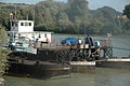
The first wire rope bridge was opened in 1871 - a roller ferry that is driven by currents and secured by wire ropes. Until then, the Förgen had the task of professionally crossing the Danube. After just eight years, however, the cable bridge was destroyed in an ice rush and flood. The second wire rope bridge was opened in 1882 and was only replaced in 1964 by the (roller) ferry that is still in operation today.
The place was occupied several times during the Napoleonic Wars , but has since returned to Upper Austria. Puchenau , which had previously belonged to Ottensheim, was raised to a separate municipality by a state resolution . At lunchtime on June 7, 1899, a fire destroyed over 130 of the 160 houses and parts of the church that had previously had an onion dome . 9 people were killed. Only later did a poor house inhabitant admit to having started the fire.
First and Second Republic
Towards the end of the Second World War , the castle served as accommodation for refugees. After that it was occupied by the Soviet Union . The castle has been privately owned by various families since 1955.
politics
After the 2015 elections, the municipal council is divided as follows: ÖVP 12 mandates - ProO 12 mandates - SPÖ 4 mandates - FPÖ 3 mandates.
- mayor
- 2003–2015 Ulrike Böker (citizen list pro O.)
- since 2015 Franz Füreder (ÖVP)
- Others
- In the national elections in Austria in 2006 , Ottensheim was the municipality in which the Greens were able to achieve the largest share of votes in Upper Austria with 20.92%.
- As of April 2, 2018, Ottensheim was the municipality with the highest percentage of supporters in Austria for the initiation of the Don't Smoke referendum, which is critical of tobacco smoke : 20%.
coat of arms
Blazon : Divided by blue and black; in the middle a golden round tower with two windows and two loopholes and a red conical roof with golden pommel, the round arched gate with golden portcullis, accompanied by two similar, deposed, six-ended stag poles . On both sides of the tower in the black field a golden, continuous, square wall, behind it a row of houses showing gable and front sides, red roofed and decorated with golden weather flags. The community colors are blue-black.
Economy and Infrastructure

In the Census of Statistics Austria 15 with date May 2001 were (including 1 with more than 100 employees) counted 242 workplaces with a total of 1,394 employees. Compared to 1991, this means an increase of 82 workplaces to the extent of 312 jobs, which is mainly due to the construction of a shopping center at the intersection of the two main traffic axes B 127 and B 131 .
Among other things, the publishing house Edition Thanhäuser is located in Ottensheim .
For several years there has been a market for food such as fruit, vegetables and baked goods from the region every Friday afternoon.
Around 45 farms are active in Ottensheim, 20 of them as full-time farmers.
The Danube power plant Ottensheim-Wilhering , which, contrary to its name, is entirely located in the Ottensheim municipality, is the seventh largest run-of- river power plant in Austria.

Ottensheim station
The Ottensheim wire rope bridge


traffic
- Street: Ottensheim is at the junction of the busy Aschacher Strasse (B 131) and Rohrbacher Strasse (B 127), which leads to Linz.
- Train: The Mühlkreisbahn crosses Ottensheim.
- Shipping pier: Ottensheim has had a shipping pier in the Danube Park near the Danube ferry for several years
- Ottensheim wire rope bridge: The wire rope bridge provides a connection across the Danube
Culture and sights


Buildings
- Ottensheim Castle : privately owned
- Parish church: Gothic, construction of today's parish church began in 1467
- Marketplace
- dasparkhotel by Andreas Strauss
- see also: List of listed objects in Ottensheim
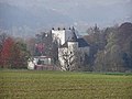
View from Wilhering to Ottensheim Castle
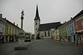
The Ottensheim market square looking north

The Ottensheim market square looking south over the Danube to Wilhering


Theater and cinema

Although Ottensheim does not have a permanent theater building, it does have several facilities and inns suitable for theater events. These are mainly performed by the Theater Tabor , which has already won awards at foreign theater festivals, and the stage in Ottensheim several times a year with new plays.
- Ottensheim film scene: Since 1919, a single-room cinema has also enriched the market town of Ottensheim, the Ottensheim film scene . For decades this was located on Hostauerstrasse in the immediate vicinity of the market square. Since 1985, however, the cinema has been housed in the new building on Bahnhofstrasse, the specialty of which is that most of the seats are arranged next to tables that are also served with food and drinks during the performances.
societies
Ottensheim has an extensive club life with around 60 clubs, in which more than half of the residents are involved. The diversity ranges from the club with the largest number of members by far, the gymnastics and sports club (TSV) Ottensheim, to numerous music and singing clubs thanks to the regional music school in Ottensheim, to the theater club stage Ottensheim - the cultural association ARGE Granit and the youth culture association culture without current settlement ( KomA), which together with the Linz associations Kapu and Stadtwerkstatt (Stwst) also organizes the annual alternative music festival Open Air Ottensheim .
Other associations are: Fotoclub Ottensheim, Kindergarten and Hortverein, Church Choir Ottensheim, Music Association Ottensheim, Pathfinder Ottensheim, Chess Club Ottensheim, String Orchestra Ottensheim, w³.ottensheim.at, Streuobstwiesen Ottensheim, Theater Tabor, CHORnetto, Tonart Chor Ottensheim, Landjugend Ottensheim
freetime and sports

There are extensive sports facilities and green spaces along the Danube:
- In the east of the municipality there are three soccer fields , a tennis center, the Danube Hall - a multi-purpose hall with continuous sauna operation, squash rooms and a large hall - mostly used as a tennis court. To the west of these facilities there is a green strip along the Danube with an avenue and playground.
- The Ottensheim landing stage is also located there on the regatta course, a sidewalk that runs along the Danube.
- A short distance away is the Ottensheim cable bridge - a cable ferry across the Danube that shuttles between Wilhering and Ottensheim solely through the current of the Danube.
- Another green strip then opens up the area at the ferry pier with the toboggan area, a leisure area located between the Rodl and the 1st flood protection dam . The tall trees give shade to the area used for barbecues and parties. A playground, two asphalt curling lanes and two beach volleyball courts provide further activities on the site, on which there is also an El danubio buffet , which exudes South American flair and also offers cultural events. In winter, both the 1st and 2nd dam, which is no longer part of the toboggan area, are used for sledding and the like.
- A little further to the west is the Ottensheim regatta center. This uses the around 2 km long arm of the Danube, which was created by the power plant construction in the 1970s, for rowing and canoeing competitions. The state rowing championships are held there every year, at which the team from the Ottensheim water sports club regularly achieves top ranks. The former world rowing champion Wolfgang Sigl also comes from this community. The 2008 World Rowing Championships and the 2019 World Championships also took place at the Ottensheim regatta center .

Where the oxbow lake joins the Danube and the river is therefore particularly wide, an island of Danube mud was deposited during the floods in 2002 , which the population welcomed as a bathing beach the following summer, although there were and still are hygienic concerns . Nevertheless, during the summer months when the water is low and the weather is good, up to 100 people or more come to use the island, 30 to 40 meters long and 15 to 25 meters wide, depending on the water level, to sunbathe and relax and the Danube for swimming.
Along the Danube or the arm of the Danube located throughout a cycle path, which is part of the Danube cycle path from Passau to Vienna. In addition to numerous bicycle tourists in the summer, who also visit the community's guest gardens at this time of year, the locals also like to go jogging, skating, cycling and the like.
Regular events


Annual fixed points in the community life of Ottensheim are festivals such as the May Festival , Market Festival and the Dürnberg Festival . During the carnival season, several balls and Gschnase take place in different places . Concerts by local music associations, the youth culture association, inns and pubs enrich the community's nightlife almost every week. For years, the 2-day open air at the start of the holiday at the Rodlgelände has made a significant contribution to the local concert spectrum. During the warm season, concerts by guest musicians take place there every few weeks. For large events such as cabaret evenings, trade fairs and concerts, the Donauhalle with up to 1400 seats is the venue. Alternating with Bad Leonfelden and Gallneukirchen , the GUUTE fair, a regional business fair, takes place in Ottensheim every three years.
Every few years, Ottensheim is also one of the venues for the Festival of the Regions and the Danube in Flames cultural event .
In addition to games of the local sports clubs, sporting events also include the international rowing regattas that are held on the oxbow lake of the Danube. International championships such as the Junior Rowing World Championships have already taken place there several times. In 2008 the World Rowing Championships took place there.
The Open Air Ottensheim has also been taking place at the beginning / middle of July since 1993 . The two-day event takes place on the Rodlgelände, a leisure area on the Danube, and also offers camping facilities for several hundred people. The total number of visitors is usually between 2000 and 4000 people (although the festival has become smaller again in recent years), who can experience a little more than 10 bands, some of which come from the region, from the rest of Austria and from various countries around the world. The focus of the festival tends to be on the various, sometimes experimental, varieties of rock music. Well-known hip-hop acts and music groups from other, varied genres are invited to the variation every year.
Personalities
- Josef Breinbauer (1807–1882), organ builder
- Leopold Breinbauer Sr. (1859–1920), organ builder
- Franz Dinghofer (1873–1956), politician
- Leopold Breinbauer jun. (1886–1920), organ builder
- Rudolf Breinbauer (1888–1973), sculptor and boat builder
- Marianne Woitsch (1873–1945), painter
- Helmut Renöckl (* 1943), Roman Catholic theologian
- Ulrike Böker (* 1956), politician
- Christian Thanhäuser (* 1956), artist, illustrator and publisher
- Ferry Öllinger (* 1959), actor (including SOKO Kitzbühel )
- Sophie Rois (* 1961), theater and film actress, singer
- Christoph Campestrini (* 1968), Austrian conductor
- Wolfgang Sigl (* 1972), rower
- Sybille Bammer (* 1980), tennis player
literature
- Walter Steiner: From Ottensheim's Past, Ottensheim 1997 online
- Otto Kampmüller and Christian Thanhäuser (eds.): Ottensheim in der Literatur, Edition Thanhäuser , Ottensheim 1989
Web links
- Community website
- Map in the Digital Upper Austrian Room Information System ( DORIS )
- 41617 - Ottensheim. Community data, Statistics Austria .
Further information about the community of Ottensheim can be found on the geographic information system of the federal state of Upper Austria .
Individual evidence
- ↑ Statistics Austria: Population on January 1st, 2020 by locality (area status on January 1st, 2020) , ( CSV )
- ↑ a b Province of Upper Austria, results of the 2015 elections. Accessed on May 3, 2019 .
- ↑ ORF, Ö1 holiday journal, Easter Monday, April 2, 2018, 1 p.m.
- ^ State of Upper Austria, history and geography, coat of arms. Retrieved May 3, 2019 .
- ↑ w³.ottensheim.at club

.png&filetimestamp=20100903023030)
Alberndorf in the Riedmark | Altenberg near Linz | Bad Leonfelden | Eidenberg | Engerwitzdorf | Feldkirchen an der Donau | Gallneukirchen | Goldwörth | Gramastetten | Haibach im Mühlkreis | Hellmonsödt | Herzogsdorf | Kirchschlag near Linz | Lichtenberg | Oberneukirchen | Ottenschlag in the Mühlkreis | Ottensheim | Puchenau | Reichenau im Mühlkreis | Reichenthal | Schenkenfelden | Sonnberg in the Mühlkreis | St. Gotthard in the Mühlkreis | Steyregg | Vorderweißbach | Walding | Zwettl on the Rodl