
Hellmonsödt
|
market community Hellmonsödt
|
||
|---|---|---|
| coat of arms | Austria map | |
 |
|
|
| Basic data | ||
| Country: | Austria | |
| State : | Upper Austria | |
| Political District : | Urfahr environment | |
| License plate : | UU | |
| Surface: | 18.08 km² | |
| Coordinates : | 48 ° 26 ' N , 14 ° 18' E | |
| Height : | 825 m above sea level A. | |
| Residents : | 2,325 (January 1, 2020) | |
| Population density : | 129 inhabitants per km² | |
| Postal code : | 4202 | |
| Area code : | 0 72 15 | |
| Community code : | 4 16 11 | |
| NUTS region | AT312 | |
| Address of the municipal administration: |
Marktplatz 1 4202 Hellmonsödt |
|
| Website: | ||
| politics | ||
| Mayor : | Jürgen Wiederstein ( ÖVP ) | |
|
Municipal Council : (2015) (25 members) |
||
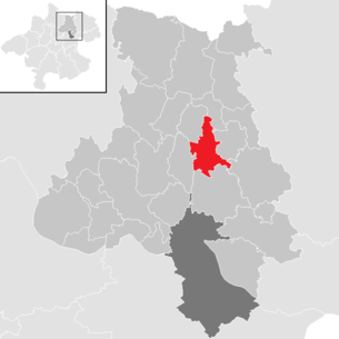
| Location of Hellmonsödt in the Urfahr-Umgebung district | ||
  |
||
 Taken from the observation tower of the Breitenstein in Kirchschlag |
||
| Source: Municipal data from Statistics Austria | ||

Hellmonsödt is a market town in Upper Austria in the Urfahr-Umgebung district in the upper Mühlviertel with 2325 inhabitants (as of January 1, 2020). The community is located in the judicial district of Urfahr .
geography
Hellmonsödt lies at an altitude of 825 m above sea level. A. in the central area of the Urfahr-Umgebung district in the upper Mühlviertel . In terms of the nature conservation spatial structure, the southern municipal area is part of the Central Mühlviertel highlands, while the north of the municipality belongs to the Leonfeldner highlands . The western edge of the municipality also extends into the southern Bohemian Forest foothills , and the Haselgraben in the extreme south-west creates a small proportion of the Danube gorge and side valleys . The extension is 7.8 km from north to south, 5.5 km from west to east, the total area is 18.08 km². Hellmonsödt is thus in the middle of the range of municipalities in the district. With 120 inhabitants per km², Hellmonsödt was in the upper midfield of the municipalities in 2013. In 2001 49 percent of the community area was forested, 45 percent of the area was used for agriculture. In comparison with the federal state of Upper Austria, Hellmonsödt was much more forested (Upper Austria: 38.3 percent and 49.3 percent respectively). The proportion of other uses (construction areas, gardens, bodies of water and others) was 6 percent below the Upper Austrian average of 13.8 percent.
Community structure
The municipality includes the following localities (population in brackets as of January 1, 2020):
- Althellmonsödt (193) including Haselgraben and Im Hölzl
- Auedt (32)
- Eckartsbrunn (173)
- Hellmonsödt (1573) including Glasau
- Oberaigen (82)
- Pelmberg (128) including forest houses
- Weberndorf (44)
- Weignersdorf (100) including the forest settlement
Neighboring communities are Altenberg near Linz in the south, Kirchschlag near Linz in the southwest and west, Sonnberg in the Mühlkreis in the northwest, Reichenau in the Mühlkreis in the north and northeast, Haibach in the Mühlkreis in the east and Alberndorf in the Riedmark in the southeast.
Geology and soils
The landscape of the municipality is part of the granite and gneiss plateau ( Bohemian mass ), which goes back to a very old mountain range, which was formed by the Variscan mountain formation in the Phanerozoic / Paleozoic ( Carboniferous ). After the strong erosion of the former high mountains, during the Alpidic mountain formation in the Neogene the crystalline basement was abolished and subsequently in the Neogene and Quaternary sediments were deposited. The community area rises from Haselgraben to the east, with the highest point in the community area at around 860 meters in the Breitlüsser Forest. The dominant soil type in the municipality is lime-free rock brown earth made of silicate material, with Weinsberg granite and porphyry gneiss predominating. The loamy sandy soils have a high to very high proportion of coarse. In addition, there are lime-free gley soils in trenches and hollows, with relict pseudogley predominating in the leveling areas and pseudogley in the other areas. While the rock brown earth represents medium to low-quality arable land, which causes heavy equipment wear due to the high coarse content, gley soils represent medium-quality arable and grassland that is easy to work or drive on.
Landscape and vegetation
The municipality of Hellmonsödt is divided into three sub-landscapes. In the north there is an intensive agricultural zone with a densely populated settlement area with the Hellmonsödt community center. The sub-area lies in the Leonfeldner highlands, with the western edge sloping down to the Haselgraben and partly belongs to the natural areas of the Central Mühlviertel highlands or Danube gorge and side valleys. Most of the landscape is covered by intensively cultivated grassland, arable land is only to a small extent. In addition, there is a spruce forest in the north-east, which is the southern branch of the Dreiegg Forest. In addition, there are smaller forests in the area of the hilltops and slopes. In the south, the intensive agricultural zone is followed by a hilltop landscape with a closed forest area, which houses the Breitlüss forest. It is a contiguous forest area that is predominantly used for forestry spruce forests. South of the Breitlüsser Wald there is an intensively agriculturally used residual structural landscape, in which there are mainly areas with mixed arable and grassland farming with permanent pasture areas. There are also settlements with a village character and several hamlets.
Waters
The municipal area is drained to the west to the Haselbach and to the east to the Großer Gusen . The Große Haselbach runs from the north-west of the municipality to the south, although the water runs parallel to the western municipal boundary, but mostly a little outside of it. The Haselbach has a continuous accompanying wood and meanders freely and largely close to nature. In addition, with the Schlossbach and the Ramberger Bach in the north of the municipality, there are two feeders to the Großer Gusen, whereby the Schlossbach at or in the Breitlüsser Forest and the Ramberger Bach run free of wood or in the forest at the northeastern municipal boundary. In addition to the Schlossbach, the Baumbach also rises in the Breitlüsser Wald, where the Baumbach flows into the Schlossbach. In the south of the municipal area, the freely meandering Gusenbach flows from north to south-east, which has continuous, but locally only single-row, riparian trees. There is also the Hatbach and the Steinbach. Only a few ponds are standing water in the municipality.
Community structure
The municipality is divided into the cadastral municipality of Hellmonsödt in the north and west of the municipality and the cadastral municipality of Pelmberg in the southeast. KG Hellmonsödt has a size of 1,358.08 hectares, Pelmberg is 447.55 hectares. In the cadastral community of Pelmberg, in the south, at an altitude of 800 meters, is the scattered settlement Pelmberg, which also includes the Rotte Waldhäuseln and the individual farms or houses in the Pelmberg and Rössl Open Air Museum. In 2001, Pelmberg comprised 44 buildings and 14 agricultural and forestry facilities as well as two workplaces. To the east of Pelmberg is the scattered settlement Weignersdorf with the forest settlement, whereby the district in 2001 comprised 27 buildings and nine agricultural and forestry facilities as well as two workplaces.
population
Population structure
In 2014, 2,194 people lived in the community, placing Hellmonsödt in the middle of the range for the district's communities. At the end of 2001 97.1 percent of the population were Austrian citizens (Upper Austria 92.8 percent, Urfahr-Umgebung district 97.9 percent), by the beginning of 2013 the value had fallen slightly to 96.3 percent (Upper Austria 91.1 percent, Rohrbach district 96.9 percent). A total of 80 foreigners were counted in the municipality in 2013, 68 percent of whom came from Europe and more than half from EU countries. A total of 125 people with a foreign country of birth lived in Hellmonsödt in 2013. In 2001, 87.3 percent of the population committed to the Roman Catholic Church (Upper Austria: 88.6 percent), 8.0 percent were without a religion, 1.5 percent were Islamic and 2.1 percent were Protestant.
The average age of the community population in 2001 deviated only slightly from the national average. 20.7 percent of the residents of St. Martin were younger than 15 years (Upper Austria: 18.8 percent), 61.5 percent between 15 and 59 years old (Upper Austria: 61.6 percent). The proportion of residents over 59 years of age was 17.9 percent, below the national average of 20.2 percent. The average age of the population of Hellmonsödt changed as a result, especially in the first two segments. The proportion of people under 15 years of age fell sharply to 14.2 percent on January 1, 2013, while the proportion of people between 15 and 59 years of age increased significantly to 68.8 percent. The proportion of people over 59 years of age fell slightly to 17.0 percent. According to marital status, in 2001 43.8 percent of Hellmonsödt's residents were single, 47.4 percent married, 4.1 percent widowed and 4.8 percent divorced.
Population development
The population of the community of Hellmonsödt rose by 222 percent between 1869 and 2013, which means that the population development was slightly above the development in the federal state of Upper Austria and in the Urfahr-Umgebung district. The population development lagged behind that in the state until the middle of the 20th century, with the population fluctuating between around 950 and 1,100 inhabitants from 1869 onwards. Only in the second half of the 20th century did the population of the municipality gradually increase, with growth rates of between 15 and 26 percent per decade between 1971 and 2001 being recorded. The reasons for the high growth rates in the second half of the 20th century were both a high birth surplus and significant immigration as a result of the location near the state capital Linz. The migration balance has been almost balanced since 2001, but thanks to a surplus of births the municipality was able to easily gain more inhabitants.

history
Originally located in the eastern part of the Duchy of Bavaria , the place has belonged to the Duchy of Austria since the 12th century and to the Principality of Austria ob der Enns since 1490 .
The first documented mentions of the place come from the years 1260 ( Helmigsode ), 1366 ( Helmeisoede ) and 1370 ( Helmansode ), whereby the place name can be traced back to the personal name Helmwig or Helmwicus, which was common in the 13th century .
During the Napoleonic Wars , the place was occupied several times and has since returned to Upper Austria.
After Austria was annexed to the German Reich on March 13, 1938, Upper Austria became the Gau Oberdonau . After 1945 the restoration of Upper Austria took place.
In 1875 the community of Sonnberg in the Mühlkreis was affiliated. Sonnberg has been independent again since 1919. Today Hellmonsödt is a local recreation area of the state capital Linz .
politics
Municipal council
The municipal council as the highest body of the municipality has 25 seats and is elected every six years in the course of Upper Austria-wide municipal council elections. The municipality board consists of seven members, whereby the Austrian People's Party (ÖVP) is represented after the municipal council elections in 2009 with the mayor, the vice mayor and two other members on the municipality board and thus has an absolute majority in this body. The Social Democratic Party of Austria (SPÖ) sends two more members, the Freedom Party of Austria (FPÖ) one member.
The strongest parliamentary group in Hellmonsödt's municipal council has always been the ÖVP, which has always had an absolute majority of votes and seats since 1945. In 1945 and 1979 it was even able to book a two-thirds majority for itself. The ÖVP achieved its best election result in 1945 with 70.7 percent of the vote; in 1973 the ÖVP achieved 53.3 percent, its worst result to date. The second strongest party in Hellmonsödt's municipal council has always been the SPÖ, which achieved its best result to date in 1967 with 45.9 percent. Since the 1980s, the SPÖ had results between 24.8 and 36.3 percent, with the SPÖ recording its worst result in 1997. The Freedom Party ran for elections in 1955, but just as in 1973 they missed a mandate when they ran for the second time. The FPÖ has been consistently represented in the municipal council since 1991, with election results between 9.6 and 19.7 percent. In the last municipal council election in 2009, the ÖVP received 59.0 percent or 15 seats, the SPÖ 27.1 percent or seven seats and the FPÖ received 13.9 percent or three seats.
Result of the election on September 27, 2009: Eligible to vote: 1,753 +170, valid votes: 1,433, turnout: 84.83% +2.27%
| Political party | percent | be right | Mandates | ||
|---|---|---|---|---|---|
| ÖVP | 58.97% | + 4.79% | 845 | 15th | +1 |
| SPÖ | 27.15% | −9.10% | 389 | 7th | −2 |
| FPÖ | 13.89% | + 4.32% | 199 | 3 | +1 |
mayor
The mayor has been determined by direct election since 1997 , with no absolute majority for a candidate in a runoff election . The first direct mayor election was won by Mayor Anton Schwarz (ÖVP) with 60.5 percent against the candidates of the SPÖ and FPÖ in the first ballot. In 2003 and 2009, black prevailed against its two competitors with 55.6 and 67.1 percent respectively.
Mayor since 1850:
| Term of office | Surname | Term of office | Surname |
|---|---|---|---|
| 1850-1875 | Franz Paul Lugmayr | 1945-1946 | Karl Edtstadler |
| 1875-1894 | Josef Hochmair | 1946-1949 | Josef Kaineder |
| 1894-1906 | Michael Penzenleitner | 1949-1961 | Ludwig Egger |
| 1906-1919 | Franz Schwarz | 1961-1973 | Johann Obermüller |
| 1919-1920 | Egid Franzl | 1973-1997 | Hermann Schwarz |
| 1920-1924 | Josef Lugmayr | 1997-2014 | Anton Schwarz |
| 1924-1929 | Karl Ortner | since 2015 | Jürgen Wiederstein |
| 1929-1934 | Johann Schwarzmüller | ||
| 1934-1945 | Johann Radlmüller |
coat of arms
The municipal coat of arms was determined by the municipal council on December 23, 1976, as were the municipal colors (black-yellow-green). The award of the municipal coat of arms and the approval of the municipal colors determined by the municipal council finally took place through a resolution of the Upper Austrian provincial government on January 31, 1977. The blazon of the coat of arms reads: In black over a green three-mountain, a golden piercing helmet. The coat of arms is based on a design by Franz Lehrer from Linz and is based on the oldest known market seal with the inscription S. D. MARKET HELMSED . The coat of arms image is intended to talking point to the place name, said, however, more derived from the early establishment of a "Helmwic in the desolation." The Dreiberg, which did not appear in the original market seal, indicates the geographic location of the community above the Linz Danube basin at the apex of the Haselgraben.
Attractions
- Parish Church Hellmonsödt: The late Gothic church was built on behalf of Johann von Starhemberg. The church has a differently designed ribbed vault in the chancel.
- Pelmberg open-air museum with Mittermayr memorial courtyard : The memorial courtyard, first mentioned in a document in 1325 and established in 1966, gives a lively picture of the historical work and living environment in a Mühlviertel farm.
- Artemons art museum : next to the Angerlehner museum, one of the largest private museums in Upper Austria for contemporary painting a. a. with permanent exhibition of works by Albrecht Dunzendorfers
- Planet path
Personalities
Sons and daughters:
- Johann Ignaz Schiffermüller (1727–1806), theologian and zoologist , important Austrian lepidopterologist
- Peter Hofbauer (1886–1962), farmer and politician
Honorary citizen:
- Albrecht Dunzendorfer (1907–1980), painter
Web links
- 41611 - Hellmonsödt. Community data, Statistics Austria .
- Further information about the community of Hellmonsödt on the geo-information system of the federal state of Upper Austria .
- Map in the Digital Upper Austrian Room Information System ( DORIS )
- Literature on Hellmonsödt in the forum OoeGeschichte.at
Individual evidence
- ↑ a b c d Province of Upper Austria: Mapping of natural areas in Upper Austria. Landscape survey of the municipality of Hellmondsödt. Final report. Kirchdorf an der Krems 2008
- ↑ Statistics Austria: Population on January 1st, 2020 by locality (area status on January 1st, 2020) , ( CSV )
- ↑ Statistics Austria: Upper Austria Directory 2005
- ↑ a b Province of Upper Austria ( Memento of the original from November 29, 2014 in the Internet Archive ) Info: The archive link was inserted automatically and has not yet been checked. Please check the original and archive link according to the instructions and then remove this notice. Population levels in Upper Austria in comparison by citizenship
- ↑ Statistics Austria: Population by religion and federal states 1951 to 2001 (accessed on October 2, 2013)
- ↑ a b c Statistics Austria municipality data from Hellmonsödt
- ↑ a b Province of Upper Austria ( Memento of the original from October 29, 2013 in the Internet Archive ) Info: The archive link was automatically inserted and not yet checked. Please check the original and archive link according to the instructions and then remove this notice. Resident population in Upper Austria compared by age group
- ↑ Karl Hohensinner and Peter Wiesinger : Place Name Book of the Province of Upper Austria 10. The place names of the political district Urfahr-Umgebung (Middle Mühlviertel). Vienna 2006
- ↑ State of Upper Austria ( Memento of the original from May 2, 2014 in the Internet Archive ) Info: The archive link was automatically inserted and not yet checked. Please check the original and archive link according to the instructions and then remove this notice. Local council elections in Hellmonsödt from 1945
- ^ Province of Upper Austria election results in mayoral elections in Hellmonsödt
- ↑ State of Upper Austria Mayor of Hellmonsödt since 1850
- ^ Upper Austria: Hellmonsödt coat of arms
- ↑ outdoor museum Pelmberg Denkmalhof "Mittermayr"
- ^ Artemons Art Museum

Alberndorf in the Riedmark | Altenberg near Linz | Bad Leonfelden | Eidenberg | Engerwitzdorf | Feldkirchen an der Donau | Gallneukirchen | Goldwörth | Gramastetten | Haibach im Mühlkreis | Hellmonsödt | Herzogsdorf | Kirchschlag near Linz | Lichtenberg | Oberneukirchen | Ottenschlag in the Mühlkreis | Ottensheim | Puchenau | Reichenau im Mühlkreis | Reichenthal | Schenkenfelden | Sonnberg in the Mühlkreis | St. Gotthard in the Mühlkreis | Steyregg | Vorderweißbach | Walding | Zwettl on the Rodl