Gramastetten
|
market community Gramastetten
|
||
|---|---|---|
| coat of arms | Austria map | |
|
|
||
| Basic data | ||
| Country: | Austria | |
| State : | Upper Austria | |
| Political District : | Urfahr environment | |
| License plate : | UU | |
| Surface: | 40.23 km² | |
| Coordinates : | 48 ° 23 ' N , 14 ° 11' E | |
| Height : | 545 m above sea level A. | |
| Residents : | 5.114 (January 1, 2020) | |
| Postcodes : | 4201, 4040 | |
| Area code : | 07239 | |
| Community code : | 4 16 09 | |
| NUTS region | AT312 | |
| UN / LOCODE | AT GRT | |
| Address of the municipal administration: |
Marktstrasse 17 4201, 4040 Gramastetten |
|
| Website: | ||
| politics | ||
| Mayor : | Andreas Fazeni ( ÖVP ) | |
|
Municipal Council : (2015) (31 members) |
||
| Location of Gramastetten in the Urfahr-Umgebung district | ||
 Gramastetten |
||
| Source: Municipal data from Statistics Austria | ||
Gramastetten is a market town in Upper Austria in the Urfahr-Umgebung district in the upper Mühlviertel with 5114 inhabitants (as of January 1, 2020). The community is located in the judicial district of Urfahr .
geography
Gramastetten lies at an altitude of 545 m above sea level. A. in the upper Mühlviertel. The extension is 10.9 km from north to south and 9.6 km from west to east. The total area is 40.23 km².
- Area distribution

Community structure
The municipality includes the following localities (population in brackets as of January 1, 2020):
- Amberg (78)
- Anger (156)
- Feldsdorf (251)
- Gramastetten (1594)
- Grossamberg (795)
- Neck (78)
- Hamberg (346)
- Lassersdorf (113)
- Lichtenhag (93)
- Limberg (70)
- Maierleiten (11)
- Neulichtenberg (138)
- Postlingberg (639)
- Schlagberg (53)
- Stötten (5)
- Türkstetten (505)
- Wieshof (189)
Neighboring communities
| Herzogsdorf | Eidenberg | |
| Sankt Gotthard in the Mühlkreis |

|
Lichtenberg |
| Walding | Ottensheim and Puchenau | Linz |
history
The history of Gramastetten goes back to the year 2500 BC. As testified by Neolithic finds in Limberg and Anger. The row village Gramastetten was built between 600 and 700 AD, its name is derived from the name Grimhard . Back then, places were often named after people. The oldest titles of the place were Grimhartesstetin (1110), Crimarsteten (1180) and Grimarstetin (1236). Other very old districts are Türkstetten (1180 Duringensteten , i.e. site of a person named During), Schlagberg (1206 Slafberc ), Asenbaum (1285 Asenboam , mhd. " Support beam") and the villages of Feldsdorf mentioned in 1287 ( rock village as a clearing , from Slavic bel = white / light), Hals (Latin De Collo ), Lassersdorf ( Lazzensdorf , from the personal name Wladislaw ), Limberg ( Lintperge , from Linde ).
In 1110 the old parish, which included Ottensheim , Lichtenberg , Oberneukirchen , Zwettl an der Rodl , Leonfelden and Vorder Weißenbach , was founded and the first church was consecrated. Until Leonfelden was separated as a separate parish in 1292, the area of the old parish thus extended in the strip delimited by small Rodl and Haselbach between the Danube in the south and the Sternstein in the north.
Emperor Maximilian I made Gramastetten a market place on January 7, 1518, and on May 14, 1551, the Roman-German King and later Emperor Ferdinand I granted the community the right to use a coat of arms. Emperor Ferdinand III. confirmed the privileges of the community on November 3, 1639 and also allowed the holding of annual fairs. Towards the end of the Thirty Years' War the people of Gramastetten were involved in the construction of the Schwedenschanze near Bad Leonfelden . The Bürgerspital (today Schmiedberg 1) was first mentioned in 1664. During the Napoleonic Wars , the place was occupied several times.
The fire disasters of 1842 (on the north side of Marktstrasse), 1861 (south side) and 1862 (east) devastated all buildings of the market with the exception of the church (which then burned in 1945). The Gramastettner Marktbuch was unfortunately lost in the Vienna Palace of Justice fire in 1927.
- Second World War
While in 1945 several Mühlviertel municipalities were handed over to the advancing US troops without a fight and thus were spared, the commanders of the German units had Gramastetten defended despite requests from the population to the contrary. The place was under fire from US troops, who arrived on the evening of May 3, two days before the end of the Second World War, with tanks on the market. The battle for Linz lasted two days. The Americans evicted many residents from their homes, where they then settled. During the fighting, the school built in 1908, the sacristan's house and other houses fell victim to the flames. The fact that the whole market did not burn down was due to the extreme calm and the hard roofs that some houses already had instead of thatched roofs. The church, the tower and several buildings were also destroyed by the attacks. Only soldiers were among the dead in the fighting. The fallen German soldiers were buried at the Gramastetten cemetery.
The US troops withdrew from Gramastetten on May 5, 1945, when the Second World War ended with the fall of Linz, and handed the Mühlviertel over to the Red Army at the end of July 1945 .
- Recent history
On the occasion of the 500-year market celebrations in 2018, a house chronicle was drawn up, with information signs with text and old drawings based on the design by Plexiglas designer Rudolf Fiereder on the facades of the buildings in Marktstrasse.
Population development

The increase in the number of inhabitants in recent decades is based on a strongly positive migration balance . This has decreased somewhat since 2001, but the birth balance has become positive.
politics
Municipality and mayor
The municipal council has 31 members.
- With the municipal council and mayoral elections in Upper Austria in 2003, the municipal council had the following distribution: 17 ÖVP, 10 SPÖ, 3 GRÜNE, and 1 FPÖ.
- With the municipal council and mayoral elections in Upper Austria in 2009, the municipal council had the following distribution: 18 ÖVP, 7 SPÖ, 3 GRÜNE, and 3 FPÖ.
- With the municipal council and mayoral elections in Upper Austria in 2015 , the municipal council has the following distribution: 19 ÖVP, 4 FPÖ, 4 GRÜNE, and 4 SPÖ.
- mayor
| Term of office | mayor |
|---|---|
| 1895-1899 | Franz Stirmayr |
| 1899-1910 | Leopold Dessl |
| 1910-1919 | Leopold Preuer |
| 1919-1929 | Michael Mayr |
| 1929-1938 | Franz Stirmayr |
| 1938-1939 | Wilhelm Eidlhuber |
| 1939-1941 | Josef Gass |
| 1941-1945 | Karl Penn |
| 1945-1959 | Josef Rath |
| 1959-1964 | Franz Stirmayr |
| 1964-1966 | Josef Hauser |
| 1966-2002 | Michael Freiseder |
| 2002-2008 | Heinrich Madlmayr (ÖVP) |
| since 2008 | Andreas Fazeni (ÖVP) |
coat of arms
Blazon :
- “A silver pole in red; In front of it, starting from the green base of the shield with a slanting, silver wave flow traversed by blue twin wavy ribbons, a green three mountain above a steep rock face. On the front summit - protruding into the red field - a silver, black open, crenellated tower, from whose gate a yellow-colored path leads diagonally across the Bühel to the left edge of the shield. "
The community colors are red-yellow-green.
The coat of arms was awarded to Gramastetten on May 14, 1551 by the Roman-German King and later Emperor Ferdinand I. It was mentioned in lore that the green hill on the coat of arms represented the location of Gramastetten, which is located on a green mountain high above the Rodl. The tower was a symbol that Gramastetten was a princely market. However, when it comes to interpreting the castle in the coat of arms, opinions differ. The heraldist Herbert E. Baumert said that the Lichtenhag castle , which is located on a steep rock in the Rodltal, is depicted in the coat of arms .
Culture, sport and leisure
Attractions
- Lichtenhag castle ruins : The first documentary mention was made in 1167. After the castle was merged with other rulers under the Starhembergers, it began to decline. The ruin is now privately owned.
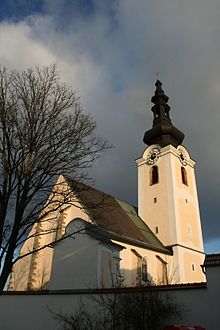
- Catholic parish church Gramastetten hl. Laurentius: In 1110, Bishop Ulrich from Passau consecrated the first church in Gramastetten, which was consecrated to St. Laurentius. A new late Gothic church with a lower church was built in 1440. A representative of the church from 1945 to 1964 was Pastor Father Konrad Just , who was also known as "Don Camillo of the Mühlviertel" for his actions.
- Calvary church Gramastetten
- Premakirche of the five world religions: The private court chapel in Türkstetten was opened on September 18, 2017 by representatives from five world regions, namely Lama Tenzin Sangpo ( Buddhism ), Abbot Reinhold Dessl ( Christianity ), Naresh Sheetal ( Hinduism ), Imam Hussein Haimour ( Islam ) and Ville Lignell ( Judaism ).
- Bath house from the 16th century, home of the doctor and mayor Alois Peither, in the 20th century parish cinema by Pastor Konrad Just
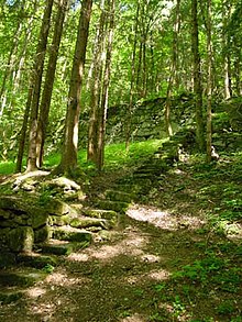
- Annual steps: The market citizen Alois Peither (for details see section “Personalities”) owned the “Kirchleitn”, a very steep slope overgrown with bushes, which was located behind the church and reached up to the Rodl. He had to raise a lot of money to practice cultivation. His plan was to create plantations on the "Kirchleitn" that would primarily benefit the poor. Alois Peither's life's work began with this idea. In 1846 two floors were planted with mulberry trees, which were to be used for silkworm breeding. However, due to the climate, the silkworms could not survive. So he began to cultivate his slope further and in 1876 already had five terraces planted with flowers, shrubs, fruit trees and hops, which were then subsidized by the state. His other cultivation measures included the creation of a vegetable garden and a vine and hop arbor as well as the erection of a beehive. The aim of his life's work was to create work especially for the poor. He needed bricklayers who had to erect and maintain the walls for the terraces. In addition, he needed people to remove brush and trees, carry out blasting, deliver fertilizer and earth, etc. Furthermore, he had the poor build a staircase that leads along the terraces to the valley floor. The staircase consists of 365 steps, which is why it is also called the "annual staircase". Alois Peither has planted an oak on the hill of his "Kirchleitn", from which the annual climb to the Rodl goes. From this place you have a view of the Rodltal and the Lichtenhag castle ruins. With a bench set up around the tree, the place was Peither's favorite place.
Cultural assets
- The Gramastetten song: The song "Mein liebes Gramastett'n" was written on September 26, 1951 in Aussee by Hans Gielge, who was born in Gramastetten. He dedicated the song to the senior teacher Hauser and his beloved place of birth Gramastetten.
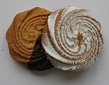
- Specialties from Gramastetten: Gingerbread and rusks have been produced in Gramastetten for 200 years. The rusk was very popular and so it was also produced by companies in Linz that sold the rusks as Gramastetten rusks . It was not until a little later that the Gramastettner Krapferl were invented. These have been known since 1900, but it is unknown how long the Krapferl have been around. The nationally known Krapferl are made from shortcrust pastry according to an old recipe. The first to produce the “Gramastettner Krapferl” was Katharina Humalin. The Hummel family, the descendants of Humalin, continued producing the Krapferl until 1933. A great-nephew of the Hummel family, pastry chef Hermann Knollmayr, carried on the tradition. The Hummel's Backmanufaktur still produces the famous Gramastettner Krapferl and rusks .
Cultural institutions
- ArGe Kultur Gramastetten
- Gramaphone. On October 19, 2008 the Gramaphon was opened as an event center. It was built where the Kaiser Franz Joseph Jubilee School was once located. The gramaphone offers space for a large event hall, a rehearsal room for the band, a pub and the music school.
- KuKuRoots - rooted in art and culture
- Culture Starzerhof
- Upper Austria. Volksbildungswerk in the Landeskulturzentrum Ursulinenhof
- ThekaGram
Sports and leisure center
The construction of a sports and leisure center started on the Peitherwiese in 1980. The center, which opened on May 6, 1984, consists of five tennis courts, two soccer fields and a club building. The sports center was expanded in 1999 to include a pole sports hall and a climbing wall. Furthermore, five stock lanes were roofed over to offer the athletes the best possible training conditions.
Tourism and leisure
In the municipality of Gramastetten, which borders the state capital Linz, you can relieve your everyday stress and find relaxation. Gramastetten has become a popular destination. The community had a nature trail set up, where hikers can read information about native animals and woods in showcases. This educational trail leads to the annual climb, which is a must for experienced hikers. After a hike on the Rodl, the idyllic natural forest pool, which is located in a forest clearing, invites you to swim. The toboggan pool offers refreshing water, showers, a playground for children, a buffet and is free to use.
A hike to the Bildgraben or Augenbründlein is another hiking option that Gramastetten has to offer. The Augenbründlein is a mountain spring to which numerous people used to make a pilgrimage to cure their eye problems with this spring water. This hiking route offers a wonderful view of the Mühlviertel hill country.
Another hiking route is the Riesensteinwanderweg, which, as its name suggests, leads to the Riesenstein. On this hike you have a beautiful view of the Lichtenhag castle ruins and Gramastetten.
Economy and Infrastructure
Public facilities
A new water pipe was built in 1947 by the water cooperative, which is privately run. The lines have been constantly expanded and renewed, are state-of-the-art and supply most households. In the 1990s, the systems were expanded to include a deacidification system . Due to the growing number of the population and after large periods of summer drought, a connection to the long-distance water supply Mühlviertel was made. The fully developed pipeline network has a length of 45 km and supplies the market and the peripheral areas with digestible drinking water.
The local sewer system was built in 1958 and 1961.
In 1993, a business park on Hansberg Landesstrasse in Türkstetten was built outside the market on part of the Ortner grounds that were acquired by the municipality. Local residents as well as new businesses thus had the opportunity to develop.
District retirement home
In 1970 the construction of the district nursing home began behind the rectory. After two years, the old people's home was finally inaugurated on December 3, 1972. After the building had been empty since 2005, it was demolished in 2009. As a result, a new district seniors' home was built by the Urfahr-Umgebung social welfare association. It offers 96 care places and four short-term places and was officially opened on September 17, 2011.
Municipal businesses
Among the companies that are privately run by the market town of Gramastetten
- the community kindergarten
- the community library
- the school lunch as well
- the student crèche.
education
- Library of the market town of Gramastetten
- kindergarten
- Parish Caritas Kindergarten
- Elementary school
- secondary schools
- Polytechnic school
- Student crèche
- State Music School Gramastetten
- Source:
gastronomy
In Gramastetten there is a pastry shop with a café, three inns, a bed and breakfast, a sausage stand, a snack station, a petrol station and a sports parlor with Sky football broadcasts.
The Vedahof (compare: Veda ), a Mühlviertel three-sided courtyard that was laid out 700 years ago, is a frequented wedding location , to which a private church for 5 world religions (see sights) has belonged since September 2017 .
Personalities
- Honorary citizen of the community
- Alois Peither (1816–1906): Honorary citizen for his social achievements as a benefactor and community doctor Alois Peither was born on February 16, 1816 in Waldhausen . He was considered the great benefactor for the poor in Gramastetten. In 1841 Peither came to the community as a wound and obstetrician and practiced until 1899 as a community doctor for Gramastetten and Eidenberg. Alois Peither died on December 10, 1906 at the age of 90. A chapel built on Eidenberger Strasse in 1894, the “Peither Chapel”, still commemorates the great benefactor. Peither wanted someone to inherit his "Kirchleitn" who would continue his social project after his death. It was his wish that the poor benefit from the income from the "Kirchleitn". However, Peither's successor could not fulfill the wish for financial reasons. On December 31, 1925, twenty years after Alois Peither died, the oak that was once planted by the great benefactor was felled. According to the annual rings, this tree was 100 years old. In the course of time the retaining walls of the terraces and the annual staircase began to deteriorate until the staircase was renovated in 1975. Peither Foundation: Peither also owned a piece of land for his chapel named after him, which he bequeathed to Gramastetten. However, he only bequeathed the land to the church on condition that the poor in the church benefit from the proceeds.
- Sons and daughters of the church
- Vinzenz Übeleis (1889–1967), politician of the SPÖ , member of the National Council 1945–1953, Federal Minister of Transport 1945–1949
- Hans Gielge (1901–1970), teacher of cultural activist, collector of folk songs, creator of the Gramastettner Lied and dialect poet
- Gebhard Rath (1902–1979), Roman Catholic clergyman, Cistercian, archivist and Nazi victim
- Alfred Sageder (1933–2017), rower
- Leopold Lummerstorfer (* 1968), film director, film producer, screenwriter
- People related to the community
- Harald Berger (1972-2006), three-time world champion in ice climbing
- Ernst Hack (1946–1986), wrestler
- Franz Hartl (1901–1970), community secretary of Gramastetten, state fire brigade commander of Upper Austria and member of the state parliament (ÖVP)
- Konrad Just (1902–1964), Roman Catholic clergyman, Cistercian, Nazi victim, concentration camp prisoner; former pastor of the community of Gramastetten
- Vincent Kriechmayr (* 1991), ski racer
- Leonora Leitl (* 1974), graphic designer, illustrator and author
- Inge Loidl (* 1926), Roman Catholic functionary
- Franz Pühringer (1906–1977), journalist, poet and playwright
Others
The main belt asteroid (175730) Gramastetten was named after the market town.
literature
- Thomas Schwierz (author), Gramastetten working group for small monuments. Herbert Ginterseder, Herbert Rechberger, Adolf Lehner (eds.): Sacred small monuments and memorials in Gramastetten. 1. Volume of the Gramastettner Heimatbuch, Gramastetten 2003, 300 pages.
- Thomas Schwierz (author), Gramastetten working group for small monuments. Herbert Ginterseder, Herbert Rechberger, Adolf Lehner (eds.): Traces of bygone times. Historical evidence and stories from Gramastetten. 2nd volume of the Gramastettner Heimatbuch, Gramastetten 2005, 357 pages.
- Thomas Schwierz (author), Gramastetten working group for small monuments. Herbert Ginterseder, Herbert Rechberger, Adolf Lehner (eds.): 900 years of Gramastetten history, present and outlook of a Mühlviertel parish. 3rd volume of the Gramastettner Heimatbuch, Gramastetten 2009, 766 pages.
Web links
- 41609 - Gramastetten. Community data, Statistics Austria .
- Website of the market town of Gramastetten
- Further information about the municipality of Gramastetten can be found on the geographic information system of the federal state of Upper Austria .
- Map in the Digital Upper Austrian Room Information System ( DORIS )
- Thomas Schwierz: 900 years of Gramastetten. In: EuroJournal Linz - Mühlviertel - Bohemian Forest. 15th year, Heft 4, Linz 2009, p. 4–7, online (PDF) in the forum OoeGeschichte.at (short version of the Heimatbuch)
- Municipal archive Gramastetten on landesarchiv-ooe.at (20 documents from the years 1518–1798)
- Literature on Gramastetten in the forum OoeGeschichte.at
Individual evidence
- ↑ Statistics Austria: Population on January 1st, 2020 by locality (area status on January 1st, 2020) , ( CSV )
- ↑ Karl Hohensinner , Peter Wiesinger : Place Name Book of the Province of Upper Austria 10. The place names of the political district Urfahr-Umgebung (Middle Mühlviertel). Vienna 2006.
- ↑ Schwierz 2009, maps p. 87 and p. 114.
- ↑ Documents No. 1 and No. 3 in the municipal archive
- ^ Parish office Gramastetten: A small historical picture on the occasion of the celebration of the 800th anniversary of the parish. Linz 1910, digitized on digi.landesbibliothek.at, p. 21.
- ↑ Document No. 12 in the municipal archive
- ↑ Schwierz 2009, p. 215.
- ↑ Schwierz 2009, pp. 242–245.
- ↑ Schwierz 2009, p. 302.
- ↑ a b Gramastetten under fire: The last days of the 2nd World War in Gramastetten on grimhard.at
- ^ Statistics Austria, A look at the community of Gramastetten, population development. Retrieved May 3, 2019 .
- ^ Province of Upper Austria, results of the 2015 elections. Retrieved on May 3, 2019 .
- ↑ Schwierz 2009, p. 152.
- ↑ Church for five religions in Gramastetten on orf.at, September 19, 2017.
- ↑ Benefactor Peither on grimhard.at
- ↑ Gramastettner Lied (PDF) on the community website
- ↑ a b Schwierz 2009, pp. 269–271.
- ↑ Schwierz 2009, p. 449.
- ↑ a b c Gramastetten excursion and recreation site on the municipality's website
- ↑ Gramastetten Water Cooperative at ooewasser.at
- ↑ Homepage of the Gramastetten water cooperative at wassergenossenschaft.or.at
- ↑ Schwierz 2009, p. 447.
- ↑ The Gramastetten District Seniors' Home on shvuu.at, the homepage of the Urfahr-Umgebung social welfare association
- ↑ a b School and childcare on the municipality's website
- ↑ Gastronomy on the municipality's website
- ↑ Homepage of the Veda-Hof on vedahof.com
- ↑ a b c The Alois Peither Foundation on grimhard.at
- ↑ Bader Alois Peither on grimhard.at
- ^ Gielge, Hans In: Österr. Music lexicon online, OeAW


