
Walding
|
market community Walding
|
||
|---|---|---|
| coat of arms | Austria map | |
 |
|
|
| Basic data | ||
| Country: | Austria | |
| State : | Upper Austria | |
| Political District : | Urfahr environment | |
| License plate : | UU | |
| Surface: | 15.32 km² | |
| Coordinates : | 48 ° 21 ' N , 14 ° 10' E | |
| Height : | 303 m above sea level A. | |
| Residents : | 4,158 (January 1, 2020) | |
| Population density : | 271 inhabitants per km² | |
| Postal code : | 4111 | |
| Area code : | 07234 | |
| Community code : | 4 16 26 | |
| NUTS region | AT312 | |
| Address of the municipal administration: |
Hauptstrasse 19 4111 Walding |
|
| Website: | ||
| politics | ||
| Mayor : | Johann Plakolm ( ÖVP ) | |
|
Municipal Council : (2015) (25 members) |
||
| Location of Walding in the Urfahr-Umgebung district | ||
  |
||
| Source: Municipal data from Statistics Austria | ||

Walding is a market town in the Mühlviertel in the Urfahr-Umgebung district in Upper Austria with 4158 inhabitants (as of January 1, 2020). The community is located in the judicial district of Urfahr .
geography
Walding is at an altitude of 303 m above sea level. A. in the Mühlviertel. The extension is 5.5 kilometers from north to south and 5.4 kilometers from west to east. The total area of the core town, which is essentially northeast of Rohrbacher Straße (B 127), is 15.3 square kilometers.
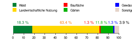
Area distribution
Districts
|
|
|
Neighboring communities
| Saint Gotthard | Gramastetten | |
| Feldkirchen on the Danube |
.svg)
|
|
| Goldwörth | Ottensheim |
coat of arms
Blazon : Divided humiliated by a golden wavy bar; Above split by silver and red with a paw cross in alternating colors, below green. The community colors are red and yellow.
history
Originally located in the eastern part of the Duchy of Bavaria , the place belonged to the Duchy of Austria since the 12th century. Since 1490 it has been assigned to the Principality of Austria ob der Enns . The Burgstall Waltenstein goes back to this time .
In the 18th century Walding had supraregional importance as a place of pilgrimage ("Maria Walding"), but lost this status due to the intervention of the gentlemen from Pöstlingberg, who shied away from competition. During the Napoleonic Wars , the place was occupied several times and has since returned to Upper Austria.
After Austria was annexed to the German Reich on March 13, 1938, Upper Austria became the Gau Oberdonau . After 1945 the restoration of Upper Austria took place.
Population development

The sharp increase in population from 1981 to 2001 took place because both the birth balance and the migration balance were positive. The birth balance has been negative since 2001 and growth is due to immigration.

economy
In Walding there are 76 agricultural and forestry businesses, 29 of which are full-time businesses (as of 2010). In the secondary economic sector, 29 companies employ 175 people, mainly in the manufacture of goods and in construction. The tertiary economic sector provides work for 864 people in 210 companies. The focus is on trade and social and public services (as of 2011).
traffic
train
The Mühlkreisbahn runs through Walding and Rottenegg . There is a train stop south of Walding. In Rottenegg there is a train station where half of the trains on the Mühlkreisbahn end. The Mühlkreisbahn is a self-service route between Linz and Rottenegg.
bus
In addition to the Mühlkreisbahn, there are Postbus stops on the B127 in the districts of Walding and Rotteneg and on the B131 in the district of Lindham.
Culture and sights
- Walding zoo and riding stables
- Parish church : with new glass windows by the artist Alfred Stifter
gallery


Personalities
- Ferdinand Weeser-Krell (1883–1957), industrial painter and son Jakob Weeser-Krell , lived in Schwarzgrub 28 in the 1930s.
- Claudia Plakolm (* 1994), ÖVP politician
Web links
- 41625 - Walding. Community data, Statistics Austria .
- Further information about the municipality of Walding on the geo-information system of the federal state of Upper Austria .
- Map in the Digital Upper Austrian Room Information System ( DORIS )
- Official website of the market town of Walding
Individual evidence
- ^ State of Upper Austria, history and geography, coat of arms. Retrieved May 4, 2019 .
- ^ Statistics Austria, A look at the community of Walding, population development. Retrieved May 4, 2019 .
- ^ Statistics Austria, A look at the community of Walding, agricultural and forestry operations. Retrieved May 4, 2019 .
- ^ Statistics Austria, A look at the community of Walding, workplaces. Retrieved May 4, 2019 .
- ^ Statistics Austria, A look at the community of Walding, employees. Retrieved May 4, 2019 .
- ^ ÖBB Postbus. Retrieved May 9, 2018 .

Alberndorf in the Riedmark | Altenberg near Linz | Bad Leonfelden | Eidenberg | Engerwitzdorf | Feldkirchen an der Donau | Gallneukirchen | Goldwörth | Gramastetten | Haibach im Mühlkreis | Hellmonsödt | Herzogsdorf | Kirchschlag near Linz | Lichtenberg | Oberneukirchen | Ottenschlag in the Mühlkreis | Ottensheim | Puchenau | Reichenau im Mühlkreis | Reichenthal | Schenkenfelden | Sonnberg in the Mühlkreis | St. Gotthard in the Mühlkreis | Steyregg | Vorderweißbach | Walding | Zwettl on the Rodl