
Lichtenberg (Upper Austria)
|
Lichtenberg
|
||
|---|---|---|
| coat of arms | Austria map | |
 |
|
|
| Basic data | ||
| Country: | Austria | |
| State : | Upper Austria | |
| Political District : | Urfahr environment | |
| License plate : | UU | |
| Main town : | Altlichtenberg | |
| Surface: | 18.59 km² | |
| Coordinates : | 48 ° 22 ' N , 14 ° 15' E | |
| Height : | 620 m above sea level A. | |
| Residents : | 2,728 (January 1, 2020) | |
| Population density : | 147 inhabitants per km² | |
| Postal code : | 4040 | |
| Area code : | 07239 | |
| Community code : | 4 16 14 | |
| NUTS region | AT312 | |
| Address of the municipal administration: |
At Ortsplatz 1 4040 Lichtenberg |
|
| Website: | ||
| politics | ||
| Mayoress : | Daniela Durstberger ( ÖVP ) | |
|
Municipal Council : (2015) (25 members) |
||
| Location of Lichtenberg in the Urfahr-Umgebung district | ||
  |
||
| Source: Municipal data from Statistics Austria | ||

Lichtenberg is a municipality in the Urfahr-Umgebung district in Upper Austria with 2728 inhabitants (as of January 1, 2020). The community is located in the judicial district of Urfahr .
Lichtenberg is a typical catchment area in the Linz agglomeration with a high proportion of commuters and little local infrastructure. The city center of Linz can be reached in around 20 minutes by car.
geography
Lichtenberg lies at an altitude of 620 m above sea level. A. in the upper Mühlviertel . The expansion is 5.6 km from north to south and 5.4 km from west to east. The total area is 18.4 km². A large part of the municipality is located on the Lichtenberg of the same name, 927 m high .
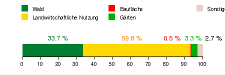
Area distribution:
The municipality includes the following localities (population in brackets as of January 1, 2020):
- Altlichtenberg (1223)
- Asberg (501)
- Haselgraben (7)
- Chamber punch (11)
- Kronabitedt (5)
- Muhlberg (197)
- Neulichtenberg (784)
Neighboring communities
| Eidenberg | Kirchschlag near Linz | |
.svg)
|
||
| Gramastetten | Linz |
history
Originally located in the eastern part of the Duchy of Bavaria, the place belonged to the Duchy of Austria since the 12th century . The parish of Gramastetten was founded around 1110 , to which part of the Lichtenberg municipality still belongs today. "Walther de Liechtenperch" (beginning of the 13th century), "Otacharus de Lithenberch" (1220) and "Pillungus de Liechtenperg" (1270) were the first to mention the place name, whereby the place name comes from a clearing or from the cleared mountain . During the Middle Ages the population certainly did not exceed the order of 200–500. In the municipality of Lichtenberg, however, several medieval fortifications have been identified or are suspected to be there:
Since 1490 the area has been assigned to the Principality of Austria ob der Enns . The plague claimed great victims in the Mühlviertel in 1680, it is said that several people died of the disease in Lichtenberg as well.
In 1785 the Pöstlingberg parish was founded , which means that the surrounding parish area was restructured. As early as 1770, localities were ordained with numbering of houses, especially from a military point of view to make it easier to record those who were fit for military service. This house numbering was only replaced in 1994 by the introduction of street names.
During the Napoleonic Wars , the place was occupied several times. In May 1809 combat troops of the imperial army marched through Lichtenberg to attack the French bridgehead in Urfahr.
In 1850 the municipality of Lichtenberg was created, but in 1875 it was combined with Pöstlingberg and Katzbach to form the municipality of Pöstlingberg .
After the First World War , the village of Pöstlingberg was connected to the neighboring Urfahr , shortly afterwards Urfahr to the state capital Linz , and the remaining Lichtenberg was rebuilt as an independent municipality. In the constituent meeting of the municipal council, Leopold Hemmelmayr was elected first mayor in 1919.
After Austria was annexed to the German Reich on March 13, 1938, Upper Austria became the Gau Oberdonau . After 1945 the restoration of Upper Austria took place. The initially American occupation was replaced by the Russian.
Since the 1970s , the originally primarily agricultural community has transformed into a preferred settlement area in the Linz conurbation. This brought with it a corresponding increase in the population: from 1979 to 2005 the number of inhabitants rose from 1,544 to almost 2,500.
There is no actual, historically grown town center. Rather, Lichtenberg comprises individual localities, with larger contiguous building areas only to be mentioned in Neu- and Altlichtenberg. In Altlichtenberg there is a municipal office, elementary school, kindergarten, gym and parish center. For some time now there have been efforts to build a new town center here.
population
Population structure
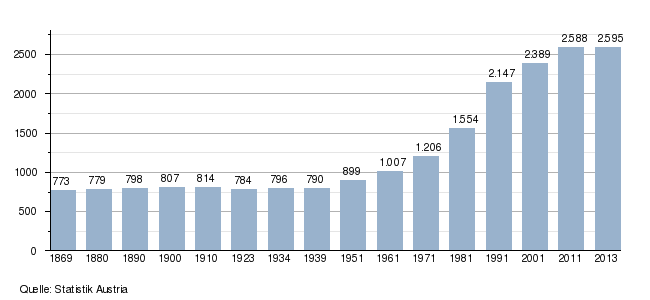
In 2013, 2,595 people lived in the municipality of Lichtenberg, placing Lichtenberg in the middle of the range of the municipalities in the Urfahr-Umgebung district. In terms of population density, Lichtenberg had the seventh-highest population density of the 27 municipalities in the district with 140 inhabitants per km². At the end of 2001, 98.9 percent of the population were Austrian citizens (Upper Austria 92.8 percent, Rohrbach district 97.9 percent), by the beginning of 2013 the value had fallen marginally to 98.0 percent (Upper Austria 91.1 percent, Rohrbach district 96, 9 percent). In 2013, only 53 foreigners were counted in the municipality, 87 percent of whom came from EU countries. In 2001, 85.1 percent of the population committed to the Roman Catholic Church (Upper Austria: 79.4 percent), 10.8 percent were without confession and 1.8 percent were Protestants.
The average age of the community population in 2001 was slightly below the national average. 19.2 percent of the residents of Lichtenberg were younger than 15 years (Upper Austria: 18.8 percent), 63.9 percent between 15 and 59 years old (Upper Austria: 61.6 percent). The proportion of residents over 59 years of age was 16.9 percent, well below the national average of 20.2 percent. As a result, the average age of the population of Lichtenberg changed, especially in the first two segments. The proportion of people under the age of 15 fell to 15.5 percent as of January 1, 2013, while the proportion of people between the ages of 15 and 59 increased significantly to 67.8 percent. The proportion of people over 59 years of age, however, fell to 16.8 percent. According to their marital status, in 2001 42.6 percent of the residents of Lichtenberg were single, 48.8 percent married, 4.1 percent widowed and 4.6 percent divorced.
Population development
Today's municipality of Lichtenberg experienced practically no changes in population between 1869 and 1939. Rather, the population fluctuated between around 770 and 810 residents. This meant that the average population development in the Urfahr-Umgebung district was below that of the federal state of Upper Austria. Due to its quality as a neighboring municipality of the state capital Linz, however, Lichtenberg recorded an above-average population growth after the Second World War , which has more than tripled the population since 1939. The population growth was particularly strong in the 1970s and 1980s. In addition to immigration, Lichtenberg also has a strongly positive birth balance. Between 1971 and 2001, the population increased by around 150 people per decade. In addition, immigration was already higher than the birth surplus in the 1970s and more than doubled in the 1980s when the migration balance was a positive value of more than 400 people. In the 1990s, however, immigration fell sharply and much to only around a quarter of the 1980s. Since the turn of the millennium, the population of Lichtenberg has increased more or less balanced by immigration and a positive birth balance.
coat of arms
Blazon : In blue on a golden three-mountain, a red-silver-red divided, upwardly tapering mast, in the lower part equipped with two short, silver strips and on top of them two silver bowls; Silver triple corrugated strips starting from the top of the mast. The community colors are blue-yellow.
politics
The municipal council has a total of 25 members. With the municipal council and mayoral elections in Upper Austria in 2015 , the municipal council has the following distribution: 16 ÖVP, 6 SPÖ and 3 FPÖ.
- mayor
- 1997-2008 Johann Durstberger (ÖVP)
- since 2008 Daniela Durstberger (ÖVP)
Economy and Infrastructure
Workplaces and employees
The municipality of Lichtenberg benefits little in the economic sector from its proximity to the economic center of Upper Austria Linz. In 2001 the community only housed one company with 20 or more employees. In total there were only 76 workplaces with 239 employees in the municipality (excluding agriculture), 70 percent of which were employed. The number of workplaces had risen by 24 (plus 46 percent) compared to 1991, the number of employees by 72 people (plus 43 percent). The most important branch of the economy in 2001 was the production of goods with seven workplaces and 50 employees (21 percent of all employees), followed by trading with 16 workplaces and 41 employees (17 percent) and the real estate / business services sector with 19 workplaces and 34 employees (14 percent). Other important branches of the economy were education and the "provision of other public and personal services". 38 percent of the employees in Lichtenberg were salaried employees or civil servants, 26 percent blue-collar workers and 23 percent business owners.
Of the 1,386 economically active persons living in Lichtenberg in 2010, only 1.8 percent were unemployed. Of the 1,361 people in employment, 215 were employed in trade (16 percent), 194 in material goods production (14 percent) and 146 in health and social services (12 percent). Other important sectors were public administration and education with 10 and 9 percent respectively. Of the 1,323 employed people from Lichtenberg (excluding residents temporarily absent from work), only 249 people were employed in Lichtenberg in 2010. 1,074 or 81 percent had to commute to work. Of the out-commuters, 75 percent had their place of work in the provincial capital Linz, in addition, the residents mainly commuted to the districts of Urfahr-Umgebung and Linz-Land. In return, 283 people commuted to Lichtenberg, with one third each coming from Linz and the Urfahr-Umgebung district.
Agriculture and Forestry
In 2010, the statistics showed 69 agricultural and forestry operations for the municipality of Lichtenberg. These included 30 full-time businesses, 36 part-time businesses and two groups of people. The total number of establishments had fallen by 13 establishments or 16 percent compared to 1999, with the number of full-time businesses in particular falling. In 2010, the farms farmed a total of 1,415 hectares, with 68 percent of the area being farmed by full-time farmers and 31 percent by part-time farmers. The average area of full-time farmers was 32 hectares, slightly lower than the Upper Austrian average (33.8 hectares).
Partnerships
-
 Lichtenberg district , Berlin , Germany
 -
Lichtenberg (Upper Franconia) , Germany, since 1994
Culture and sights

- Pastoral care center Lichtenberg
- Gisela waitress
freetime and sports

- Lichtenberg : Large parts of the municipal area are taken up by the 927 m high Lichtenberg. This is also known colloquially as G sharp, named after the 'Giselawarte' on it. This observation tower was completed in 1857 in honor of Archduchess Gisela - a daughter of Emperor Franz Joseph and his wife Elisabeth . The nearby Johann Pollack spring commemorates the alleged building initiator, the Linz businessman Johann Pollack . The Lichtenberg transmitter is located at the top of the mountain .
- Kinderplanetenweg Lichtenberg: an approx. 7 km long circular path that shows the planets true to scale in their proportions and distances. There are informative boards next to the planets that describe them. School classes and parents with children can borrow a rucksack from the municipal office with small experiments that bring the children closer to scientific facts. The concept has already received several awards, including the family Oscar from the Province of Upper Austria. At the Europe-wide science festival "Science on Stage 2011" it received one of the second prizes in Copenhagen .
The Lichtenberg serves the Linz agglomeration as a local recreation area and, along with the Pöstlingberg and Pfenningberg, is one of the classic Linz local mountains at the gateway to the Mühlviertel. When the view is clear, a view far into the foothills of the Alps to the Dachstein massif is impressive . In the cold season, Lichtenberg is mostly above the layers of high fog in the Linz basin .
Connected to the neighboring communities by an extensive network of trails, the Lichtenberg attracts hikers and mountain bikers alike. In winter, several cross-country trails are regularly groomed.
Personalities
- Joschi Anzinger (* 1958), dialect poet
Web links
- 41614 - Lichtenberg (Upper Austria). Community data, Statistics Austria .
- Further information about the municipality of Lichtenberg (Upper Austria) can be found on the geographic information system of the federal state of Upper Austria .
- Map in the Digital Upper Austrian Room Information System ( DORIS )
- Literature on Lichtenberg in the forum OoeGeschichte.at
Individual evidence
- ↑ Numbers and facts. Municipality of Lichtenberg, http://www.lichtenberg.ooe.gv.at , accessed on January 15, 2013 .
- ↑ Statistics Austria: Population on January 1st, 2020 by locality (area status on January 1st, 2020) , ( CSV )
- ↑ Karl Hohensinner , Peter Wiesinger : Ortnamesbuch des Landes Oberösterreich 10. The place names of the political district Urfahr-Umgebung (Middle Mühlviertel). Vienna 2006
- ↑ a b Province of Upper Austria ( Memento of the original from November 29, 2014 in the Internet Archive ) Info: The archive link was inserted automatically and has not yet been checked. Please check the original and archive link according to the instructions and then remove this notice. Population levels in Upper Austria in comparison by citizenship
- ↑ Statistics Austria: Population by religion and federal states 1951 to 2001 (accessed on October 2, 2013)
- ↑ a b c d e Austria municipality data of Altenfelden
- ↑ a b Province of Upper Austria ( Memento of the original from October 29, 2013 in the Internet Archive ) Info: The archive link was automatically inserted and not yet checked. Please check the original and archive link according to the instructions and then remove this notice. Resident population in Upper Austria compared by age group
- ^ Town twinning in the Naila region , accessed on November 21, 2014
- ↑ Children's Planet Trail Lichtenberg
- ^ Science on Stage Europe

Alberndorf in the Riedmark | Altenberg near Linz | Bad Leonfelden | Eidenberg | Engerwitzdorf | Feldkirchen an der Donau | Gallneukirchen | Goldwörth | Gramastetten | Haibach im Mühlkreis | Hellmonsödt | Herzogsdorf | Kirchschlag near Linz | Lichtenberg | Oberneukirchen | Ottenschlag in the Mühlkreis | Ottensheim | Puchenau | Reichenau im Mühlkreis | Reichenthal | Schenkenfelden | Sonnberg in the Mühlkreis | St. Gotthard in the Mühlkreis | Steyregg | Vorderweißbach | Walding | Zwettl on the Rodl