
Urfahr
| Linz district Urfahr | |
|---|---|
 |
|
| Basic data | |
| political district | Linz (L) |
| surface | 4.268 km² |
| Geographical location | 48 ° 19 ′ N , 14 ° 17 ′ E |
| height | 266 m above sea level A. |
| Residents | 23,670 (as of 2017) 5546 inhabitants per km² |
| Post Code | 4040 |

Urfahr is a district of Linz in Upper Austria north of the Danube . It borders on the districts of Pöstlingberg and St. Magdalena and, south of the Danube, on Froschberg , Innere Stadt and Kaplanhof . Urfahr was a separate municipality until it was incorporated into Linz in 1919. Colloquially, all districts of Linz north of the Danube, including Pöstlingberg and St. Magdalena, are often counted as Urfahr.
history

The name Urfahr developed from the word Überfahrt , which was necessary to get there from Linz or to ship the salt from the Linz loading stations across the Danube, so that it could be transported via the Linzer Steig network to Freistadt , Leonfelden or Schenkenfelden and further could be transported to Bohemia . From 1288, the name Urfahr was used in Linz documents to determine the place of residence of the citizens of Linz, but at that time it was still on the right bank of the Danube, where the Urfahrt gate, first mentioned in 1318, was also located. In 1360 Urfahr appears for the first time undoubtedly as the name for today's town on the left bank of the Danube, in the will of the widow of the respected Linz citizen Otto Maywiser.
A " letter of grace " from Emperor Friedrich III. from 1492 allowed the Urfahranern to build a chapel and to have masses read by the Irish priest and his caplain . A townscape of 1511/13 shows the now-defunct St. Nicholas Church as a high Gothic building with skylights. A request for market survey submitted at the same time was rejected. In the 15./16. A noble seat in Harbach is mentioned in the 19th century .
Because an ice rush had torn four yokes of the Danube bridge away, the original voyagers and Linz shipmen had every effort to get the notorious Passau soldiers across the Danube in 1611.
Urfahr market (1808–1882)

The Urfahraner have sought market rights again and again since 1492. In 1635, the Steyregg lordship tried to gain market freedom for Urfahr. In 1709, 1717, 1753 and 1769 the Wildberg lordship repeatedly and in vain advocated the market survey, because the authorities always gave priority to protecting the old Linz city privileges. On December 16, 1808, Urfahr finally received market rights , which the people of Linz had resisted for centuries.
The market survey was the prerequisite that Emperor Franz I approved a (half) annual festival in Urfahr on March 20, 1817, the Urfahraner Markt or Urfahr Market. Only since 1902 has the fair been held on the Urfahraner Donaulände, the fairgrounds, and attracts thousands of visitors. In addition to amusement facilities, there are also large exhibition halls. The fairgrounds are also used for concerts.
City of Urfahr (1882–1919)
On November 4, 1882, Urfahr was elevated to town. From 1832 to 1872 the horse-drawn railway connected Budweis – Linz – Gmunden Urfahr with Bohemia and the Salzkammergut . Since 1888 connects Mühlkreisbahn the Linz-Urfahr station with landscape makes the upper Mühlviertel . In 1919, the community of Pöstlingberg, in which the pilgrimage basilica is located, was incorporated into Urfahr, shortly afterwards Urfahr itself was incorporated into Linz. At the time of incorporation, Urfahr had around 15,000 inhabitants, making it the largest city in the Mühlviertel and the district town of the Urfahr district .
Modern times

From 1945 until the end of the occupation in 1955, Linz was divided along the Danube. The north (Urfahr) was occupied by the Soviets, the south (Linz) by the Americans. The zone boundary was the bridgehead of the Nibelungen Bridge on the Urfahran side.
Before the construction of the New Town Hall , extensive renovation work was carried out in Alt-Urfahr West in 1975 and the building of the former Nikolaikirche, which was now used as a residential building, was demolished. The completed New Town Hall opened on September 27, 1985.
In 1995 there was a rampage at the Urfahr-Umgebung district court (see Urfahr rampage ).
In 2007 the mobile flood protection dam Alt-Urfahr West was completed. The construction of this flood protection was decided after the Danube flood in 2002 flooded this district up to 1.7 meters. The mobile flood protection dam in Krems , which had passed its practical test in 2002, served as a model .
With the restructuring of the statistical districts of Linz in 2014, the former districts of Alt-Urfahr, Heilham, Hartmayrsiedlung, Harbachsiedlung , Karlhofsiedlung and Auberg were merged into Urfahr, Pöstlingberg and St. Magdalena.
coat of arms

Blazon : "In the blue shields a city gate of white masonry on green, querverlaufendem shores of the edge of river flowing through the river Danube, consisting of a mutually stepped middle wall between two towers, with a black, a golden portcullis containing Thor opening between gold Thor wings and two windows from which diverging a silver road descends to the water and which is overlaid by a golden plaque marked FJI, black. Each tower has a pointed roof with a golden weather flag over three pointed battlements, then an arched window at the top and a transverse gap at the bottom and stands on a sloping square base, all roofing is golden. Crossing the stream is a transfer neck striped in gold and black diagonally to the left, in the star with a flag with white crossbars, rowed by a ferryman and taken by a passenger sitting back in his beak, each dressed in a red doublet, black trousers and red knee socks and covered with a white feathered black felt hat with a wide brim. Above the Thordache hovers a longitudinally divided shield, which on the right contains a golden, red-tongued eagle in the black field, and on the left is staked four times in silver and red. The shield is surrounded by an architecturally held arabesque, which has a five-pinned wall crown, both are brown in color. "
The coat of arms was awarded on the occasion of the town elevation in 1882 by Emperor Franz Josef . It was already listed in this form, without F. J. I. , before the market survey in 1808.
building
See also the list of listed objects in Linz-Urfahr
- The Urfahr Josefskirche , consecrated in 1702, was a Capuchin church and in 1784 became the parish church of Urfahr.
- The Christkönig parish church , also known as the Church of Peace , was consecrated in 1951.
- The parish church of St. Leopold , built from 1969 to 1971, was rebuilt after a fire in 1986.
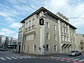
- The old town hall of Urfahr with its Art Nouveau facade is at Rudolfstraße 18.
- The New Town Hall of Linz was built in Urfahr between 1980 and 1985.
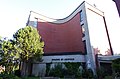
- The Ars Electronica Center was opened in 1996 .
- The Anton Bruckner Private University , which opened in 2015, is located on the site of the former Hagen Castle , of which only the beer hall remains.
- The Lentia 2000 residential and commercial high-rise is one of the most striking buildings in Urfahr.
- The Stadtwerkstatt is a cultural center.
- The Gasthof Fischerhäusl , built in 1642, is located in Flußgasse .
- Despite its urban character, there are still a few farms (including traditional square ones) in Urfahr , see list of farms in Linz # Urfahr

The New Town Hall with the towers of Lentia 2000

Ars Electronica Center and Josefskirche
Old Town Hall
Parish church hl. Leopold

Friedenskirche

Fischerhäusl

City workshop
Hitler buildings in the Karlhofsiedlung


.JPG)

.JPG)


Personalities
- Anton Estermann (1890–1970), architect and politician, born in Urfahr
- Alois Rodlauer (1897–1974), fighter pilot of the First World War with 5 aerial victories, born in Urfahr
- Alfred Hoffmann (1904–1983), economic historian and university professor, born in Urfahr
- Karl Böcklinger (1916–1977), Catholic clergyman, canon of the Linz cathedral chapter and full professor of moral theology
- Franz Angel (1919–1974), mineralogist, petrograph and university lecturer, born in Urfahr
Mayor of Urfahr
Since the municipal law of September 19, 1849, there have been the following mayors for the Urfahr administrative unit:
- 1849–1856: Karl Wischer (1797–1856). Last market judge and first mayor of Urfahr
- 1856–1861: Josef Steinbauer (1796–1869)
- 1861–1867 and 1873–1875: Johann Michael Schwarz (1812–1875), pharmacist
- 1867–1873 and 1875–1886: Leopold Stadlbauer, Kreuzwirt
- 1886–1894: Josef Kaar (1830–1894)
- 1894–1901: Andreas Ferihumer, landlord and wine merchant
- 1901–1919: Heinrich Hinsenkamp (1862–1934)
From 1945 to 1955, the part of the city of Linz north of the Danube was under Soviet occupation. During this time there was Ferdinand Markl (1898-1960) again a mayor of Urfahr, who was responsible for the entire northern part of the city of Linz.
Linz Danube bridges

Maximilian I's bridge letter of March 3, 1497 allowed a connection between Linz and Urfahr for the first time . These bridges remained wooden structures for centuries; an iron bridge was not completed until 1872. The construction of today's Nibelungen Bridge was ordered by Adolf Hitler on May 13, 1938 . From July 27, 1945 to June 8, 1953, the Nibelungen Bridge was the border crossing between the American (south of the Danube) and Russian (north of the Danube) occupation zone .
The railway bridge , which opened on November 14, 1900, was demolished in the summer of 2016. As a successor, a new combined bridge has been built since July 2018, which as a Danube crossing offers two lanes as well as footpaths and cycle paths as well as space for a new tram axis.
The VÖEST bridge named after VÖEST has existed as part of the A7 Mühlkreisautobahn since December 16, 1972 .
A fourth Danube bridge between Urfahrwänd and Oberer Donaulände, which should have opened in 2015, has been discussed for decades. This will be part of the planned A26 Linz motorway .

Voest Bridge

Abandoned railway bridge


Trivia
The inhabitants of Urfahr are called Urfahraner . Compared to other districts of Linz, parts of the older generation in Urfahr have a particularly pronounced local patriotism - according to Roman Sandgruber, historically conditioned .
The Linz district of Urfahr also found its appreciation in music; so wrote Hans Lang and Erich Meder the famous song from Urfahr was my ancestor , which was interpreted as a consequence also with other texts such. B. as in the Tröpferlbad or in the tram from Pirron and Knapp .
Werner Brüggemann composed the Urfahraner song .
The band Attwenger began their career in 1989 with the previous band Urfahraner Durchbruch .
literature
- Anton Ziegler: Review of the history of the city of Urfahr a. D. in Upper Austria. Linz 1920, 208 pages, online at digi.landesbibliothek.at.
- Norbert Kriechbaum: On the prehistory of the Urfahr parish. In: Historisches Jahrbuch der Stadt Linz 2001. Linz 2003, pp. 379–385, online (PDF) in the forum OoeGeschichte.at.
Web links
- Bibliography on Linz Urfahr in the forum OoeGeschichte.at
Individual evidence
- ↑ incorporation; Province of Upper Austria 1919
- ↑ a b Ziegler 1920, p. 18f.
- ↑ Kriechbaum 2003, p. 380.
- ↑ Rudolf Lehr: State Chronicle of Upper Austria. Christian Brandstätter Verlag, Vienna 2008, ISBN 978-3-85498-331-6 , p. 364.
- ↑ Kriechbaum 2003, p. 385.
- ↑ Rudolf Lehr: State Chronicle of Upper Austria. Verlag Christian Brandstätter, Vienna 2008, ISBN 978-3-85498-331-6 , p. 483 (opening).
- ↑ Timeline of the 21st century on stadtgeschichte.linz.at.
- ↑ Archived copy ( memento of the original from September 30, 2007 in the Internet Archive ) Info: The archive link was inserted automatically and has not yet been checked. Please check the original and archive link according to the instructions and then remove this notice.
- ↑ linz.at: Stadtgebiet - Statistische Bezirke (restructuring 2014), accessed on February 15, 2017.
- ↑ Ziegler 1920, p. 92.
- ↑ Ziegler 1920, p. 91f.
- ↑ Ziegler 1920, p. 156.
- ↑ http://www.linz.gv.at/strassennamen/Default.asp?action=strassendetail&ID=3113 Wischerstraße
- ↑ http://www.linz.gv.at/strassennamen/Default.asp?action=strassendetail&ID=2953 Steinbauerstraße
- ↑ http://www.linz.gv.at/strassennamen/Default.asp?action=strassendetail&ID=2934 Schwarzstraße
- ↑ http://www.linz.gv.at/strassennamen/Default.asp?action=strassendetail&ID=1973 Kaarstraße
- ↑ http://www.linz.gv.at/strassennamen/Default.asp?action=strassendetail&ID=1839 Hinsenkampplatz
- ↑ http://www.linz.gv.at/strassennamen/Default.asp?action=strassendetail&ID=1702 Ferdinand-Markl-Straße
- ^ History of the City of Linz and Timeline 1848–1900 In: linz.at, accessed on February 15, 2017.
- ↑ Kerstin Scheller: Shared togetherness on the water. The standard of October 13, 2014, accessed October 2, 2018.
- ↑ See song text Mir san Urfahraner. (PDF) by Florian Schön.
- ↑ Maria Andergast, Hans Lang: My ancestor was from Urfahr. on youtube.com.
- ↑ Werner Brüggemann - Urfahraner song. on discogs.com.