
Nibelungen Bridge (Linz)


The Nibelungen Bridge in Linz connects the city center and Urfahr districts . It runs in a north-south direction over the Danube waterway and is 250 meters long, 30 meters wide and rests on two concrete pillars. The bridge passage width between the pillars is 90.1 meters, the passage height 7.52 m at the standard level. It is the westernmost of the four Danube bridges in Linz. The bridge was built from 1938 to 1940 right next to the place where the first and for a long time the only bridge in Linz was built around 1500. The old one was demolished after the new one was completed.
The backwater of the Abzüge-Asten power plant is located a little below the bridge, varying somewhat with the flow and the weir system. From there the water level becomes almost horizontal, the flow speed decreases and the deposition of gravel and mud increases. In the 1980s the Danube was frozen over here for the last time - after a long time.
Furnishing
The Nibelungenbrücke has six lanes (three each in both directions), 900 mm - tram tracks in the middle as well as laterally and about 20 cm raised walkways , each with a set-up cycling track , covered with about 1 meter square granite slabs on both edges of the bridge .
In the center rises a row of 9 12 m high masts that carry the overhead tram line, flags and lights - two next to each other. The side railings were increased from 90 to 110 cm in 1990 and each carry 17 spherical lights at a height of 3.5 m.
The structure has been prominently illuminated since around 2009 (illuminated by 49 <17 inclined brackets each), shows the channel for navigation on the waterway and carries radar reflectors on horizontal, guyed brackets above and below the water above both support pillars .
Various supply lines lie in the bed of the sidewalk and hidden in the underside of the structure.
history
Previous bridges in the same location
In place of the Nibelungen Bridge there was already a wooden bridge from 1497 / restoration in 1501 , which on the one hand connected the village of Urfahr with the city of Linz, but on the other hand the much more important function of a connection between all lands south of the Danube with all those north of the Danube depicted. The permission to build this first Danube bridge (after Vienna 1439 and Krems / Mautern 1463 it was the third Danube bridge ever in the Duchy of Austria ) in Linz came from the Roman-German King and later Emperor Maximilian I , who did this on March 3, 1497 in the so-called "Bridge letter" allowed.
From around 1832, tracks also ran over the bridge for the first time, as the Budweis – Linz – Gmunden horse-drawn railway between Budweis and Linz was completed. In 1869 the construction of an iron bridge began on the same site. On the Urfahraner side, however, the bridge no longer led into the “Platzl”, but into the Hinsenkampplatz. When rail traffic increased more and more from 1880, when the first horse-drawn tramway was built between Linz Central Station and Urfahraner Hinsenkampplatz, it soon became apparent that the bridge was designed too narrow to have enough space for pedestrians and carriage traffic. But plans for a new bridge could not be realized for a long time.

Excerpt from a city view published by GM Vischer in 1674
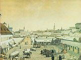
Wooden bridge between the Linz main square and the “Platzl” in Urfahr around 1830.

Wooden bridge with rails around 1857. View from Urfahr to Linz
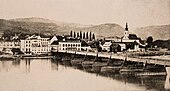
Side view with a view of Urfahr (around 1860)

Iron Bridge in 1910
.png)


Wish for a bigger bridge
The young Adolf Hitler , who grew up in Leonding and occasionally attended school in Linz , also joined the desire for a new bridge . Sketches that have been preserved show that Hitler had specific ideas about a new bridge as early as 1925. After the so-called Anschluss in March 1938, Hitler took over the "sponsorship" of the city and named Linz one of the leaders' cities with the aim of developing the city into an economic and cultural center. These plans envisaged far-reaching reconstruction measures which, in addition to redesigning the banks of the Danube, included the establishment of a so-called “cultural axis”. From 1938 onwards, only small parts of these plans - for example only the two southern and not the northern bridgehead buildings - were implemented; the extensive incorporations in the north and south as well as the associated housing measures were carried out.
Construction of the Nibelungen Bridge
In the course of the National Socialist expansion plans for the “ Führerstadt Linz ”, the engineer Karl Schaechterle and the architect Friedrich Tamms were commissioned to plan a new bridge over the Danube in place of the old one; the construction management went to Werner Sarlay from Linz. The bridge design, a solid girder bridge with three openings and spans of 75 meters at the edge fields and 100 meters at the central opening, was approved in the summer of 1938. Construction work began in September of the same year; In 1940 the bridge was ready.
The exact origin of the name "Nibelungenbrücke" can no longer be clearly clarified; according to contemporary sources there is only the indication that the name goes back to the unspecified "fathers of the bridge". It refers to the myth of the “ Nibelungenweg ”, on which the Germanic legendary figures Kriemhild and her brothers are said to have touched the area of today's Linz on their way to the Hun King Etzel . Further reference to the Nibelung saga was to be created by four equestrian statues of the most important Nibelung figures ("Siegfried", "Kriemhild", "Gunter" and "Brunhild"), six and a half meters high . Two more statues, "Hagen" and "Volker", were to adorn the bridge stairs in Urfahr. Due to the war, the statues commissioned by Hitler from the sculptor Bernhard Graf Plettenberg were not executed. On the occasion of a visit by the Führer, two of the statues (“Kriemhild” and “Siegfried”) were modeled in plaster by Plettenberg on a 1: 1 scale and placed on the bridge for a few months.
Simultaneously with the construction of the Nibelungen Bridge, some buildings on both banks of the Danube were demolished to make room for the wider and higher bridge. On the main square in Linz, which is directly adjacent to the Nibelungen Bridge , several historicist buildings were demolished in order to be replaced by the "bridgehead buildings" that still exist today . The two structurally identical buildings house parts of the Linz Art University on the one hand and the Linz tax office until May 2008 on the other. On the Urfahraner side, the bridgehead buildings could no longer be realized. This later made the construction of the New Town Hall and the Ars Electronica Center possible .
post war period

In the course of the handover of the Mühlviertel to the Soviets , American troops left Urfahr on July 31, 1945. Until June 8, 1953, there were constant controls of the passenger and freight traffic at the new Soviet zone border at the Urfahraner bridgehead. After that only periodic. The Linz population spontaneously celebrated the lifting of the permanent controls. Governor Heinrich Gleißner danced a waltz with Elmira Koref , wife of the Linz mayor Ernst Koref . On August 11, 1955, the Mühlviertel returned to Upper Austrian administration, which meant that the division of the city was also canceled.
Others
.png)
On November 9, 1962, the Austrian Post issued a definitive stamp from the Austrian Architectural Monuments series of stamps worth 2.50 Schilling for this motif .
Neighboring bridges
Above on the Danube through the Rollfähre Second cable bridge Ottensheim chargeable open for passenger cars, more above the power plant Ottensheim that bridges the Danube for cycling, and the Donaubrücke Aschach .
Downstream, the successor bridge for the railway bridge that was demolished in 2016 will be built by 2020 . This is followed by the VÖEST bridge (motorway requiring a vignette plus mixed cycle and sidewalks) and the two Steyregger bridges for Donau Straße B3 (separate lanes, one walkway and cycle path on both sides, but only without direct connection to the cycle route on the left bank of the Danube on the B3 and L569 to the left of the collecting channel for the Mühlviertel brooks) or Summerauer Bahn and the Abzüge-Asten power plant, which is open all year round for pedestrians and cyclists .
Construction of the fourth Linz Danube Bridge for motor vehicle traffic in the area west of the Römerberg Tunnel as part of the Linz A 26 motorway (with tunnel) began in January 2019 and is scheduled to be completed in 2023.
Somewhat downstream of the Pleschinger See , the Linz Danube culvert has crossed the bed of the Danube with pipes for drinking water and sewage since 1978.
Individual evidence
- ^ List of bridges across the Danube. ( Memento of August 11, 2013 in the Internet Archive ) (PDF; 84 kB) viadonau
- ^ Christian Rohr : Extreme natural events in the Eastern Alps: Experience of nature in the late Middle Ages and at the beginning of the modern era. Volume 4 of Environmental Historical Research . Verlag Köln, Weimar 2007, ISBN 978-3-412-20042-8 , p. 205 f ( limited preview in the Google book search)
- ↑ Struggle for bridges over the Danube. Article by Roman Sandgruber from November 20, 2010 on nachrichten.at
- ^ Fritz Mayrhofer: The "Godfather City of the Führer", dreams and reality . In: Fritz Mayrhofer, Walter Schuster (eds.): National Socialism in Linz ; 2nd edition, Linz 2002, ISBN 3-900388-81-4 , pp. 327–386, here pp. 328–329, 333–337.
- ↑ UfA: Wochenschau from March 27, 1940, (Tonwoche 499, minute 2:00 to 2:40): "5,200 tons of steel", "200,000 rivets"; Video on archive.org, accessed December 8, 2016.
- ↑ Linzer Volksblatt of May 8, 1939; Daily mail from May 9, 1939.
- ↑ Carl Peter Fröhling: The sculptor Bernhard Graf von Plettenberg zu Lenhausen and Hitler's dream of the Nibelungen Bridge in Linz on the Danube. In: Voices from the Olpe district. Jg. 1976, pp. 189-195, ISSN 0177-2899 .
- ^ Roman Sandgruber: Hitler's "Capital of Culture" in the forum OoeGeschichte.at
- ↑ Rudolf Lehr : State Chronicle of Upper Austria. Christian Brandstätter Verlag, Vienna 2008, ISBN 978-3-85498-331-6 , p. 378.
-
^ Chronicle of the year 1953 , Land Upper Austria: Landesgeschichte , accessed on July 11, 2009;
Upper Austrian news of June 10, 1953, p. 1. - ↑ State history of Upper Austria. P. 384.
- ^ Railway bridge: The course for new construction has been set. City of Linz Magistrate ( http://www.linz.at/presse/ ), September 2015, accessed on September 30, 2015 .
- ↑ mein district.at: Asten / Abhaben power plant open to pedestrians and cyclists all year round , article from January 5, 2018, accessed on July 22, 2018
Web links
Coordinates: 48 ° 18 ′ 27 ″ N , 14 ° 17 ′ 5 ″ E