Mauterner bridge
Coordinates: 48 ° 23 ′ 51 ″ N , 15 ° 34 ′ 30 ″ E
|
|
||
|---|---|---|
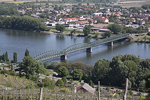
| Mauterner Bridge, seen from the left, northern bank | ||
| use | Road, bicycle and pedestrian bridges | |
| Convicted | Aggsteiner Strasse (B33a) | |
| Crossing of |
Donau Strasse Donau Aggsteiner Strasse |
|
| place | Krems and Mautern on the Danube | |
| overall length | 374 m | |
| width | 11 m | |
| start of building | 1893 | |
| opening | 1895 | |
| planner | Factory Ig. Gridl | |
| location | ||
|
|
||
The Mauterner Brücke , formerly called Stein-Mauterner Brücke , is a bridge over the Danube between Stein , the district of Krems an der Donau , which was incorporated in 1938 , and Mautern an der Donau in Lower Austria . The Aggsteiner Straße B33a leads over it .
Its forerunner was the second Danube bridge in Austria .
history
prehistory
According to finds, the transition between Mautern and Stein was used regularly from 100 AD. A transition to a market north of the Danube is also described in the biography of Saint Severin . While the Mautern Castle, which was owned by Passau, secured the south bank, the Förthof , originally called Urfahr , was located on the north bank for this purpose .
Wooden Joch Bridge (1463)
On June 17, 1463 Stein and Krems had from Emperor Friedrich III. received a bridge privilege, the second after Vienna was allowed to build the first Danube bridge in all of Austria in 1439. The privilege determined that the bridge from Mautern should be preserved and half of the toll income should be given to the ruler, who also had the right to appoint the bridge master.
The southern end of the wooden Jochbrücke was close to today's bridge in Mautern, the northern end was in stone at the Linzer Tor, where a mosaic plaque indicates the exact location. According to the description by Martin Zeiller published in 1679 , it had 33 or 34 bays and was said to have been 800 paces long, which seems a bit exaggerated, even if it reached over the now built-up bank zone to the historic Mautern. Since it was repeatedly damaged by floods and ice , the bridge maintenance department always had to keep wood for eight yokes and nine bridge fields in stock, which was delivered by rafts . After repairs, the waste wood was auctioned to the highest bidder.
From 1876 the bridge was illuminated with 8 lanterns - less for the bridge users than to warn shipping.
When chain shipping was introduced on the route to Linz after 1881 and the barges got bigger, there was soon an accident at the narrow bridge passage. The Donau-Dampfschiffahrts-Gesellschaft then had a wider iron bridge field installed around 1885.
When the new bridge was completed in 1895, the old bridge was auctioned by the DDSG and removed. The iron bridge field was lowered onto two barges and swam away. Finally, the stakes were also pulled.
Steel truss bridge (1895)
In 1893 the construction of the Kaiser-Franz-Joseph-Brücke began with the award of the contract for the substructures and ramps to E. Gaertner, who had just completed the corresponding work for part of the Danube bridge in Cernavodă in Romania and his construction equipment to Mautern got. The foundations of the three river pillars were also placed here with iron caissons .
The four semi-parabolic girders of the superstructure were made by the renowned Viennese companies R. Ph. Waagner and Fabrik Ig. Gridl created. The shorter beam above the northern bank area came from the bridge building company of the First Bohemian-Moravian Machine Factory. The girders were not made from wrought iron , as was customary until recently , but from Siemens-Martin steel . The concrete roadway was paved with wooden sticks, which were replaced by asphalt over time.
The bridge was officially opened on May 18, 1895.
The great importance of this bridge was demonstrated by the fact that around 34,000 soldiers were supposed to defend the Krems bridgehead during the First World War and bunkers were built within a radius of 5 kilometers. Due to the enormous expansion of the war, however, neither enough people nor material were available. Therefore, from the summer of 1915 , the kuk army command decreed a reduction in expansion work and, on May 1, 1916, the liquidation of the bridgehead command.
Towards the end of the Second World War , the bridge was partially blown up by the Wehrmacht on May 8, 1945 in order not to fall into Soviet captivity. After the end of the war, the two southern bridges were rebuilt by German prisoners of war under Soviet supervision with Roth-Waagner bridge equipment stored in Krems and reopened on September 30, 1945 by Soviet Marshal Ivan Stepanowitsch Konew and State Chancellor Karl Renner .
description
The bridge still consists of its two historical parts: the two semi-parabolic girders completed in 1895 with the beam girder over the northern bank area and the two southern bridge fields bridged in 1945 with Roth-Waagner bridge equipment. The Roth Waagner girders are clearly recognizable by their parallel - belt framework and the many screw connections.
The bridge is 374 m long and 11 m wide, including the sidewalks and bike paths installed outside. The semi-parabolic girders and the Roth-Waagner girders are each 82.5 m, the beam girder is 42 m long; they are not directly related to each other.
Like the bridge keeper's house to the northeast, the bridge is a listed building.
The road structure was renovated in 2013. In the course of the heat wave of the same year, the bridge had to be closed again due to the heat damage. A bridge girder had slipped from its camp.
In July 2014, there was a lot of thought about demolishing the bridge, even though it is a listed building. Raising the bridge and strengthening the sweep is currently being considered and calculated. In August 2018 it was announced that more detailed investigations will probably require a further reduction of the weight limit from 16 t to 9 t.
literature
- Karl Reder: The reconstruction of the Danube bridge Stein-Mautern , in: Karl Reder (Ed.), Manfred Schovanec: Contributions to the city history of Mautern on the Danube 1918–1955 , (Mautern) 2015, pp. 369–386, ISBN 978-3 -200-04023-6
Web links
- Certificate of bridge privilege. Documents Krems (1108-1844) StaAKr-0399 in: monasterium.net
Individual evidence
- ^ Rupert Schweiger: The magic of architecture - twin cities Krems-Stein and Mautern. , Niederösterreichisches Pressehaus, St. Pölten 1993 ISBN 3 85326 956 7 , p. 269
- ↑ a b c d Josef Hadrbolec: The History of the Mauterner Danube Bridge Bridge Lecture on June 17, 2013 at the Museum Association Krems (PDF; 6.2 MB)
- ^ Roman Sandgruber: Wrestling about Danube bridges Article from November 20, 2010 in OÖNachrichten
- ↑ a b c Josef Hadrbolec: What connects the Stein-Mauterner road bridge with the Schönbrunn palm house? In: Monument Protection Initiative, No. 18, 2014, p. 16 (PDF; 5.4 MB)
- ↑ Niederösterreich Nachrichten: Bridgehead: theater of war that never fought ; accessed on Aug. 21, 2014
- ↑ Mauterner Danube Bridge - half imperial, half Soviet! Monika Hauleitner's blog from April 23, 2016 on kremskultur.at
- ↑ The frequently mentioned length of 435 m includes the modern bridge over Aggsteiner Strasse in front of the roundabout in Mautern, separated by a short dam.
- ↑ Dimensions from Google Earth
- ^ Lower Austria - immovable and archaeological monuments under monument protection. ( Memento from June 1, 2016 in the Internet Archive ) . Federal Monuments Office , as of June 6, 2012 (PDF).
- ↑ Heat: Mauterner Danube bridge sinks on ORF from August 7, 2013, accessed on August 8, 2013.
- ↑ ORF Lower Austria, accessed on July 31, 2014
- ↑ Krems, Mautern - Fix: Danube bridge is being raised
- ↑ Soon the 9-ton limit on Mauterner Bridge. Article from August 21, 2018 in NÖN.at


