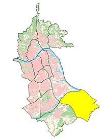
Pichling (Linz)
| Linz district of Pichling | |
|---|---|
| Basic data | |
| political district | Linz (L) |
| surface | 12.9 km² |
| Residents | 8183 (as of 2019) 634 inhabitants per km² |
Pichling is a district of Linz south of the Traun .
Geography and history
Pichling borders in the southwest on Ebelsberg , in the northwest on industrial area harbor and in the west, in a short section, also on Kleinmünchen-Auwiesen . Adjacent communities are Sankt Florian in the south, Asten in the southeast , Luftenberg in the east and Steyregg in the north .
The place name goes back to the field name , which is first attested in writing in 1222 as Puhel (in Middle High German bühel hill). The settlement there was identified by adding the -ing suffix , which is the name of Pichling Siedlung am Hügel .
The district was created on January 1st, 2014. The area previously belonged to the Ebelsberg district.
Waters
The district is bordered in the north and northwest by the Traun and in the east by the Danube. In the north, near the mouth of the Traun into the Danube, there are the Große and Kleine Weikerlsee lakes , and in the south the Pichlinger See .
Infrastructure
In the north, near the Weikerlseen, is the Solar City development designed on the drawing board .
Buildings
See also : List of works of art in public space in Linz-Pichling
Web links
Individual evidence
- ↑ a b Linz - Politics / Administration - Linz Figures - City Area (with an overview of the current and former statistical districts of Linz valid from 1957 to 2013), data as of January 1, 2019; accessed on December 29, 2019
- ↑ doris.at (neighboring communities)
- ↑ linz.at: solarCity Pichling - Das Projekt , accessed on December 29, 2019
Coordinates: 48 ° 14 ′ 29 ″ N , 14 ° 22 ′ 14 ″ E


