
Goldwörth
|
Goldwörth
|
||
|---|---|---|
| coat of arms | Austria map | |
 |
|
|
| Basic data | ||
| Country: | Austria | |
| State : | Upper Austria | |
| Political District : | Urfahr environment | |
| License plate : | UU | |
| Surface: | 10.82 km² | |
| Coordinates : | 48 ° 21 ' N , 14 ° 6' E | |
| Height : | 262 m above sea level A. | |
| Residents : | 813 (January 1, 2020) | |
| Population density : | 75 inhabitants per km² | |
| Postal code : | 4102 | |
| Area code : | 0 72 34 | |
| Community code : | 4 16 08 | |
| NUTS region | AT312 | |
| Address of the municipal administration: |
Schulstrasse 1 4102 Goldwörth |
|
| Website: | ||
| politics | ||
| Mayor : | Johann Müllner ( ÖVP ) | |
|
Municipal Council : (2015) (13 members) |
||
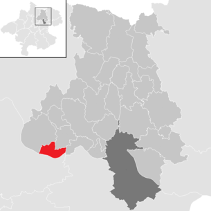
| Location of Goldwörth in the Urfahr-Umgebung district | ||
  |
||
| Source: Municipal data from Statistics Austria | ||

Goldwörth is a municipality in Upper Austria in the Urfahr-Umgebung district in the upper Mühlviertel with 813 inhabitants (as of January 1, 2020). The community is located in the judicial district of Urfahr .
geography
Goldwörth lies at an altitude of 262 m above sea level. A. in the upper Mühlviertel or in the nature conservation area Eferdinger Basin . The extension is from north to south 3.5 km and from west to east 5.6 km. The total area is 10.8 km, with 56.3% being used for agriculture. 25% of the municipal area is accounted for by forest, developed and undeveloped building land comprises around 4% of the municipal area. Districts are Goldwörth and Hagenau.
Area distribution

The municipality includes the following localities (population in brackets as of January 1, 2020):
- Goldworth (776)
- Haguenau (37)
Neighboring communities
| Feldkirchen on the Danube | Walding | |
.svg)
|
Ottensheim | |
| alcove |
Geology and soils
The subsoil of the municipality of Goldwörth is shaped by the characteristics of the northern Eferdinger Basin. Their levels are made up of 15 to 20 meters thick, Wurm-Ice Age gravel-sand bodies (aquifers), which are layered over the sand, interlocking, tertiary streaks (groundwater reservoirs).
Landscape and vegetation
In terms of landscape, the municipality can be roughly divided into four natural areas. In the south, alluvial forests extend along the Danube , which are dominated by hybrid poplars as well as the bastard black poplar and the common ash . In addition, there are individual agricultural areas with arable farming and extensively farmed meadows. In addition to the Danube in the south, there is also an artificial flood relief channel that flows into the Pesenbach and a regatta course. To the north of the alluvial forest there is an agricultural landscape of the Austufe, which is characterized by arable farming and is only sparsely forested. There are also meadow areas with fruit trees or orchards. Within the agricultural landscape lie the settlement areas of Goldwörth and Hagenau, whereby the two places are rural places with a mixed development structure. In the settlement areas there are also extensive orchards, which, however, are often dedicated as building land. The fourth sub-area is the river landscape with wood on the banks of the Pesenbach or the relief channel with near-natural alluvial forests. The common ash , black alder , willow, English oak and sycamore maple are mainly found here .
Community structure
| District | 2001 | 2011 |
|---|---|---|
| Goldwörth | 765 | 818 |
| Haguenau | 105 | 112 |
The municipality of Goldwörth is congruent with the cadastral municipality of Goldwörth. In 2011 around 88 percent of the community's residents lived in the village of Goldwörth, which in 2001 comprised 231 buildings, 24 workplaces and 58 agricultural and forestry businesses. The Pfeiffer settlement and the hamlet of Rutzingerdorf were also included in Goldwörth . The scattered settlement of Hagenau comprised 34 buildings, three workplaces and 10 agricultural and forestry businesses. The Rotte Waldinger level belongs to Hagenau.
history
Originally located in the eastern part of the Duchy of Bavaria, Goldwörth was first mentioned in a document in 1067 as Goldawerd . The name comes from the Middle High German golder and (gold panners) value back (river island). A nearby Danube island bore the name (1220: insula Golderwerde ). The field name was transferred to the settlement. Perhaps the place itself was on an island back then because the Danube was not yet regulated.
The place has belonged to the Duchy of Austria since the 12th century and was added to the Principality of Austria ob der Enns from 1490 . In the 13th and 14th centuries, the place belonged to Alkoven, the administration of Goldwörth is originally from Ebelsberg , from 1731 by Eschelberg . During the Napoleonic Wars , the place was occupied several times and has since returned to Upper Austria. From 1875 Goldwörth formed a municipality together with Walding, and in 1880 Goldwörth became an independent municipality. After Austria was annexed to the German Reich on March 13, 1938, Upper Austria became the Gau Oberdonau . In 1945 Upper Austria was restored, from 1945 to 1955 Goldwörth was part of the Soviet zone of occupation .
population
Population structure
In 2017, 850 people lived in the Goldwörth community, making Goldwörth the second smallest of the district's 27 communities. In terms of population density, Goldwörth had the eighth lowest population density in the district with 79 inhabitants per km². In 2016, 97.9 percent of the population were Austrian citizens (Upper Austria 88.2 percent), Urfahr-Umgebung district 95.1 percent In total, only 18 foreigners were counted in the municipality in 2016. In 2001, 92.1 percent of the population committed to the Roman Catholic Church (Upper Austria: 79.4 percent), 5.5 percent were without confession and 0.3 percent were Protestants.
The average age of the community population in 2016 was below the national average. 23.3 percent of the residents of Goldwörth were younger than 20 years (Upper Austria: 17.2 percent), 63.0 percent between 20 and 64 years old (Upper Austria: 66.6 percent). The proportion of residents over 64 years of age was 13.8 percent, below the national average of 16.2 percent. According to their marital status, 31.1 percent of the residents of Goldwörth were single over the age of 14 in 2015, 58.6 percent were married, 4.8 percent widowed and 5.5 percent divorced.
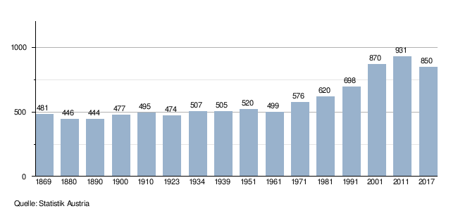
Population development
Up until the early 1960s, the municipality of Goldwörth experienced below-average population growth compared to the federal state of Upper Austria, with the number of inhabitants rising by only 4 percent from 481 to 499 during this period. The population growth was roughly analogous to the district area. Between 1961 and 2011, the population increased from 499 to 930 people, increasing the population by 86 percent during this time. After that, the number of inhabitants fell by 9 percent between 2011 and 2017, which is mainly due to the settlement of large parts of Hagenau after the floods in 2013.
politics
Municipal council
The municipal council as the highest body of the municipality has 13 seats and is elected every six years in the course of Upper Austria-wide municipal council elections. The municipality board consists of three members, with the Austrian People's Party (ÖVP) being represented by the mayor and the vice-mayor on the municipal board after the 2015 municipal council elections and thus having an absolute majority on this body. The Social Democratic Party of Austria (SPÖ) sends a member to the community council.
The ÖVP is traditionally the strongest party in local council elections in Goldwörth. In the elections since 1973 it always achieved an absolute majority of votes and mandates, whereby in 1991 and since 2009 it also achieved a two-thirds majority. The second strongest party is the SPÖ, which took second place in local council elections. No other parties have competed in Goldwörth since the 1970s.
| Political party | 2015 | 2009 | 2003 | 1997 | 1991 | 1985 | 1979 | 1973 | ||||||||
|---|---|---|---|---|---|---|---|---|---|---|---|---|---|---|---|---|
| percent | Mandates | percent | Mandates | percent | Mandates | percent | Mandates | percent | Mandates | percent | Mandates | percent | Mandates | percent | Mandates | |
| ÖVP | 67.5 | 9 | 70.0 | 9 | 62.2 | 8th | 64.0 | 8th | 67.3 | 9 | 63.7 | 8th | 64.1 | 8th | 63.5 | 8th |
| SPÖ | 32.5 | 4th | 30.0 | 4th | 37.8 | 5 | 36.0 | 5 | 32.7 | 4th | 36.3 | 5 | 25.9 | 5 | 36.5 | 5 |
mayor
The mayor has been determined by direct election since 1997 , with no absolute majority for a candidate in a runoff election . Helmut Ausserwöger (ÖVP) won the first direct mayor election with 83 percent in the first ballot against his SPÖ challenger. In 2003 the current mayor, Johann Müller, succeeded Ausserwöger. He was able to achieve 81 percent of the valid votes in the 2003 election, his SPÖ opponent candidate got 19 percent. Müller was confirmed in the 2009 and 2015 elections with 93 percent and 91 percent respectively, with no opposing candidates.
Mayor since 1850:
| Term of office | Surname | Term of office | Surname |
|---|---|---|---|
| 1850-1855 | Michael Leithner | 1946-1955 | Leopold Eisner |
| 1855-1864 | Mathias worms | 1955-1967 | Ruper worms |
| 1864-1867 | Johann Lugmair | 1967-1979 | Hermann Fellner |
| 1867-1870 | Mathias Hellmeier | 1979-1990 | Rudolf Gumplmayr |
| 1870-1873 | Michael Bergmair | 1990-2003 | Helmut Ausserwöger |
| 1873-1881 | Johann Lugmair | 2007– | Johann Müller |
| 1881-1919 | Simon Leitner | ||
| 1919-1924 | Ferdinand Rechberger | ||
| 1924-1929 | Johann Steineder | ||
| 1929-1932 | Mathias Hellmayr | ||
| 1932-1933 | Johann Kirchmayr | ||
| 1933-1942 | Johann Huemer | ||
| 1942-1945 | Johann Kirchmayr | ||
| 1945-1946 | Leopold Weinzierl |
Other options
As in municipal council elections, the ÖVP also dominates regional elections in the municipality, although the dominance of the People's Party has recently declined sharply. Nevertheless, the ÖVP has always been able to become the party with the strongest vote since 1973, and before 2009 it also had an absolute majority. The ÖVP achieved its strongest result since the 1970s in 1979 with 66.8 percent of the vote. In the state elections in 2015, the ÖVP fell from 56.6 percent to 30.9 percent. The second strongest party was the SPÖ until 2015. It achieved around a third of the votes cast in the elections, with 34.8 percent in 1973, its strongest election result since the 1970s. After heavy losses in the 2009 elections, the SPÖ in Goldwöth had to accept further losses in 2015 and achieved its worst result to date with 18.9 percent. The FPÖ only achieved single-digit results in state elections in Goldwörth until 1991. After that, the results fluctuated between 4 and 12 percent. In the last election, the FPÖ almost tripled its result to 27.0 percent. The Greens have achieved election results in Goldwörth over 9 percent since 2003, most recently they were able to increase to 14.1 percent.
Economy and Infrastructure
Workplaces and employees
In 2016, Goldwörth housed a total of 66 workplaces with 174 employees, 113 of which were employed. The largest number of workplaces was in agriculture and forestry with 23, with 35 employees (20 percent of all employees) being counted in this area. The second strongest branch was trade with 17 workplaces and 55 employees (32 percent of all employees). Other important sectors were professional and technical services (7 workplaces with 10 employees), public administration (one workplace with 14 employees) and construction (three workplaces with 23 employees). 40 percent of the employees in Goldwörth were employees or civil servants, 25 percent blue-collar workers and 32 percent self-employed.
Agriculture and Forestry
In 2010 the statistics showed 26 agricultural and forestry holdings for the municipality of Goldwörth. These included 9 full-time businesses and 17 part-time businesses. Compared to 1999, the total number of establishments had fallen by 21 establishments or 47 percent, the decline only affecting part-time businesses. In 2010, the farms farmed a total of 460 hectares, with 43 percent of the area being farmed by full-time farmers and 57 percent by part-time farmers. The average area of full-time farmers was 21.8 hectares, well below the Upper Austrian average of 33.8 hectares.
Culture and sights
Attractions

Goldwörth emerged as a church hamlet, which was expanded into a street group village in the first half of the 20th century. The parish church , together with the parsonage and the cemetery wall in the southwest, form a small monument complex, with the parish church and parsonage being a listed building. The parish church dates from the first third of the 16th century and was possibly built using older outer walls. Built in the late Gothic style, the interior was decorated in a neo-Gothic style. The rectory was built in 1783 and 1874 as a late baroque Streckhof. In the village of Goldwörth there are farms of various forms, in particular mighty square and three and four-sided farms. The few remaining historical buildings date from the Baroque or 19th century. Most of the chapels in the local area also date from the 19th century. The Haslinger Chapel in Käferbachstrasse was built in 1870, the neo-Gothic Schöppl Chapel in Schulstrasse around 1850. In Schulstrasse, there is another chapel from around 1870, the Laher Chapel, the Hubertus Chapel on Hühnersteiggraben with deer antlers from the Kaiservilla Bad Ischl, on the other hand, was built in 1961.
- see also: List of listed objects in Goldwörth
freetime and sports
Outdoor swimming pool, tennis court, table tennis hall, asphalt track, ice stock rink, fishing ponds, mini steam train, well-marked hiking trails, cycle paths, mountain bike trails,
- in winter: ice skating and sledding on Monte Goldi, curling rink
Personalities
- Josef Karl Mayr (1900–1979), civil servant and agricultural specialist born in Goldwörth, chamber office director of the Upper Austrian Chamber of Agriculture
Web links
- 41608 - Goldwörth. Community data, Statistics Austria .
Further information about the municipality of Goldwörth can be found on the geographic information system of the federal state of Upper Austria .
Individual evidence
- ↑ a b c natural space mapping Upper Austria. Landscape survey of the community of Goldwörth. Final report. Kirchdorf an der Krems 2004
- ↑ Statistics Austria: Population on January 1st, 2020 by locality (area status on January 1st, 2020) , ( CSV )
- ↑ Classification according to Statistics Austria
- ^ Statistics Austria (ed.): Ortverzeichnis 2001. Oberösterreich. Vienna 2005
- ^ Ernst Schwarz: The place names of eastern Upper Austria (= Pr. German studies ). Kraus Verlag, Reichenberg, p. 88 .
-
↑ a b State of Upper Austria population level in the Urfahr-Umgebung district in 2016;
State of Upper Austria population in Goldwörth 2016. - ↑ Statistics Austria: Population by religion and federal states 1951 to 2001 (accessed on October 2, 2013)
- ↑ a b Statistics Austria community data from Goldwörth
- ↑ Upper Austrian News "Grass is slowly growing over a small village"
- ^ Province of Upper Austria election results in mayoral elections
- ↑ State of Upper Austria mayor since 1850.
- ^ Province of Upper Austria State election results in Goldwörth from 1973.
- ↑ Statistics Austria register census from October 31, 2011 Workplaces and employees according to sections of ÖNACE 2008 and job status
- ↑ Peter Adam, Beate Auer and others: Dehio-Handbuch Oberösterreich. Volume 1: Mühlviertel. Berger Verlag, Horn / Vienna 2003, ISBN 3-85028-362-3 , pp. 202-206.

Alberndorf in the Riedmark | Altenberg near Linz | Bad Leonfelden | Eidenberg | Engerwitzdorf | Feldkirchen an der Donau | Gallneukirchen | Goldwörth | Gramastetten | Haibach im Mühlkreis | Hellmonsödt | Herzogsdorf | Kirchschlag near Linz | Lichtenberg | Oberneukirchen | Ottenschlag in the Mühlkreis | Ottensheim | Puchenau | Reichenau im Mühlkreis | Reichenthal | Schenkenfelden | Sonnberg in the Mühlkreis | St. Gotthard in the Mühlkreis | Steyregg | Vorderweißbach | Walding | Zwettl on the Rodl