
St. Gotthard in the Mühlkreis
|
St. Gotthard in the Mühlkreis
|
||
|---|---|---|
| coat of arms | Austria map | |
 |
|
|
| Basic data | ||
| Country: | Austria | |
| State : | Upper Austria | |
| Political District : | Urfahr environment | |
| License plate : | UU | |
| Main town : | Rottenegg | |
| Surface: | 12.07 km² | |
| Coordinates : | 48 ° 23 ' N , 14 ° 8' E | |
| Height : | 473 m above sea level A. | |
| Residents : | 1,304 (January 1, 2020) | |
| Population density : | 108 inhabitants per km² | |
| Postal code : | 4112 | |
| Area code : | 07234 | |
| Community code : | 4 16 21 | |
| NUTS region | AT312 | |
| Address of the municipal administration: |
Rottenegger Strasse 17 4112 St. Gotthard im Mühlkreis |
|
| Website: | ||
| politics | ||
| Mayor : | Johannes Rechberger ( ÖVP ) | |
|
Municipal Council : (2015) (19 members) |
||
| Location of St. Gotthard in the Mühlkreis in the Urfahr-Umgebung district | ||
  |
||
| Source: Municipal data from Statistics Austria | ||

St. Gotthard im Mühlkreis is a municipality in the Upper Mühlviertel in the Urfahr-Umgebung district in Upper Austria with 1304 inhabitants (as of January 1, 2020). The community is located in the judicial district of Urfahr .
geography
St. Gotthard in the Mühlkreis lies at an altitude of 473 m above sea level. A. in the Upper Mühlviertel . The extension is 5.0 km from north to south and 5.0 km from west to east. The total area is 12 km². The highest point of the municipality is 517 m above sea level. A. in the village of Grasbach, the lowest at 276 m in Rottenegg.
The municipality includes the following localities (population in brackets as of January 1, 2020):
- Eschelberg (195)
- Grasbach (82)
- Haselwies (80)
- Maierleiten (50)
- Millwood (10)
- Oberstrasse (140)
- Rottenegg (452)
- St. Gotthard im Mühlkreis (295)
The municipal office and the kindergarten are located in Rottenegg. The more than 200 m higher St. Gotthard houses next to the late Baroque parish church of the parsonage and the elementary school. The Rottenegg station on the Mühlkreisbahn is in the municipality of Walding .
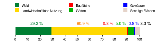
Area distribution
Neighboring communities
| Herzogsdorf | ||
| Feldkirchen on the Danube |
.svg)
|
Gramastetten |
| Walding |
history
As a stone ax find near the parish church shows, the municipality of St. Gotthard was already settled in the Stone Age. From the Middle Ages to the 19th century, the area benefited economically due to its location on the Krumau Reichsstraße , a section of the Via Regia between Linz and Bohemia, first mentioned in 1142 . The lively trade led to the construction of the castles Eschelberg (before 1205) and Rottenegg (before 1285).
In 1558 the place name was first mentioned in a document when a certain "Hannß von Sanndt Gothart" was mentioned.
In the 17th century, a chapel dedicated to St. Godehard was built on the site of today's parish church , which was redesigned in 1711 by Count Gundacker von Starhemberg into a church in the late Baroque style.
Originally located in the eastern part of the Duchy of Bavaria , the place belonged to the Duchy of Austria since the 12th century . From 1490 onwards it was assigned to the Principality of Austria ob der Enns .
During the Napoleonic Wars , the place was occupied several times.
After St. Gotthard had been administered jointly with Herzogsdorf and Stamering from 1875 , it was re-established as a separate municipality in 1888 based on a petition from the Upper Austrian state parliament . In 1951, the northern part of the village of Grasbach was incorporated and the community was renamed from St. Gotthard to St. Gotthard in the Mühlkreis .
Population development

The strong growth from 1981 to 2001 took place because both the birth balance and the migration balance were positive. From 2001 to 2011, emigration canceled out the positive birth rate.
coat of arms
Blazon : split from red and gold by a pole that is split from silver and red and covered with a straight-armed paw cross in alternating colors; on both sides a pinnacle tower on green rocks, on the right a silver one, on the left a red one, with two openwork windows one above the other.
The community colors are white-green.
politics
Mayor is Johannes Rechberger ( ÖVP ). The municipal council has 19 members (9 ÖVP , 7 SPÖ , 3 FPÖ ).
Attractions


- Parish Church of St. Gotthard: late baroque mountain church, in 1835 it received its present shape with the characteristic onion dome .
- Eschelberg Castle : castle complex extended to a renaissance castle
- Rottenegg castle ruins : ruins of a medieval castle complex that was converted into a castle at the end of the 16th century
- See also: List of listed objects in St. Gotthard im Mühlkreis
Personalities
- Leopold Hager (1889–1972), provost of St. Florian Monastery
- Leopold Wurzinger (1921–2011), Judge and President of the Supreme Court
- Felix Luckeneder (* 1994), soccer player
Web links
- 41621 - St. Gotthard in the Mühlkreis. Community data, Statistics Austria .
- More information about the municipality of St. Gotthard in the Mühlkreis on the geo-information system of the federal state of Upper Austria .
- Map in the Digital Upper Austrian Room Information System ( DORIS )
- Literature on Sankt Gotthard in the forum OoeGeschichte.at
Individual evidence
- ↑ Statistics Austria: Population on January 1st, 2020 by locality (area status on January 1st, 2020) , ( CSV )
- ↑ a b Community of St. Gotthard in the Mühlkreis: Description of the place. Retrieved May 10, 2016 .
- ↑ Karl Hohensinner and Peter Wiesinger : Place Name Book of the Province of Upper Austria 10. The place names of the political district Urfahr-Umgebung (Middle Mühlviertel). Vienna 2006
- ↑ 42. Announcement of the Upper Austrian state government of October 8, 1951
- ^ Statistics Austria, A look at the community of St. Gotthard in the Mühlkreis, population development. Retrieved May 4, 2019 .
- ^ State of Upper Austria, history and geography, coat of arms. Retrieved May 4, 2019 .
- ↑ Municipal Council. In: www.webwahl.net. Retrieved November 23, 2015 .
- ↑ "I enjoy every second of LASK" . In: mein district.at . ( mein district.at [accessed on November 10, 2018]).

Alberndorf in the Riedmark | Altenberg near Linz | Bad Leonfelden | Eidenberg | Engerwitzdorf | Feldkirchen an der Donau | Gallneukirchen | Goldwörth | Gramastetten | Haibach im Mühlkreis | Hellmonsödt | Herzogsdorf | Kirchschlag near Linz | Lichtenberg | Oberneukirchen | Ottenschlag in the Mühlkreis | Ottensheim | Puchenau | Reichenau im Mühlkreis | Reichenthal | Schenkenfelden | Sonnberg in the Mühlkreis | St. Gotthard in the Mühlkreis | Steyregg | Vorderweißbach | Walding | Zwettl on the Rodl