
Altenberg near Linz
|
market community Altenberg near Linz
|
||
|---|---|---|
| coat of arms | Austria map | |
 |
|
|
| Basic data | ||
| Country: | Austria | |
| State : | Upper Austria | |
| Political District : | Urfahr environment | |
| License plate : | UU | |
| Surface: | 36.32 km² | |
| Coordinates : | 48 ° 22 ' N , 14 ° 21' E | |
| Height : | 592 m above sea level A. | |
| Residents : | 4,672 (Jan 1, 2020) | |
| Population density : | 129 inhabitants per km² | |
| Postal code : | 4203 | |
| Area code : | 0 72 30 | |
| Community code : | 4 16 02 | |
| NUTS region | AT312 | |
| UN / LOCODE | AT AGZ | |
| Address of the municipal administration: |
Reichenauer Strasse 4 4203 Altenberg near Linz |
|
| Website: | ||
| politics | ||
| Mayor : | Ferdinand Kaineder ( ÖVP ) | |
|
Municipal Council : (2015) (25 members) |
||
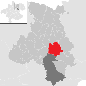
| Location of Altenberg near Linz in the Urfahr-Umgebung district | ||
  |
||
| Source: Municipal data from Statistics Austria | ||


Altenberg bei Linz ( ) is a market town in Upper Austria in the Urfahr-Umgebung district in the upper Mühlviertel with 4672 inhabitants (as of January 1, 2020). The community is located in the judicial district of Urfahr .
geography
Altenberg near Linz lies at an altitude of 592 m above sea level. A. in the upper Mühlviertel. The extension is 7.8 km from north to south and 7.6 km from west to east. The total area is 36 km².
Altenberg lies on a southern branch of the Mühlviertel highlands and is known as the " balcony of Linz " due to its high balustrade-like location and its far-reaching view . From Altenberg there is a panoramic view that extends into the Mühlviertel as well as over the provincial capital Linz into the Upper Austrian Central Country to the foothills of the Northern Limestone Alps.
- Area distribution

Districts
The municipality includes the following localities (population in brackets as of January 1, 2020):
- Altenberg near Linz (1045)
- Donach (228)
- Edt (168)
- Haslach (748) including the Alpenblicksiedlung, Oberklammersiedlung and Seitlingersiedlung
- Katzgraben (192) including the Wagenleitnersiedlung
- Kitzelsbach (157)
- Kulm (106)
- Niederbairing (236)
- Niederkulm (9)
- Niederwinkl (212) including Eichenweg
- Oberbairing (485) including the Stadlersiedlung
- Oberkulm (33)
- Oberweitrag (112) including official
- Oberwinkl (104)
- Pargfried (74)
- Pricing (65)
- Ramersdorf (43)
- Schwarzendorf (47)
- Stratreith (191)
- Sub-wide (129)
- Weignersedt (39)
- Wildberg (2)
- Willersdorf (114)
- Windpassing (91)
- Würschendorf (42)
Neighboring communities
| Kirchschlag near Linz | Hellmonsödt | |
.svg)
|
Alberndorf in the Riedmark | |
| Linz | Engerwitzdorf |
coat of arms
Blazon : In gold over a green three-mountain, five semicircular arranged, red, five-petalled, heraldic roses with golden lugs and green sepals. The coat of arms represents the 3 mountains of Altenberg and the 5 roses of St. Elisabeth (patroness Altenberg). The community colors are green-yellow .
The three mountains of Altenberg:
- Geiselsberg: 752 m above sea level A.
- Wetterberg: 712 m above sea level A.
- Kulmerberg (Hagerberg): 645 m above sea level. A.
history
Neolithic finds testify that hunting and gathering nomadic indigenous people stayed in the area at least for a time. The Celtic tribes of the Bojer and Narister settled there in pre-Christian times . After the turmoil of the Great Migration and the Avar invasions, the Slavs are likely to have settled from the Gallneukirchen basin in the 8th century . The Slavic roots of the place names Weitrag and Kulm (" hill ") are a reminder of this. In the 9th century , the Bavarian farmers came with the first wave of settlement . From this time the name Bayring indicates the ethnicity of the villagers. During this first period of settlement and Christianization, which was carried out very intensively by the Passau bishopric , most of the community area was reclaimed.
If you consider the area's ties to Passau, it is not surprising that the municipality is mentioned for the first time in a Passau document from probably 1245. A gentleman "Karolus de Maltenperg" appears to be the penultimate witness of the confirmation document of the Passau bishop Rüdiger von Bergheim from October 31, 1245 about the enfeoffment of Gundacker III. von Steyr with the rulership of Wildberg . Only three years later, however, the place name "Altenperge" can also be found in a Passau document, when a certain "Perhtoldus de Altenperge" is mentioned.
Originally located in the eastern part of the Duchy of Bavaria, the place has belonged to the Duchy of Austria since the 12th century and to the Principality of Austria ob der Enns since 1490 . During the Napoleonic Wars , the place was occupied several times and has since returned to Upper Austria .
Population development
| year | Residents | change | percentage change |
|---|---|---|---|
| 2019 | 4601 | +134 | + 3% |
| 2015 | 4467 | +60 | +1.4% |
| 2011 | 4407 | +196 | + 4.6% |
| 2001 | 4211 | +472 | + 12.6% |
| 1991 | 3739 |
politics
Result of the 2015 election: Eligible to vote: 3,662, Valid votes: 3,097, Invalid votes: 125, Turnout: 87.98%
| Political party | percent | be right | Mandates | |||
|---|---|---|---|---|---|---|
| ÖVP | 50.50% | -5.69% | 1,564 | −112 | 13 | -1 |
| SPÖ | 14.59% | -4.15% | 452 | −107 | 3 | -2 |
| FPÖ | 15.08% | + 7.13% | 467 | +230 | 4th | +2 |
| GREEN | 19.83% | + 4.71% | 614 | +163 | 5 | +1 |
Result of the 2009 election: Eligible to vote: 3,516 +377 , valid votes: 2,983 +120 , turnout: 86.9% +5.3%
| Political party | percent | be right | Mandates | ||
|---|---|---|---|---|---|
| ÖVP | 56.2% | −5.8% | 1,676 | 14th | −2 |
| SPÖ | 18.7% | −13.6% | 559 | 5 | −3 |
| GREEN | 15.1% | + 15.1% | 451 | 4th | +4 |
| FPÖ | 7.9% | + 2.3% | 237 | 2 | +1 |
- mayor

Data from the homepage of the Province of Upper Austria
Culture and sights
- Altenberg parish church near Linz : Way of the Cross: Herbert Friedl has depicted Jesus' Way of the Cross on 15 picture panels in a way that is open to finding traces of suffering from all times. The text “Legacy” reads as a prologue to the Way of the Cross, reminding of the social commitment of St. Elisabeth . As an epilogue, Mother Teresa is exemplary for many who have followed the call to “follow”. The fragile material glass was used as the image carrier , as a symbol of human vulnerability. The blanks for the woodcut come from the barracks of the Mauthausen concentration camp . Wooden beams are also the basic motif on the panel paintings, the number, color and shape of which vary. In some cases, real materials such as shoulder straps, fabric and nails were incorporated into the design. Each station indicates the Passion of Jesus with the Roman numeral and a verb.
- Zöch castle ruins
societies
- The Altenberg Volunteer Fire Brigade was founded on November 20, 1898.
- Musikverein Altenberg near Linz
- Theater group Altenberg near Linz
- Austrian Alpine Club, Altenberg Section
- DSG Sportunion Altenberg
Educational institutions
- Crawl space
- kindergarten
- Elementary school
- secondary schools
- music school
Personalities
- Helmut Schuster (1939–2013), economist and university professor
- Christina Stürmer (* 1982), rock-pop singer
- In 1996 Sonja Horner from Altenberg near Linz was elected Miss Austria .
Web links
- 41602 - Altenberg near Linz. Community data, Statistics Austria .
- Further information about the municipality of Altenberg near Linz on the geographic information system of the federal state of Upper Austria .
- Map in the Digital Upper Austrian Room Information System ( DORIS )
- Homepage of the Altenberg community
- Literature on Altenberg in the forum OoeGeschichte.at
Individual evidence
- ↑ Statistics Austria - Population at the beginning of 2002–2020 by municipalities (area status 01/01/2020)
- ↑ Statistics Austria: Population on January 1st, 2020 by locality (area status on January 1st, 2020) , ( CSV )
- ^ State of Upper Austria, history and geography, coat of arms. Retrieved April 27, 2019 .
- ↑ Karl Hohensinner , Peter Wiesinger : Place Name Book of the Province of Upper Austria 10. The place names of the political district Urfahr-Umgebung (Middle Mühlviertel). Vienna 2006, p. 37 (Section 10.1.9.1).
- ↑ Rudiger, Bishop of Passau, gives Meinhart Tröstel four farms in Ofteringen, Leidrating and Meisching as fiefs . In: Upper Austrian document book . Volume 3, No. CLI, Passau, October 8, 1248, p. 151 (“perhtoldus de Altenperge” as a witness).

Alberndorf in the Riedmark | Altenberg near Linz | Bad Leonfelden | Eidenberg | Engerwitzdorf | Feldkirchen an der Donau | Gallneukirchen | Goldwörth | Gramastetten | Haibach im Mühlkreis | Hellmonsödt | Herzogsdorf | Kirchschlag near Linz | Lichtenberg | Oberneukirchen | Ottenschlag in the Mühlkreis | Ottensheim | Puchenau | Reichenau im Mühlkreis | Reichenthal | Schenkenfelden | Sonnberg in the Mühlkreis | St. Gotthard in the Mühlkreis | Steyregg | Vorderweißbach | Walding | Zwettl on the Rodl