Rodl
| Big Rodl | ||
|
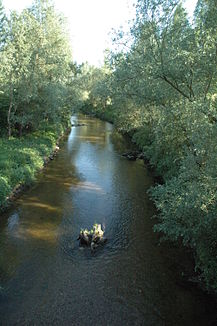
The Rodl shortly before its confluence with the Danube in Ottensheim (view in the direction of flow) |
||
| Data | ||
| location | Mühlviertel , Upper Austria | |
| River system | Danube | |
| Drain over | Danube → Black Sea | |
| source | at Sternstein 48 ° 33 ′ 32 ″ N , 14 ° 16 ′ 28 ″ E |
|
| Source height | approx. 980 m above sea level A. | |
| muzzle | near Ottensheim in the Danube Coordinates: 48 ° 19 '42 " N , 14 ° 10' 16" E 48 ° 19 '42 " N , 14 ° 10' 16" E |
|
| Mouth height | approx. 255 m above sea level A. | |
| Height difference | approx. 725 m | |
| Bottom slope | approx. 17 ‰ | |
| length | 42.4 km | |
| Catchment area | 268 km² | |
| Discharge at the Rottenegg A Eo gauge : 227.4 km² Location: 6.28 km above the mouth |
NNQ (09/30/2003) MNQ 1961–2010 MQ 1961–2010 Mq 1961–2010 MHQ 1961–2010 HHQ (08/12/2002) |
8 l / s 770 l / s 3.33 m³ / s 14.6 l / (s km²) 45.4 m³ / s 170 m³ / s |
| Right tributaries | Steinbach, Distelbach, Ranitz, Kleine Rodl, Eschelbach | |
| Small towns | Bad Leonfelden | |
| Small toboggan | ||
| River system | Danube | |
| source | on Schallenberg north of St. Veit in the Mühlkreis 48 ° 30 ′ 16 ″ N , 14 ° 10 ′ 15 ″ E |
|
| Source height | approx. 760 m above sea level A. | |
| muzzle | at Rottenegg in the Große Rodl 48 ° 22 ′ 5 ″ N , 14 ° 8 ′ 15 ″ E |
|
| Mouth height | approx. 270 m above sea level A. | |
| Height difference | approx. 490 m | |
| Bottom slope | approx. 24 ‰ | |
| length | 20.4 km | |
The Rodl is a northern tributary of the Danube in Upper Austria . Its main arm, the Große Rodl , rises north of Bad Leonfelden am Sternstein . In a south-westerly direction it flows through Zwettl to the Rodl and north-west past Gramastetten and Lichtenhag castle ruins . Below the Rottenegg castle ruins in the district of the same name in Sankt Gotthard im Mühlkreis , it joins the Kleiner Rodl to Rodl, which rises in St. Veit im Mühlkreis . In the west of Ottensheim near Höflein it flows into the Danube.
In the Rodl native fish are the brown trout , in the lower reaches also barbel .
Both the Große Rodl and the Kleine Rodl are used by several small power plants to generate electricity from renewable energy.
The earliest written evidence of the river's name is from 777 and is "Raotula". One starts from an initial form * Raudila / -ula . The name could go back to Celtic roudos (red) and was changed by Slavic and Germanic settlers. The name refers to the reddish color of the granite rock in the river bed.
Web links
- Pesenbach – Gusen , Upper Austria. State Fisheries Association
Individual evidence
- ↑ a b c d Digital Upper Austrian Room Information System (DORIS)
- ^ A b c Flussdialog Upper Austria: Characteristics of the Rodl
- ↑ Federal Ministry of Agriculture, Forestry, Environment and Water Management (ed.): Hydrographisches Jahrbuch von Österreich 2010. 118th volume. Vienna 2012, p. OG 165, PDF (12.6 MB) on bmlrt.gv.at (2010 yearbook)
- ^ Ernst Schwarz: The place names of eastern Upper Austria (= Pr. German studies ). Kraus Verlag, Reichenberg, p. 99 .
- ↑ Peter Wiesinger: The settlement of the lower and middle Mühlviertel in Upper Austria from a naming perspective . Ed .: Albrecht Greule, Hans-Walter Herrmann, Klaus Ridder, Andreas Schorr (= studies on literature, language and history in Europe ). Röhrig Universitätsverlag, St. Ingbert 2008, ISBN 978-3-86110-436-0 , p. 578 .
